
RiscBal - App

Government
info
1K+
Downloads

Everyone
info


About this app
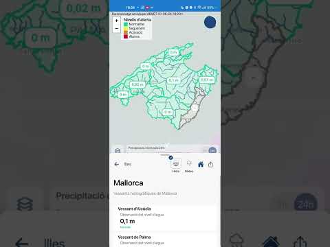
RiscBal-App is an application developed by the Natural Risks and Emergencies Observatory of the Balearic Islands - RiscBal with real-time information on floods, forest fires, mass movements, droughts and destructive storms in the Balearic Islands.
This RiscBal-App version is under testing phase; it mainly uses the RiscBal-Control environmental monitoring network. It currently provides information on rainfall, soil wetness, and air temperature every 10 minutes at stations RiscBal-Control stations and rainfall and air temperature every hour from 42 AEMET stations. It also provides information every 5 minutes on water level at 55 RiscBal-Control hydrometric stations located in rivers with a significant flood risk, as well as a 2-hour forecast at these same stations and dangerous places on the road network. Therefore, during risky events, yellow, orange or red alert warnings are issued.
This RiscBal-App version is under testing phase; it mainly uses the RiscBal-Control environmental monitoring network. It currently provides information on rainfall, soil wetness, and air temperature every 10 minutes at stations RiscBal-Control stations and rainfall and air temperature every hour from 42 AEMET stations. It also provides information every 5 minutes on water level at 55 RiscBal-Control hydrometric stations located in rivers with a significant flood risk, as well as a 2-hour forecast at these same stations and dangerous places on the road network. Therefore, during risky events, yellow, orange or red alert warnings are issued.
Updated on
Safety starts with understanding how developers collect and share your data. Data privacy and security practices may vary based on your use, region, and age. The developer provided this information and may update it over time.

No data shared with third parties
Learn more about how developers declare sharing

No data collected
Learn more about how developers declare collection

Data isn’t encrypted
Data can’t be deleted
What’s new
- Added floods layers into layer selector: water depth, water velocity, flood area, referential flow zone, first floors and basements
- At meteorological stations, in the temperature graph, added “thermal sensation” variable
- Added bounding box limit to map
- iOS error with flood layers fix
- Language selector implemented in the profile section
- Translations errors fixed
- At meteorological stations, in the temperature graph, added “thermal sensation” variable
- Added bounding box limit to map
- iOS error with flood layers fix
- Language selector implemented in the profile section
- Translations errors fixed
App support
phone
Phone number
+34971172810
About the developer
FUNDACIO UNIVERSITAT-EMPRESA DE LES ILLES BALEARS MP
developers@fueib.org
CARRETERA VALLDEMOSSA
07120 PALMA
Spain
+34 971 17 32 94