

Ceasefire Ligth

1K+
Downloads

Everyone
info


About this app
Developed by the Dom Luiz Institute (IDL) of the Faculty of Sciences of the University of Lisbon (FCUL), CeaseFire Light aims to provide, in a simple and direct way, maps with information related to the meteorological danger of rural fire in Mainland Portugal.
CeaseFire Light uses the information provided by the Satellite Application Facility on Land Surface Analysis (Land SAF) project, a project by EUMETSAT (the European agency for the exploration of meteorological satellites), coordinated by the Portuguese Institute of the Sea and the Atmosphere (IPMA).
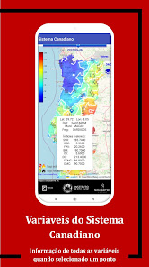
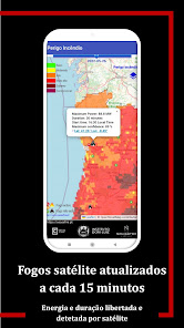
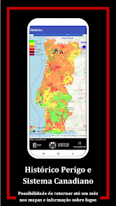
The maps provided contain information for the day, for the previous five days and for the following five days of all Canadian Fire System Index indices and fire hazard classes that result from a calibration of the indices using the history of observations of energy released by large fires, based on records made every 15 minutes by the SEVIRI instrument on board EUMETSAT geostationary satellites. These maps also include real-time information on the location, duration and energy released by the fires detected by EUMETSAT satellites and also all the information provided by the National Emergency and Civil Protection Agency (ANEPC) about the state and means of combat involved in all cases. fires which, at the time of consultation, have already been recorded.
Daily maps are also available with information regarding the ease of ignition and the difficulty of the aftermath, which result from the application of algorithms developed by the Center for Research and Agro-environmental and Biological Technologies (CITAB) of the University of Trás-os-Montes and Alto Douro (UTAD).
CeaseFire Light uses the information provided by the Satellite Application Facility on Land Surface Analysis (Land SAF) project, a project by EUMETSAT (the European agency for the exploration of meteorological satellites), coordinated by the Portuguese Institute of the Sea and the Atmosphere (IPMA).
The maps provided contain information for the day, for the previous five days and for the following five days of all Canadian Fire System Index indices and fire hazard classes that result from a calibration of the indices using the history of observations of energy released by large fires, based on records made every 15 minutes by the SEVIRI instrument on board EUMETSAT geostationary satellites. These maps also include real-time information on the location, duration and energy released by the fires detected by EUMETSAT satellites and also all the information provided by the National Emergency and Civil Protection Agency (ANEPC) about the state and means of combat involved in all cases. fires which, at the time of consultation, have already been recorded.
Daily maps are also available with information regarding the ease of ignition and the difficulty of the aftermath, which result from the application of algorithms developed by the Center for Research and Agro-environmental and Biological Technologies (CITAB) of the University of Trás-os-Montes and Alto Douro (UTAD).
Updated on
Safety starts with understanding how developers collect and share your data. Data privacy and security practices may vary based on your use, region, and age. The developer provided this information and may update it over time.

No data shared with third parties
Learn more about how developers declare sharing

No data collected
Learn more about how developers declare collection
What's new
Otimizações diversas.
Processos de seleção de mapas.
Formatação legível da informação de índices.
Processos de seleção de mapas.
Formatação legível da informação de índices.