
BioDivCollector
50+
Downloads

Everyone
info


About this app
You map biodiversity data and use the applications from www.infospecies.ch for your species surveys. Do you want to collect additional parameters and geometries efficiently or do you collect geographic biodiversity data without species information?
BioDivCollector allows you to set up your collection projects with your own parameters and to carry out the surveys efficiently alone or with user groups and to easily monitor all of your survey campaigns.
The online WebGIS tool (https://biodivcollector.ch) enables you to complete the configuration:
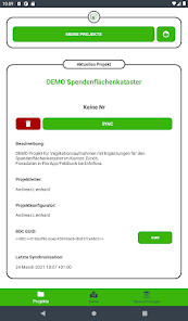
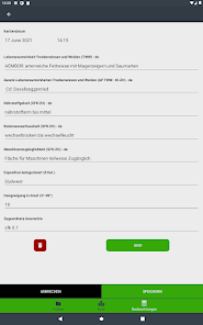
Determine the user groups and assign those who collect them
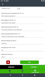
Use existing or redefine forms and data fields for data collection with the app
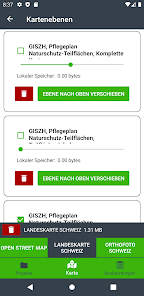
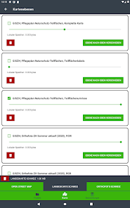
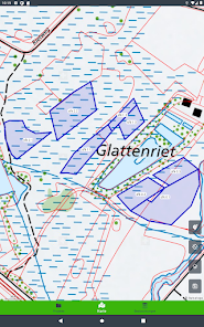
Define your own map backgrounds by integrating WMS
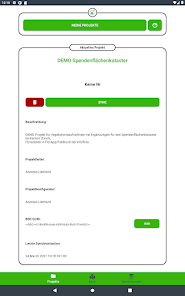
Keep track of multiple capture projects and campaigns
Protect data records of completed projects from further editing
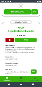
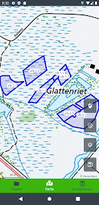
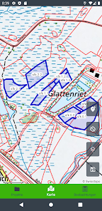
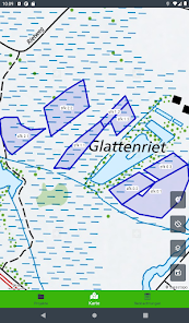
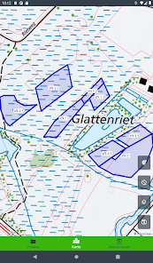
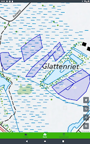
As soon as the project is configured, it is available in the mobile app for all assigned users for synchronization and offline use in the field. In the field, users can capture their geographically referenced data using GPS, orthophotos, maps, and any other geographical reference material that you have included in your project.
In the field, BioDivCollector can be used together with other apps from the Infospecies family as well as other third-party applications to supplement possible surveys. Copy any BioDiv data record ID into the third-party applications you use to merge this data with the BioDiv information. The data can be merged in real time (via geospatial services) or as required (via a download service).
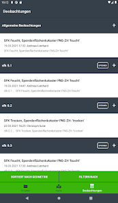
As soon as a data connection is established, recorded data can be synchronized at any time and shared with all project participants. The entire data set can be viewed in WebGIS and conveniently processed further. With the WFS data service, the recordings and processing can be displayed and evaluated live in GIS systems. All data records can also be easily exported, further processed as a table or with a desktop GIS and then imported back into the BioDivCollector for data services or for new field work.
© Fachstelle Naturschutz, Building Department Canton Zurich, 2021
BioDivCollector allows you to set up your collection projects with your own parameters and to carry out the surveys efficiently alone or with user groups and to easily monitor all of your survey campaigns.
The online WebGIS tool (https://biodivcollector.ch) enables you to complete the configuration:
Determine the user groups and assign those who collect them
Use existing or redefine forms and data fields for data collection with the app
Define your own map backgrounds by integrating WMS
Keep track of multiple capture projects and campaigns
Protect data records of completed projects from further editing
As soon as the project is configured, it is available in the mobile app for all assigned users for synchronization and offline use in the field. In the field, users can capture their geographically referenced data using GPS, orthophotos, maps, and any other geographical reference material that you have included in your project.
In the field, BioDivCollector can be used together with other apps from the Infospecies family as well as other third-party applications to supplement possible surveys. Copy any BioDiv data record ID into the third-party applications you use to merge this data with the BioDiv information. The data can be merged in real time (via geospatial services) or as required (via a download service).
As soon as a data connection is established, recorded data can be synchronized at any time and shared with all project participants. The entire data set can be viewed in WebGIS and conveniently processed further. With the WFS data service, the recordings and processing can be displayed and evaluated live in GIS systems. All data records can also be easily exported, further processed as a table or with a desktop GIS and then imported back into the BioDivCollector for data services or for new field work.
© Fachstelle Naturschutz, Building Department Canton Zurich, 2021
Updated on
Safety starts with understanding how developers collect and share your data. Data privacy and security practices may vary based on your use, region, and age. The developer provided this information and may update it over time.

No data shared with third parties
Learn more about how developers declare sharing

This app may collect these data types
Personal info and Photos and videos

Data is encrypted in transit

You can request that data be deleted