
SwitzerlandMobility
4.3star
2.39K reviews
500K+
Downloads

Everyone
info



About this app
The SwitzerlandMobility app is the perfect companion for anyone who likes to be outdoors, whether in summer or winter.
Discover new routes, be inspired, and plan and navigate your experiences.
Discover the most attractive routes in Switzerland
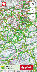
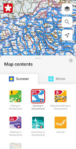
The SwitzerlandMobility app offers access to the 1,500 most enticing routes in Switzerland and the Principality of Liechtenstein. In summer, the range includes hiking, cycling, mountain biking, skating and canoeing. In winter, you will find a wide selection of winter hiking trails, snowshoe routes, cross-country ski trails and toboggan runs. The route network is available to you in the highest map quality with national maps from swisstopo, up to a scale of 1:10,000.
Simple planning of tours
You will find thorough descriptions and detailed photo reports for each route. This gives you a good idea of what to expect at the site. The public transport stops, including the next departure times with a direct link to the SBB app as well as a wealth of additional information on accommodation options, sights, stopover locations, bike rental and bike service stations make it easy to prepare your trip.
Travelling safely
The SwitzerlandMobility routes are official and are signposted locally. Current route closures and diversions are also available in the app. The information is updated daily, so you have the latest details at all times.
Location tracking and compass feature
You can always find the right trail with the SwitzerlandMobility app. You can easily see where you are on the map with location tracking. The compass feature aligns the map in the direction you are looking so that you can follow your planned tour.
Plan your own tours
Plan your own tours on the swisstopo map. The distance, ascents and descents, altitude profile and time required are calculated automatically. This feature is available to you with SwitzerlandMobility Plus (charges apply).
Use the app without network reception
Planned tours, map sections and all route information are available offline in the app. This is ideal for alpine terrain where there is no network reception. Save any map section with the content you choose. This feature is available to you with SwitzerlandMobility Plus (charges apply).
Record your own tours in the app
With SwitzerlandMobility Plus you can have your tour automatically recorded in the app. This gives you an overview of all important information such as distance, altitude covered and time required. This feature is also available to you with SwitzerlandMobility Plus (charges apply).
Find out more about the advantages and additional features of SwitzerlandMobility Plus: www.switzerlandmobilty.ch/de/switzerlandmobility-plus
Discover new routes, be inspired, and plan and navigate your experiences.
Discover the most attractive routes in Switzerland
The SwitzerlandMobility app offers access to the 1,500 most enticing routes in Switzerland and the Principality of Liechtenstein. In summer, the range includes hiking, cycling, mountain biking, skating and canoeing. In winter, you will find a wide selection of winter hiking trails, snowshoe routes, cross-country ski trails and toboggan runs. The route network is available to you in the highest map quality with national maps from swisstopo, up to a scale of 1:10,000.
Simple planning of tours
You will find thorough descriptions and detailed photo reports for each route. This gives you a good idea of what to expect at the site. The public transport stops, including the next departure times with a direct link to the SBB app as well as a wealth of additional information on accommodation options, sights, stopover locations, bike rental and bike service stations make it easy to prepare your trip.
Travelling safely
The SwitzerlandMobility routes are official and are signposted locally. Current route closures and diversions are also available in the app. The information is updated daily, so you have the latest details at all times.
Location tracking and compass feature
You can always find the right trail with the SwitzerlandMobility app. You can easily see where you are on the map with location tracking. The compass feature aligns the map in the direction you are looking so that you can follow your planned tour.
Plan your own tours
Plan your own tours on the swisstopo map. The distance, ascents and descents, altitude profile and time required are calculated automatically. This feature is available to you with SwitzerlandMobility Plus (charges apply).
Use the app without network reception
Planned tours, map sections and all route information are available offline in the app. This is ideal for alpine terrain where there is no network reception. Save any map section with the content you choose. This feature is available to you with SwitzerlandMobility Plus (charges apply).
Record your own tours in the app
With SwitzerlandMobility Plus you can have your tour automatically recorded in the app. This gives you an overview of all important information such as distance, altitude covered and time required. This feature is also available to you with SwitzerlandMobility Plus (charges apply).
Find out more about the advantages and additional features of SwitzerlandMobility Plus: www.switzerlandmobilty.ch/de/switzerlandmobility-plus
Updated on
Safety starts with understanding how developers collect and share your data. Data privacy and security practices may vary based on your use, region, and age. The developer provided this information and may update it over time.

No data shared with third parties
Learn more about how developers declare sharing

This app may collect these data types
Location, Personal info and 3 others

Data is encrypted in transit

You can request that data be deleted
Ratings and reviews
4.3
2.18K reviews

Justin Ball
- Flag inappropriate
October 18, 2025
I liked the old interface web interface much more than the new one. I don't think it makes sense to have the tour information in a horizontal panel along the bottom. When I expand the tour panel on my 16:9 monitor, it leaves me with just a very narrow horizontal view on the map. This makes drawing tours difficult (especially north-south routes). I liked the old interface, where the information on the tour was in a vertical panel on the left side, which left a larger, more square view of the map

Patricia Moll
- Flag inappropriate
- Show review history
February 1, 2025
I love the app, especially now that I can draw paths! I have one issue, though: it would be great if I could change the language from the system default. Edit: I realized that saved routes do not contain any of my manually created waypoints. So if I ever want to go back and edit a route, it does not stick to my previous waypoints but instead tries to calculate the shortest path from the start to the current editing location. This makes it impossible to make little changes.
2 people found this review helpful
Stiftung SchweizMobil
February 19, 2025
Danke für Ihr Feedback. Bitte wenden Sie sich an info@schweizmobil.ch, damit wir das Problem besser analysieren können. Freundliche Grüsse Stiftung SchweizMobil

A Google user
- Flag inappropriate
December 12, 2019
Very good app if in combination with the browser version and the annual paid subscription (totally worth it). Please improve the map saving feature: it would be good to be able to select a much larger map to save instead of the small square provided. It would be even better to be able to save the maps with the original raster of the 1:25000 charts (so that the coverage area is identical to the paper version). Also it would be great if you can add the 1:50'000 winter sports map.
18 people found this review helpful
What’s new
Snow depth map by Exolabs
The snow depth map by Exolabs now shows you the current snow levels to help plan your next winter activity with SwitzerlandMobility.
The snow depth map by Exolabs now shows you the current snow levels to help plan your next winter activity with SwitzerlandMobility.
App support
About the developer
SchweizMobil
info@schweizmobil.ch
Monbijoustrasse 61
3007 Bern
Switzerland
+41 31 313 02 70