
Aeródromos de Chile
In-app purchases

Everyone
info
500+
Downloads

About this app
IMPORTANT DISCLAIMER
This application is NOT affiliated with, endorsed by, or related to the Chilean Civil Aviation Authority (DGAC) or any government entity in Chile or any other country.
The aeronautical information displayed in this application is obtained from public sources, primarily the Chilean AIP (Aeronautical Information Publication), published by the DGAC and available at:
https://www.dgac.gob.cl and https://aipchile.dgac.gob.cl
This application is provided for informational and reference purposes only.
It should NOT be used for flight planning or operational decision-making.
Before any flight, you should always consult the official AIP publications and current NOTAMs.
IMPORTANT DISCLAIMER
This application is NOT affiliated with, endorsed by, or connected to the Chilean Civil Aviation Authority (DGAC) or any government entity in Chile or elsewhere.
The aeronautical information displayed in this app is compiled from publicly available sources, primarily the Chilean AIP (Aeronautical Information Publication), published by the DGAC and available at:
https://www.dgac.gob.cl and https://aipchile.dgac.gob.cl
This app is provided for reference and informational purposes ONLY.
It MUST NOT be used for flight planning or operational decision-making.
Official AIP publications and NOTAMs must always be consulted before any flight.
This application has no affiliation with the Chilean DGAC or any other government entity in Chile or any other country.
The information in this application was obtained from AIP Volumes I and II, which are publicly available on the Chilean DGAC website: https://aipchile.dgac.gob.cl
This application is designed for all pilots, both commercial and private. This application should be used for reference purposes only. To plan your flight, you must use AIP Vol I and II.
This application is ideal for carrying in your flight bag, as it allows you to find all the aerodromes in Chile with their main characteristics:
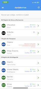
Database of Airports and Aerodromes throughout Chile.
Aerodromes sorted by region and alphabetically.
Aerodrome search system by name or designator.
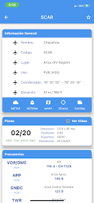
Data for each runway (dimensions and surface).
Frequencies for each aerodrome or airport.
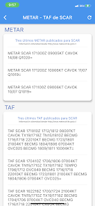
View METAR and NOTAM for each aerodrome that has them available, with the option to view them decoded (internet connection required).
IFR and VFR charts.
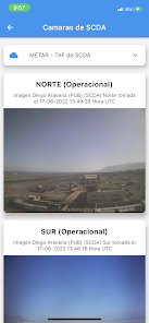
Aerodrome cameras.
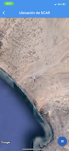
View each runway via Google Maps (internet connection required).
Magnetic compass indicating the direction and distance from your position to the selected aerodrome.
Screen with a list of the aerodromes closest to your position, ordered by distance. WARNING:
THIS APPLICATION SHOULD NOT BE USED FOR AIR OPERATIONS. Do not use this application to plan your flight; the data in this application may be outdated or contain errors.
This application is NOT affiliated with, endorsed by, or related to the Chilean Civil Aviation Authority (DGAC) or any government entity in Chile or any other country.
The aeronautical information displayed in this application is obtained from public sources, primarily the Chilean AIP (Aeronautical Information Publication), published by the DGAC and available at:
https://www.dgac.gob.cl and https://aipchile.dgac.gob.cl
This application is provided for informational and reference purposes only.
It should NOT be used for flight planning or operational decision-making.
Before any flight, you should always consult the official AIP publications and current NOTAMs.
IMPORTANT DISCLAIMER
This application is NOT affiliated with, endorsed by, or connected to the Chilean Civil Aviation Authority (DGAC) or any government entity in Chile or elsewhere.
The aeronautical information displayed in this app is compiled from publicly available sources, primarily the Chilean AIP (Aeronautical Information Publication), published by the DGAC and available at:
https://www.dgac.gob.cl and https://aipchile.dgac.gob.cl
This app is provided for reference and informational purposes ONLY.
It MUST NOT be used for flight planning or operational decision-making.
Official AIP publications and NOTAMs must always be consulted before any flight.
This application has no affiliation with the Chilean DGAC or any other government entity in Chile or any other country.
The information in this application was obtained from AIP Volumes I and II, which are publicly available on the Chilean DGAC website: https://aipchile.dgac.gob.cl
This application is designed for all pilots, both commercial and private. This application should be used for reference purposes only. To plan your flight, you must use AIP Vol I and II.
This application is ideal for carrying in your flight bag, as it allows you to find all the aerodromes in Chile with their main characteristics:
Database of Airports and Aerodromes throughout Chile.
Aerodromes sorted by region and alphabetically.
Aerodrome search system by name or designator.
Data for each runway (dimensions and surface).
Frequencies for each aerodrome or airport.
View METAR and NOTAM for each aerodrome that has them available, with the option to view them decoded (internet connection required).
IFR and VFR charts.
Aerodrome cameras.
View each runway via Google Maps (internet connection required).
Magnetic compass indicating the direction and distance from your position to the selected aerodrome.
Screen with a list of the aerodromes closest to your position, ordered by distance. WARNING:
THIS APPLICATION SHOULD NOT BE USED FOR AIR OPERATIONS. Do not use this application to plan your flight; the data in this application may be outdated or contain errors.
Updated on
Safety starts with understanding how developers collect and share your data. Data privacy and security practices may vary based on your use, region, and age. The developer provided this information and may update it over time.

No data shared with third parties
Learn more about how developers declare sharing

No data collected
Learn more about how developers declare collection
What’s new
Se arreglan bugs internos, se implementan nombres de cartillas
App support
About the developer
Alvaro Sebastian Valenzuela Menares
developer@aerodromoschile.com
345 Royal Liverpool Ln
Orlando, FL 32828-8020
United States