
E-walk - Hiking offline GPS
Contains adsIn-app purchases

3.4star
758 reviews
100K+
Downloads

Everyone
info


About this app
E-WALK
E-walk allows you to find your next outdoor activity, plan it, and record it. E-walk is the perfect companion for outdoors activities (such as hiking, trekking, biking, fishing, hunting, etc...) and for traveling abroad, because you can fully use it offline.
Lost in a forest? E-walk brings you back to your car. Forgot about where was this lovely boutique you noticed last year in Venice? E-walk refreshes your memory!
E-WALK KEY FEATURES
• worldwide high resolution topographic map (E-walk Topo Map), designed for hiking and outdoors activities
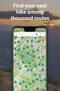
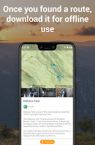
• find your next adventure among thousand routes, download them for offline use and share yours (requires a free E-walk account)
• full integration of IGNrando' (https://ignrando.fr): browse IGNrando' routes on the map, sync your IGNrando' content, upload routes to IGNrando' (requires a free IGNrando' account)
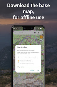
• download maps for later offline use (free for OpenStreetMap and Wikimedia Maps, with subscription for E-walk Topo Map)
• show your current location on the map
• search places (last searches are saved for offline use)
• record your hikes
• select different base maps (streets, satellite, terrain, etc...)
• plan your hikes by creating and editing KML files on the map. A KML file can contains markers, lines & polygons
E-WALK ADVANCED FEATURES
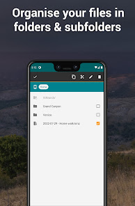
• organize your hikes in folders & subfolders
• display overlay maps (weather, roads, metro/bus, ski slopes, sea map, etc...)
• share your position via e-mail or SMS
• open a position in your other geo apps (such as Google Maps, Waze, TomTom, Sygic, Locus, Orux, MyTrails, etc...)
• share a hike by e-mail, bluetooth, etc... Either in KML file format (by default) or in GPX file format
• import GPX files (they will be converted in KMZ format)
• add custom maps in the XYZ protocol (see http://wiki.openstreetmap.org/wiki/Slippy_map_tilenames)
• add custom maps in the WMS protocol
E-WALK PLUS
E-walk has already a lot of features for free. But you can buy E-walk Plus to add the following:
• remove the ads
• have a scale on the map
• store your data on your SD card
• save / restore your data
• support E-walk's development
E-WALK MAX
E-walk Max unlocks all features of the app (excluding IGN Maps plugin). You can try it for free during 3 days. It includes all the advantages of E-walk Plus, and the following:
• download E-walk Topo Map for offline use
• pause your hikes recordings
IGN MAPS PLUGIN
The IGN maps plugin (https://play.google.com/store/apps/details?id=com.at.ewalk.plugin.ign) adds maps provided by the french national institute of geographical and forestry information (http://www.ign.fr).
CONTACT
A problem with E-walk? A suggestion? A feedback? Please do not hesitate to send an e-mail to contact@ewalk.app!
E-walk allows you to find your next outdoor activity, plan it, and record it. E-walk is the perfect companion for outdoors activities (such as hiking, trekking, biking, fishing, hunting, etc...) and for traveling abroad, because you can fully use it offline.
Lost in a forest? E-walk brings you back to your car. Forgot about where was this lovely boutique you noticed last year in Venice? E-walk refreshes your memory!
E-WALK KEY FEATURES
• worldwide high resolution topographic map (E-walk Topo Map), designed for hiking and outdoors activities
• find your next adventure among thousand routes, download them for offline use and share yours (requires a free E-walk account)
• full integration of IGNrando' (https://ignrando.fr): browse IGNrando' routes on the map, sync your IGNrando' content, upload routes to IGNrando' (requires a free IGNrando' account)
• download maps for later offline use (free for OpenStreetMap and Wikimedia Maps, with subscription for E-walk Topo Map)
• show your current location on the map
• search places (last searches are saved for offline use)
• record your hikes
• select different base maps (streets, satellite, terrain, etc...)
• plan your hikes by creating and editing KML files on the map. A KML file can contains markers, lines & polygons
E-WALK ADVANCED FEATURES
• organize your hikes in folders & subfolders
• display overlay maps (weather, roads, metro/bus, ski slopes, sea map, etc...)
• share your position via e-mail or SMS
• open a position in your other geo apps (such as Google Maps, Waze, TomTom, Sygic, Locus, Orux, MyTrails, etc...)
• share a hike by e-mail, bluetooth, etc... Either in KML file format (by default) or in GPX file format
• import GPX files (they will be converted in KMZ format)
• add custom maps in the XYZ protocol (see http://wiki.openstreetmap.org/wiki/Slippy_map_tilenames)
• add custom maps in the WMS protocol
E-WALK PLUS
E-walk has already a lot of features for free. But you can buy E-walk Plus to add the following:
• remove the ads
• have a scale on the map
• store your data on your SD card
• save / restore your data
• support E-walk's development
E-WALK MAX
E-walk Max unlocks all features of the app (excluding IGN Maps plugin). You can try it for free during 3 days. It includes all the advantages of E-walk Plus, and the following:
• download E-walk Topo Map for offline use
• pause your hikes recordings
IGN MAPS PLUGIN
The IGN maps plugin (https://play.google.com/store/apps/details?id=com.at.ewalk.plugin.ign) adds maps provided by the french national institute of geographical and forestry information (http://www.ign.fr).
CONTACT
A problem with E-walk? A suggestion? A feedback? Please do not hesitate to send an e-mail to contact@ewalk.app!
Updated on
Safety starts with understanding how developers collect and share your data. Data privacy and security practices may vary based on your use, region, and age. The developer provided this information and may update it over time.

No data shared with third parties
Learn more about how developers declare sharing

This app may collect these data types
Personal info

Data is encrypted in transit

You can request that data be deleted
Ratings and reviews
3.4
713 reviews

Bob Danek
- Flag inappropriate
- Show review history
January 3, 2021
Fantastic app! Has EVERY trail, both marked and unmarked, in my area. Works flawlessly. I am a Firefighter and EMT in a rural area and will be recommending this app as our goto app for department search and rescue operations since it has so much detail. My only complaint is that the topo map elevations are metric and no way to change to imperial units
33 people found this review helpful
Tim Autin
January 30, 2021
Thank you very much for your review 🙂! I'll see for the next map update if displaying the elevations in both systems doesn't clutter the map too much. I'm also planning to add the elevation (in the correct system) when long pressing the map, but likely not before next year. EDIT: I added the elevation in feet today 😉

Anne Boyle
- Flag inappropriate
October 15, 2024
Great app. I use it to track casual treks and find it great for keeping me on the right track and getting me back home safe! Excellent support too. My query was answered within minutes and the issue fixed shortly after!
Tim Autin
October 15, 2024
Thank you very much Anne :)

Mattt Wilson
- Flag inappropriate
August 1, 2024
Useless in rural area & totally unintuitive. The only maps available where there's no signal just show streets, not footpaths. A total absence of instructions means that there's no way to set up your own route before you leave home. It seldom recognises the location that you type in & won't put markers on the map where you want them. A waste of memory space on my phone & being deleted very shortly.
Tim Autin
August 21, 2024
Sorry you didn't like it, but E-walk Topo Map is based on OpenStreetMap data, the best worldwide open source map available, used by most if not all hiking apps. Could you tell where did you find it useless? Could you also give me more details (contact@ewalk.app) regarding your problem with markers, as you are the only one reporting this? Thanks
What's new
This update brings all IGN maps back (including SCAN maps) & fixes a bug preventing tracking to start on some devices.
App support
About the developer
AUTIN TIMOTHEE PAUL OVIDE
contact@ewalk.app
VC N 145 1226 CHEMIN DU VAL D AREN
83330 LE BEAUSSET
France
+33 9 82 33 14 59