
Global Mapper Mobile
3,7star
386 ta sharh
100 ming+
Yuklanmalar

Hamma uchun
info

Bu ilova haqida
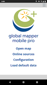
Global Mapper Mobile
Bring your GIS workflow to the field.
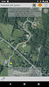
Global Mapper Mobile® is a powerful Android application for viewing and collecting GIS data. It utilizes the GPS capabilities of mobile devices to provide situational awareness and locational intelligence for remote mapping projects. A perfect complement to the desktop version of Global Mapper, the mobile app provides maps-in-hand functionality for engineers, surveyors, wildlife managers, foresters, and anyone whose job requires access to spatial data in remote locations.
Global Mapper Mobile can display vector, raster, and elevation data layers that have been transferred from the desktop version of the software. It also provides tools for drawing, tracking, and form-based data collection using pre-configured attributes and picklists.
Global Mapper Mobile Base Version (Free)
The base version of Global Mapper Mobile is free of charge and provides an array of features and functions, including:
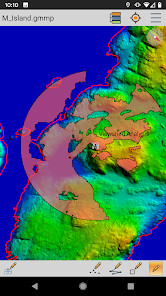
• Vector, raster, and terrain data display
• GPS location display
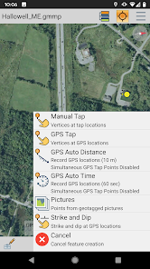
• Point, line, and polygon feature creation using GPS location
• Editing of existing vector features
• Capture of images in the field
• Creation of Picture Points from geotagged images
• Attribute and feature notation recording for new or existing vector features
• Online access to Open Street Map data
Global Mapper Mobile Pro
The Pro version of Global Mapper Mobile, available as an in-app purchase, supplements the functionality of the base version with an array of professional-grade tools, including:
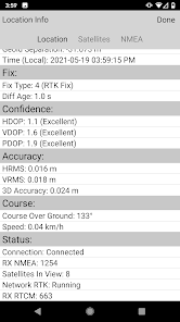
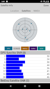
• Advanced GPS support for connection to high-accuracy GNSS devices from vendors such as Bad Elf, EOS, Juniper, and others
• RTK correction via built-in NTRIP client
• GPS Averaging
• Terrain shader and water level display options
• Custom online source options and online data saving for offline use
• Simultaneous feature creation
• Viewshed creation
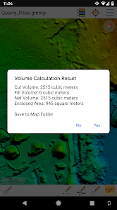
• Volume calculation
• Data reprojection
• Address searching
• Geopackage and GeoPDF format support
Global Mapper Mobile Pro is available for purchase from the Blue Marble Geographics website. The license is based on an annual subscription from the date of purchase that can be renewed each year. Enterprise licensing options are also available. For more information, email orders@bluemarblegeo.com.
Note: Continued use of GPS running in the background can dramatically decrease battery life.
Privacy Policy:
https://www.bluemarblegeo.com/privacy-policy/
Terms of Use:
https://www.bluemarblegeo.com/licensing-policy/
Bring your GIS workflow to the field.
Global Mapper Mobile® is a powerful Android application for viewing and collecting GIS data. It utilizes the GPS capabilities of mobile devices to provide situational awareness and locational intelligence for remote mapping projects. A perfect complement to the desktop version of Global Mapper, the mobile app provides maps-in-hand functionality for engineers, surveyors, wildlife managers, foresters, and anyone whose job requires access to spatial data in remote locations.
Global Mapper Mobile can display vector, raster, and elevation data layers that have been transferred from the desktop version of the software. It also provides tools for drawing, tracking, and form-based data collection using pre-configured attributes and picklists.
Global Mapper Mobile Base Version (Free)
The base version of Global Mapper Mobile is free of charge and provides an array of features and functions, including:
• Vector, raster, and terrain data display
• GPS location display
• Point, line, and polygon feature creation using GPS location
• Editing of existing vector features
• Capture of images in the field
• Creation of Picture Points from geotagged images
• Attribute and feature notation recording for new or existing vector features
• Online access to Open Street Map data
Global Mapper Mobile Pro
The Pro version of Global Mapper Mobile, available as an in-app purchase, supplements the functionality of the base version with an array of professional-grade tools, including:
• Advanced GPS support for connection to high-accuracy GNSS devices from vendors such as Bad Elf, EOS, Juniper, and others
• RTK correction via built-in NTRIP client
• GPS Averaging
• Terrain shader and water level display options
• Custom online source options and online data saving for offline use
• Simultaneous feature creation
• Viewshed creation
• Volume calculation
• Data reprojection
• Address searching
• Geopackage and GeoPDF format support
Global Mapper Mobile Pro is available for purchase from the Blue Marble Geographics website. The license is based on an annual subscription from the date of purchase that can be renewed each year. Enterprise licensing options are also available. For more information, email orders@bluemarblegeo.com.
Note: Continued use of GPS running in the background can dramatically decrease battery life.
Privacy Policy:
https://www.bluemarblegeo.com/privacy-policy/
Terms of Use:
https://www.bluemarblegeo.com/licensing-policy/
Oxirgi yangilanish
Xavfsizlik — dastur ishlab chiquvchilar maʼlumotlaringizni qanday jamlashi va ulashishini tushinishdan boshlanadi. Maʼlumotlar maxfiyligi va xavfsizlik amaliyotlari ilovadan foydalanish, hudud va yoshga qarab farq qilishi mumkin. Bu axborot dastur ishlab chiquvchi tomonidan taqdim etilgan va keyinchalik yangilanishi mumkin.

Tashqi hamkorlarga hech qanday axborot ulashilmagan
Dastur ishlab chiquvchilar axborot ulashilishini qanday aytishi haqida batafsil

Ushbu ilova quyidagi axborot turlarini toʻplashi mumkin
Ilova tarixi, Ilova axboroti va unumdorlik va Qurilma yoki boshqa identifikatorlar

Maʼlumotlar uzatish vaqtida shifrlanadi

Maʼlumotlarni oʻchirishni soʻrashingiz mumkin
Reytinglar va sharhlar
3,7
368 ta sharh
Nima yangiliklar
Standard (free):
- Raster Info tool
- Digitizer trace mode
- Improved vector, raster, and terrain data render speed
- Dark Theme improvements
- Fix file import issue on Android 13
Pro Subscription:
- Support for viewshed calculation from current GPS location
- Save viewshed point and create viewshed area features
- Expanded volume calculation options to include pile volume and vertex elevation
- Added support for Trimble GNSS devices