PlanMyRoute: Run Route Planner
Contains adsIn-app purchases
3.7star
960 reviews
100K+
Downloads

Everyone
info

About this app
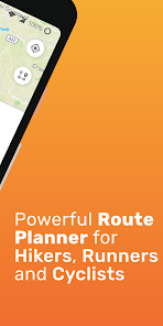
PlanMyRoute is a route planner that helps you create routes anywhere in the world. Using the app you can plan a route before you go running, road cycling, mountain biking or explore trails on hike.
Plan your Customized Route
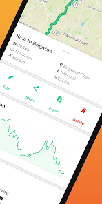
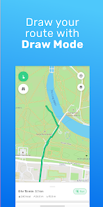
Wherever you want to explore an area, plan hikes, or simply walk around, it’s very easy to plan routes in the map and visually follow the path. From the main route planner screen, you can simply type in the location you want to go or even more conveniently use your fingers to draw a route across the map. Once the route is drawn in the map, it will show you useful information such as the distance in Km or Miles. Finally, save the map routes in your profile and you will be able to do the same route any day, ideal for running routines.
A-B Mode
Loved by many of the users, the route planner has an A-B mode, which allows which lets you pick a start and end location (along with any waypoints across the path), and then select one of the suggested routes that are calculated automatically. This way you can always choose the route you prefer, and find the best way to cross the map.
Maps
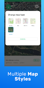
Another great feature that was requested by users was the ability to choose between different types of maps. PlanMyRoute route planner comes with multiple maps to suite different activities, such as “normal” which shows the classic map style, “satellite” which shows the map from a satellite view, “cycling” which makes the map easier for cycling and “hiking” that as the name suggests, it is meant for hiking routes.
Choose your route based on the extra information
To help you have a better understanding of your upcoming adventure, the route planner provides extra information about your route.
Currently this includes:
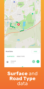
• Road Surface: it shows if the road is paved or unpaved to better understand if its suitable for walking.
• Road Type: it shows what type of road is, such as street, path or major road if for example you want to avoid car traffic or want to ride the bike.
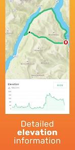
• Elevation profile across your route: This helpful info will help you know whether you need to prepare for hills or not.
• Elevation gain & elevation loss: How much elevation will this route or lose?
• Activity duration: simple but essential information about how long the activity is going to take.
Snap to road
When using the route planner in draw mode to draw out your route, you might find it difficult to draw a route that sticks to the roads and trails. However, with the “Snap to road” feature it will allow you to automatically adjust your hand-drawn routes so that they are aligned along the right roads and trails on your route. This way you will be able to track any footpath or running routes, and map any cycling or hiking roads with no sweat!
Upgraded Version
Although the essential function of planning routes work with the free version, you can opt for a premium service that will unlock additional features that will improve the route planning experience:
The following features are available if you upgrade:
🌟 Cycling Advanced and Hiking Map Styles: Improve the customization of your routes!
🌟 Snap to road: Easily plan your journey through the roads!
🌟 Calories burn estimation: In order to keep healthy and fit, it is essential to know how many calories you burn!
🌟 Unlimited number of running routes: Draw, plan and save infinite number of routes!
🌟 Sync between devices - Sync your routes with your Google account so that you never lose them, and also have the ability to view them on other devices.
Hope you enjoy the app and happy planning!
Plan your Customized Route
Wherever you want to explore an area, plan hikes, or simply walk around, it’s very easy to plan routes in the map and visually follow the path. From the main route planner screen, you can simply type in the location you want to go or even more conveniently use your fingers to draw a route across the map. Once the route is drawn in the map, it will show you useful information such as the distance in Km or Miles. Finally, save the map routes in your profile and you will be able to do the same route any day, ideal for running routines.
A-B Mode
Loved by many of the users, the route planner has an A-B mode, which allows which lets you pick a start and end location (along with any waypoints across the path), and then select one of the suggested routes that are calculated automatically. This way you can always choose the route you prefer, and find the best way to cross the map.
Maps
Another great feature that was requested by users was the ability to choose between different types of maps. PlanMyRoute route planner comes with multiple maps to suite different activities, such as “normal” which shows the classic map style, “satellite” which shows the map from a satellite view, “cycling” which makes the map easier for cycling and “hiking” that as the name suggests, it is meant for hiking routes.
Choose your route based on the extra information
To help you have a better understanding of your upcoming adventure, the route planner provides extra information about your route.
Currently this includes:
• Road Surface: it shows if the road is paved or unpaved to better understand if its suitable for walking.
• Road Type: it shows what type of road is, such as street, path or major road if for example you want to avoid car traffic or want to ride the bike.
• Elevation profile across your route: This helpful info will help you know whether you need to prepare for hills or not.
• Elevation gain & elevation loss: How much elevation will this route or lose?
• Activity duration: simple but essential information about how long the activity is going to take.
Snap to road
When using the route planner in draw mode to draw out your route, you might find it difficult to draw a route that sticks to the roads and trails. However, with the “Snap to road” feature it will allow you to automatically adjust your hand-drawn routes so that they are aligned along the right roads and trails on your route. This way you will be able to track any footpath or running routes, and map any cycling or hiking roads with no sweat!
Upgraded Version
Although the essential function of planning routes work with the free version, you can opt for a premium service that will unlock additional features that will improve the route planning experience:
The following features are available if you upgrade:
🌟 Cycling Advanced and Hiking Map Styles: Improve the customization of your routes!
🌟 Snap to road: Easily plan your journey through the roads!
🌟 Calories burn estimation: In order to keep healthy and fit, it is essential to know how many calories you burn!
🌟 Unlimited number of running routes: Draw, plan and save infinite number of routes!
🌟 Sync between devices - Sync your routes with your Google account so that you never lose them, and also have the ability to view them on other devices.
Hope you enjoy the app and happy planning!
Updated on
Safety starts with understanding how developers collect and share your data. Data privacy and security practices may vary based on your use, region, and age. The developer provided this information and may update it over time.

No data shared with third parties
Learn more about how developers declare sharing

No data collected
Learn more about how developers declare collection
Ratings and reviews
3.7
918 reviews

A Google user
- Flag inappropriate
May 27, 2019
FindARun has probably the best looking UI of any fitness app that I have used. It also has a very good ideas, like showing estimated calorie burn. I like the minimalist design and how all of the colors blend together, and i like how subtle the line that shows your path is. There are a couple things that would make this app even better than it already is, too! The most important change would be a fully-functional snap to road feature. Another would be a visual for 1 mile, 2 miles, etc.
25 people found this review helpful
Yuber Apps
June 1, 2019
Thanks for the review, and I'm glad that you're enjoying the app! What sort of extra features would you like for snap to road? And by the 1 mile, 2 mile visual, do you have in mind some sort of a 1 mile radius on the map around the last point added to the route?
A Google user
- Flag inappropriate
- Show review history
October 29, 2019
Update: The snap to road works as advertised now. Just what I wanted. Liked the free version well enough to upgrade to get the snap to road feature. Disappointed to find that every time I try to use snap to road I get an error message saying it can't snap to the road. Waste of money for me to upgrade.
8 people found this review helpful
Yuber Apps
October 28, 2019
Hello Trey,
This bug has just been fixed today in the latest version of the app (v2.2.5). Please upgrade your app version in order to use snap to road again. If you still would like a refund, please email me and I will be able to apply the refund.
Thanks for you patience while I fixed this issue!

Jim G. Constantine
- Flag inappropriate
April 2, 2022
A great idea for those who do charity races. The route people planned becomes visually very inaccurate- however... when the user zooms in closer on Google Maps interface to closely identify the critical track of the route using a crude stylus finger method form of route creation- which is the area they need improvement in. Plus they need to offer more initial free routes to potential subscribers.
What's new
A new redesign of the app is here! The new UI should make the navigation and use of the app much easier now, please let us know your feedback!