
GPS Map Camera: Location
Contains adsIn-app purchases


Everyone
info
1K+
Downloads

Everyone
Learn more


About this app
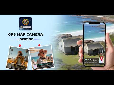
GPS Map Camera: Location lets you capture photos with accurate GPS location and time details. Add useful information like address, coordinates, and timestamps directly to your photos for better organization and reference.
Add Location & Time to Photos
Automatically add GPS location to your photos
Show date, time, latitude, longitude, and address
Real-time geotagging with accurate data
Easy Photo Capture with GPS Data
Capture photos with location details instantly
Preview and adjust stamp before saving
Works smoothly for everyday use
Customizable Photo Stamps
Choose from multiple stamp layouts
Add location, time, and map details
Adjust format to fit your needs
Designed for Practical Use
Useful for travel, site visits, and documentation
Keep track of where and when photos were taken
Simple and clean interface
Additional Features
Map view with photo location
Save and manage geotagged photos
Lightweight and easy to use
Updated on
Safety starts with understanding how developers collect and share your data. Data privacy and security practices may vary based on your use, region, and age. The developer provided this information and may update it over time.

No data shared with third parties
Learn more about how developers declare sharing

No data collected
Learn more about how developers declare collection

Data is encrypted in transit
Everyone
Learn moreApp support
About the developer
Ammad Qazi
tempcottageapp@gmail.com
73 Calverton Road
LUTON
LU3 2SY
United Kingdom


