Topografía básica
10K+
Downloads

Everyone
info
About this app
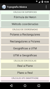
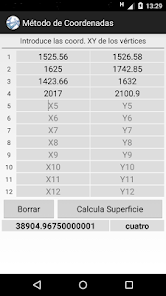
In calculating area can be obtained the surface of a triangle by the method of Heron and the surface of a polygon vertices 12 by the method of coordinates.
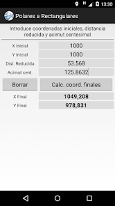
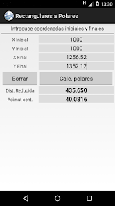
In COORDINATE CALCULATION we can move from polar coordinates to rectangular and vice versa. Also geographic coordinates UTM and vice versa.
In CALCULATIONS HEIGHTS results for altitudes, slopes and slopes are obtained.
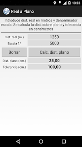
SCALE CALCULATIONS obtain in real or on the plane from an initial distance away. tolerance is also calculated.
CALCULATIONS GPS SMARTPHONE in the surface of a polygon vertices 12 is calculated by the method using the coordinate data obtained by the GPS mobile. enter 2-point distance is also calculated from GPS data. In both methods when GPS coordinates appear to be driving the Save button to remaining fixed point coordinates when it is considered that it is a final point. If any vertex data is lost can reload the data saved last time by the Load button. It is important to note that the surface or distance calculated by this method the accuracy obtained depends on the accuracy of GPS mobile device, so the final surface obtained always differ from the actual surface.
In COORDINATE CALCULATION we can move from polar coordinates to rectangular and vice versa. Also geographic coordinates UTM and vice versa.
In CALCULATIONS HEIGHTS results for altitudes, slopes and slopes are obtained.
SCALE CALCULATIONS obtain in real or on the plane from an initial distance away. tolerance is also calculated.
CALCULATIONS GPS SMARTPHONE in the surface of a polygon vertices 12 is calculated by the method using the coordinate data obtained by the GPS mobile. enter 2-point distance is also calculated from GPS data. In both methods when GPS coordinates appear to be driving the Save button to remaining fixed point coordinates when it is considered that it is a final point. If any vertex data is lost can reload the data saved last time by the Load button. It is important to note that the surface or distance calculated by this method the accuracy obtained depends on the accuracy of GPS mobile device, so the final surface obtained always differ from the actual surface.
Updated on
Safety starts with understanding how developers collect and share your data. Data privacy and security practices may vary based on your use, region and age The developer provided this information and may update it over time.

No data shared with third parties
Learn more about how developers declare sharing

No data collected
Learn more about how developers declare collection
What's new
- Se han añadido cálculos con altitudes, desniveles y pendientes.