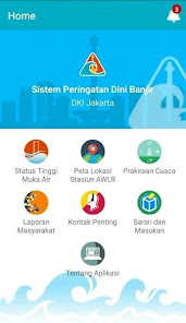
Sistem Peringatan Dini Banjir
10K+
Downloads

Everyone
info


About this app
Application features:
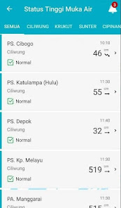
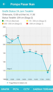
1. Displays information on the water level of rivers in Jakarta
2. Displays water level graph information for the last 24 hours
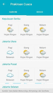
3. Displays weather forecast information for the Jabodetabek area (Data from BMKG)
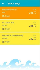
4. Provide notification regarding the alert status of the floodgate
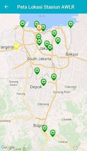
Water Level Monitoring Location:
Ciliwung River:
1. PS. Cibogo (Bogor)
2. PS. Katulampa (Bogor)
3. PS. Kampung Melayu
4. PS. Depok
5. PS. Manggarai
6. PA. Liberty
7. PA. Red Bridge
8. PA. Ancol Flushing
Pesanggrahan River:
1. PS. Sawangan
Sunter River:
1. PA. Pulo Gadung
2. PS. Sunter Hulu
3. PA. Yos Sudarso 1
Sea TMA:
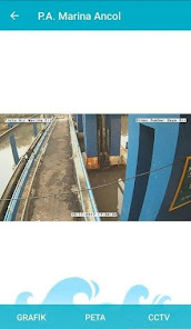
1. PA. Marina Ancol
2. PA. Tanjungan
3. PA. The fish market
Krukut River:
1. PS. Upper Crutches
2. Cideng Pump
Other:
1. PA. Hek (Kali Baru Timur)
2. PA. Karet (West Flood Canal)
3. PS. Marunda (East Flood Canal)
4. PS. Cipinang Hulu
5. PA. Angke Hulu
6. Kali Duri Pump (Kalijodo)
1. Displays information on the water level of rivers in Jakarta
2. Displays water level graph information for the last 24 hours
3. Displays weather forecast information for the Jabodetabek area (Data from BMKG)
4. Provide notification regarding the alert status of the floodgate
Water Level Monitoring Location:
Ciliwung River:
1. PS. Cibogo (Bogor)
2. PS. Katulampa (Bogor)
3. PS. Kampung Melayu
4. PS. Depok
5. PS. Manggarai
6. PA. Liberty
7. PA. Red Bridge
8. PA. Ancol Flushing
Pesanggrahan River:
1. PS. Sawangan
Sunter River:
1. PA. Pulo Gadung
2. PS. Sunter Hulu
3. PA. Yos Sudarso 1
Sea TMA:
1. PA. Marina Ancol
2. PA. Tanjungan
3. PA. The fish market
Krukut River:
1. PS. Upper Crutches
2. Cideng Pump
Other:
1. PA. Hek (Kali Baru Timur)
2. PA. Karet (West Flood Canal)
3. PS. Marunda (East Flood Canal)
4. PS. Cipinang Hulu
5. PA. Angke Hulu
6. Kali Duri Pump (Kalijodo)
Updated on
Safety starts with understanding how developers collect and share your data. Data privacy and security practices may vary based on your use, region, and age. The developer provided this information and may update it over time.

No data shared with third parties
Learn more about how developers declare sharing

No data collected
Learn more about how developers declare collection
What's new
Menambahkan Informasi Tampilan Curah Hujan
Menambahkan No Urut Pada alat AWLR dan ARR
Menambahkan Filter Daftar ARR
Menambahkan FIlter Daftar CCTV
Menambahkan Permission Challenge pada API 33
Memperbaiki Link Media Sosial dan Kontak Penting
Menyesuaikan Icon dan Warna Sesuai Standar
Mengubah warna font agar mudah dibaca
Melakukan Perbaikan Pada Laporan Masyarakat
Menambahkan Menu Curah Hujan Ekstrim