
Trainsity Bangkok BTS MRT
Contient des annonces
2,9star
219 avis
50 k+
Téléchargements

Tout public
info


À propos de l'application
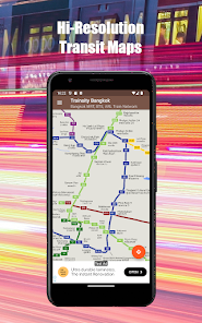
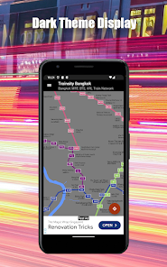
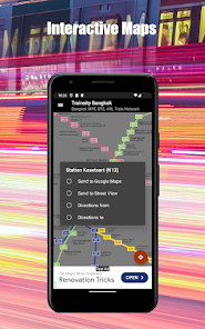
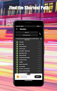
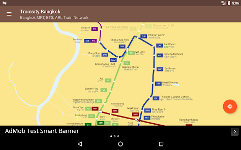
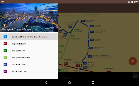
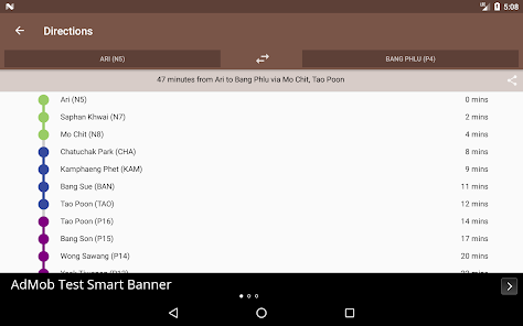
Parcourez la ville de Bangkok en utilisant les cartes vectorielles haute résolution du réseau de trains BTS, MRT Blue, MRT Purple et Airport Rail Link. Les cartes ont de petites empreintes de taille de fichier, mais avec de nombreux niveaux de zoom, et peuvent fonctionner hors connexion sans connexion à Internet. Les utilisateurs peuvent cliquer sur les étiquettes de la gare pour ouvrir Google Maps ou Google Street View, où ils peuvent utiliser toutes les fonctions des applications Google pour visualiser la région environnante et / ou effectuer un routage. Il existe également une fonction hors ligne permettant de calculer le meilleur moyen de transport d'une station à une autre avec une répartition de la direction et des horaires (pouvant varier du temps de trajet réel).
* Maintenant avec le mode thème sombre optionnel.
Langues anglaise et thaïlandaise (du mieux que je peux) incluses.
* Maintenant avec le mode thème sombre optionnel.
Langues anglaise et thaïlandaise (du mieux que je peux) incluses.
Date de mise à jour
La sécurité, c'est d'abord comprendre comment les développeurs collectent et partagent vos données. Les pratiques concernant leur confidentialité et leur protection peuvent varier selon votre utilisation, votre région et votre âge. Le développeur a fourni ces informations et peut les modifier ultérieurement.

Aucune donnée partagée avec des tiers
En savoir plus sur la manière dont les développeurs déclarent le partage

Aucune donnée collectée
En savoir plus sur la manière dont les développeurs déclarent la collecte

Les données sont chiffrées lors de leur transfert

Impossible de supprimer les données
Notes et avis
3,0
198 avis
Nouveautés
Adjust formatting of transit map.


