
Dotori GPS Tracker
Contains ads


Everyone
info
1+
Downloads


About this app
Save places to find again, record your route and count steps during a trip. Dotori GPS Tracker combines maps, location sharing, journey records and GPS tools. Your records stay on your phone.
MAPS AND PLACE SEARCH
- Download optional South Korean hiking trails and contour lines to display on the map.
- Zoom in for 20 m contours, with thick lines and altitude labels every 100 m.
- Download regional place and business data for offline name search, including Korean initial letters. Online address search is also available.
SAVE PLACES AND FIND YOUR WAY BACK
- Save your position with a note and a category such as parking or sights.
- A return compass shows direction and straight-line distance. Parking places have a My car action.
- Open points or directions in compatible external map apps.
SHARE A LOCATION, LET THE RECIPIENT CHOOSE THE MAP
- Send a location link. The recipient opens the shared page and chooses the map app they use.
- On Android, choices include KakaoMap, NAVER Map, TMAP and Google Maps, subject to installation and availability.
- Choose whether to include a note, or copy the coordinates and link.
PHOTO LOCATIONS
- Choose photos with the Android system photo picker and view their recorded shooting locations. Filter the selected photos by shooting dates, file names or nearby location. Available on supported Android versions; photos are processed on your device.
RECORD ROUTES AND STEPS
- Record by time, distance, or both conditions together.
- A trip you start can continue with the screen off. Pause, resume or finish from the app or notification.
- Enable Record steps to save phone-sensor step counts with that trip. Physical activity permission is requested when needed.
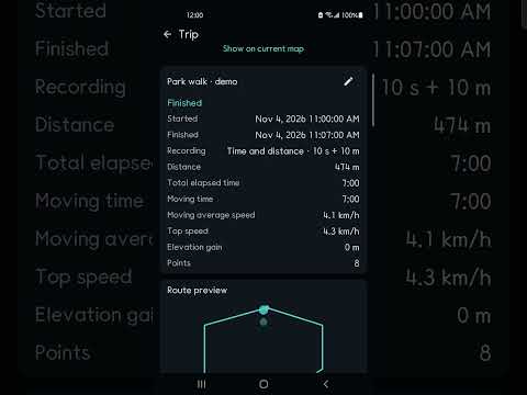
- Review distance, elapsed and moving time, average and maximum speed, ascent and your route on the map.
SPEEDOMETER AND HUD
- View large GPS speed digits or use the mirrored HUD.
- Supports portrait and landscape rotation and digit sizes. Vibrates above a speed threshold you set.
- The full-screen HUD hides ads. The threshold is your setting, not an automatic road speed-limit service.
119 LOCATION MESSAGE
- Prepare a message to South Korea's 119 with coordinates, a calculated national grid reference, accuracy and fix time.
- Add incident details and send it yourself in your messaging app. There is no automatic sending or confirmation of assistance.
YOUR RECORDS AND GPS TOOLS
- Keep records locally without an account. Search notes and trip titles.
- Back up records and step counts to JSON. Restoring replaces existing records after confirmation.
- Check accuracy, altitude and satellite signals. View or enter decimal coordinates, degrees-minutes-seconds and Plus Codes.
LOAD AND FOLLOW A SHARED ROUTE
- Import a route file (GPX), record while following it and receive vibration alerts for sustained deviation.
- Save or share your journey and waypoints as a route file. GPX does not include step counts.
Location permission is required. Step recording needs a supported sensor; physical activity permission is requested where needed. It counts during a trip, not all day automatically. Screen-off recording depends on device settings, power saving and reception. Recording does not restart automatically after reboot or force stop.
The base map and online search need internet. Downloaded search, trail and contour data can be read offline. Korean trail sources mainly date from 2016-2019 and do not cover every trail or current closures. Contours use satellite surface heights. The return compass shows a straight-line direction, not a walkable route. GPS, speed and steps can have errors. This is not an emergency, safety or professional surveying service.
Banner ads may appear. Map and advertising providers apply their own data practices. GPS records, notes and steps are not added to advertising requests. External maps, sharing and export pass selected content to the destination you choose.
MAPS AND PLACE SEARCH
- Download optional South Korean hiking trails and contour lines to display on the map.
- Zoom in for 20 m contours, with thick lines and altitude labels every 100 m.
- Download regional place and business data for offline name search, including Korean initial letters. Online address search is also available.
SAVE PLACES AND FIND YOUR WAY BACK
- Save your position with a note and a category such as parking or sights.
- A return compass shows direction and straight-line distance. Parking places have a My car action.
- Open points or directions in compatible external map apps.
SHARE A LOCATION, LET THE RECIPIENT CHOOSE THE MAP
- Send a location link. The recipient opens the shared page and chooses the map app they use.
- On Android, choices include KakaoMap, NAVER Map, TMAP and Google Maps, subject to installation and availability.
- Choose whether to include a note, or copy the coordinates and link.
PHOTO LOCATIONS
- Choose photos with the Android system photo picker and view their recorded shooting locations. Filter the selected photos by shooting dates, file names or nearby location. Available on supported Android versions; photos are processed on your device.
RECORD ROUTES AND STEPS
- Record by time, distance, or both conditions together.
- A trip you start can continue with the screen off. Pause, resume or finish from the app or notification.
- Enable Record steps to save phone-sensor step counts with that trip. Physical activity permission is requested when needed.
- Review distance, elapsed and moving time, average and maximum speed, ascent and your route on the map.
SPEEDOMETER AND HUD
- View large GPS speed digits or use the mirrored HUD.
- Supports portrait and landscape rotation and digit sizes. Vibrates above a speed threshold you set.
- The full-screen HUD hides ads. The threshold is your setting, not an automatic road speed-limit service.
119 LOCATION MESSAGE
- Prepare a message to South Korea's 119 with coordinates, a calculated national grid reference, accuracy and fix time.
- Add incident details and send it yourself in your messaging app. There is no automatic sending or confirmation of assistance.
YOUR RECORDS AND GPS TOOLS
- Keep records locally without an account. Search notes and trip titles.
- Back up records and step counts to JSON. Restoring replaces existing records after confirmation.
- Check accuracy, altitude and satellite signals. View or enter decimal coordinates, degrees-minutes-seconds and Plus Codes.
LOAD AND FOLLOW A SHARED ROUTE
- Import a route file (GPX), record while following it and receive vibration alerts for sustained deviation.
- Save or share your journey and waypoints as a route file. GPX does not include step counts.
Location permission is required. Step recording needs a supported sensor; physical activity permission is requested where needed. It counts during a trip, not all day automatically. Screen-off recording depends on device settings, power saving and reception. Recording does not restart automatically after reboot or force stop.
The base map and online search need internet. Downloaded search, trail and contour data can be read offline. Korean trail sources mainly date from 2016-2019 and do not cover every trail or current closures. Contours use satellite surface heights. The return compass shows a straight-line direction, not a walkable route. GPS, speed and steps can have errors. This is not an emergency, safety or professional surveying service.
Banner ads may appear. Map and advertising providers apply their own data practices. GPS records, notes and steps are not added to advertising requests. External maps, sharing and export pass selected content to the destination you choose.
Trail maps, location sharing, trip steps, speedometer and mirror HUD.
Updated on
Safety starts with understanding how developers collect and share your data. Data privacy and security practices may vary based on your use, region, and age. The developer provided this information and may update it over time.


What’s new
Explore your route with synchronized speed, elevation and steps-per-minute graphs. Drag any graph or the shared slider, or use the arrows to move one point at a time. Improved landscape layout and selected-point visibility.
App support
About the developer
곽종근
hugemail2me@gmail.com
South Korea


