
Drone Amplified
1K+
Downloads

Everyone
info


About this app
Beta Version: Try this out for free!
WE WANT YOUR FEEDBACK
Let us know what features you want, so we can make this app amplify your drone operations.
Features:
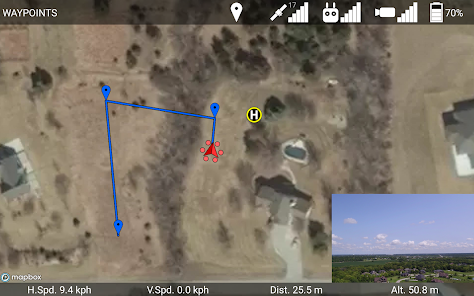
• Download elevation maps for terrain-aware flight
• Download satellite maps to fly without an internet connection.
• Touch the map to place waypoints, then upload them to the drone.
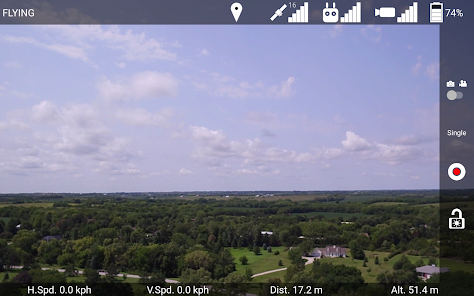
• Take photos and shoot video
• Adjust camera exposure, focus, digital zoom, and gimbal orientation
• View diagnostic information about the drone, and calibrate the compass.
• In-app manual.
• Overlay KMZ, KML, and Georeferenced PDF files on the map.
• And more!
Compatible with:
Inspire 1, Pro, Raw
Inspire 2
Matrice 100
Matrice 600, Pro
Phantom 3 Standard, 4K, Professional, Advanced
Phantom 4, Pro, Advanced
Mavic Air, Pro
Mavic 2 Pro, Zoom
Manual:
http://droneamplified.com/app/AppManual.pdf
Release Notes:
http://droneamplified.com/downloads/android/App_Release_Notes.pdf
Request features, report bugs, or contact us at:
appdev@droneamplified.com
If you find a bug that causes the app to crash, please email the crash report in Drone Amplified/Crash Reports/ to this email.
WE WANT YOUR FEEDBACK
Let us know what features you want, so we can make this app amplify your drone operations.
Features:
• Download elevation maps for terrain-aware flight
• Download satellite maps to fly without an internet connection.
• Touch the map to place waypoints, then upload them to the drone.
• Take photos and shoot video
• Adjust camera exposure, focus, digital zoom, and gimbal orientation
• View diagnostic information about the drone, and calibrate the compass.
• In-app manual.
• Overlay KMZ, KML, and Georeferenced PDF files on the map.
• And more!
Compatible with:
Inspire 1, Pro, Raw
Inspire 2
Matrice 100
Matrice 600, Pro
Phantom 3 Standard, 4K, Professional, Advanced
Phantom 4, Pro, Advanced
Mavic Air, Pro
Mavic 2 Pro, Zoom
Manual:
http://droneamplified.com/app/AppManual.pdf
Release Notes:
http://droneamplified.com/downloads/android/App_Release_Notes.pdf
Request features, report bugs, or contact us at:
appdev@droneamplified.com
If you find a bug that causes the app to crash, please email the crash report in Drone Amplified/Crash Reports/ to this email.
Updated on
Safety starts with understanding how developers collect and share your data. Data privacy and security practices may vary based on your use, region, and age. The developer provided this information and may update it over time.

No data shared with third parties
Learn more about how developers declare sharing

This app may collect these data types
Location

Data is encrypted in transit

Data can’t be deleted
What's new
Added altitude above MSL ( from inputted takeoff location elevation) option.