
Ignis
100+
ଡାଉନଲୋଡଗୁଡ଼ିକ

ସମସ୍ତେ
info


ଏହି ଆପ୍ ବିଷୟରେ
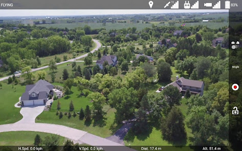
The Ignis app allows you to control the flight of a DJI Matrice 600 drone and the operation of IGNIS to easily and safely ignite prescribed fires.
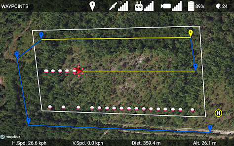
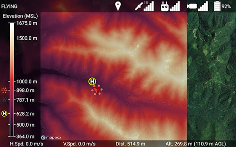
Download elevation maps for terrain-aware flights
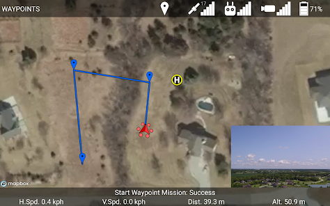
Automatically takeoff, fly along waypoints, drop ignition spheres, and land.
Set a geofence to ensure ignition only occurs within the burn area.
About Ignis:
http://droneamplified.com/
Manual:
http://www.droneamplified.com/downloads/IgnisManual.pdf
Release Notes:
http://droneamplified.com/downloads/android/App_Release_Notes.pdf
Request features, report bugs, or contact us at:
appdev@droneamplified.com
Download elevation maps for terrain-aware flights
Automatically takeoff, fly along waypoints, drop ignition spheres, and land.
Set a geofence to ensure ignition only occurs within the burn area.
About Ignis:
http://droneamplified.com/
Manual:
http://www.droneamplified.com/downloads/IgnisManual.pdf
Release Notes:
http://droneamplified.com/downloads/android/App_Release_Notes.pdf
Request features, report bugs, or contact us at:
appdev@droneamplified.com
ଗତ ଅପଡେଟର ସମୟ
ଡେଭେଲପରମାନେ ଆପଣଙ୍କ ଡାଟାକୁ କିପରି ସଂଗ୍ରହ ଏବଂ ସେୟାର କରନ୍ତି ସେହି ଧାରଣା ସହିତ ସୁରକ୍ଷା ଆରମ୍ଭ ହୁଏ। ଆପଣଙ୍କ ବ୍ୟବହାର, ଅଞ୍ଚଳ ଏବଂ ବୟସ ଆଧାରରେ, ଡାଟା ଗୋପନୀୟତା ଓ ସୁରକ୍ଷା କାର୍ଯ୍ୟପଦ୍ଧତିଗୁଡ଼ିକ ଭିନ୍ନ ହୋଇପାରେ। ଡେଭେଲପର ଏହି ସୂଚନା ପ୍ରଦାନ କରିଛନ୍ତି ଏବଂ ସେ ସମୟାନୁସାରେ ଏହାକୁ ଅପଡେଟ କରିପାରନ୍ତି।

ତୃତୀୟ ପକ୍ଷଗୁଡ଼ିକ ସହ କୌଣସି ଡାଟା ସେୟାର କରାଯାଇନାହିଁ
ଡେଭେଲପରମାନେ କିପରି ସେୟାରିଂର ଘୋଷଣା କରନ୍ତି ସେ ବିଷୟରେ ଅଧିକ ଜାଣନ୍ତୁ

ଏହି ଆପ ଏଇ ଡାଟା ପ୍ରକାରଗୁଡ଼ିକ ସଂଗ୍ରହ କରିପାରେ
ଲୋକେସନ

ଟ୍ରାଞ୍ଜିଟ ସମୟରେ ଡାଟା ଏନକ୍ରିପ୍ଟ କରାଯାଇଥାଏ

ଡାଟା ଡିଲିଟ କରାଯାଇପାରିବ ନାହିଁ
ନୂଆ କଣ ଅଛି
Added Altitude above Mean Sea Level (from inputted takeoff location elevation) option.