Camin de los Santuarios
1K+
Downloads

Everyone
info


About this app
Camin de los Santuarios is the FREE application that will help you on your journey along this interesting route proposed by the Ministry of Culture, Language Policy and Tourism of the Principality of Asturias.
Walk and discover this very important cultural and historical itinerary that links the Cathedral of Oviedo with the monastery of Santo Toribio de Liebana, passing through the Royal Site of Covadonga.
A route full of historical monuments, ranging from prehistoric remains to different constructions dating from different periods, with pre-Romanesque, Romanesque, Renaissance or Baroque examples.
You will also enjoy spaces of great landscape, ethnographic and natural value, members of the Natura 2000 Network.
Camin de los Santuarios is called to be a reference of the first order within the European cultural itineraries.
Our App will help you on your journey along the Camin. Is a multilanguage aplication, currently available in English, Spanish and French.
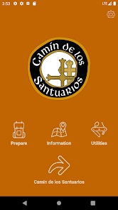
Camin de los Santuarios offers you:
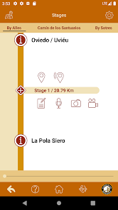
- You can plan the trip, learn about the different itineraries, check all kind of information about the stages, distances, profiles and points of interest.
- Our small guide with “Basic Tips” to prepare you for the Camin will help you with the planning and equipment. The app offers you written and voice notes so you can project in advance what would you want to do, visit or buy at every stage. You can transfer all the information to the application so you can recall it during your journey.
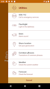
- Security: you can share or send to family and friends your GPS geolocation at any time, or use the SOS button for make a direct call to 112 emergency Spain.
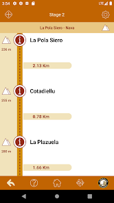
- You can keep on your journey through a “Subway Style” map which offers you complimentary information about the itinerary, stages and locations, as well as access to other “Subway Style” maps about the particular stages.
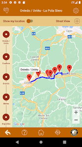
- You will have access to maps and Offline profiles (no data connection required) of each stage, as well as Online maps (requires data connection) to provide bigger accuracy during your journey. In the Offline maps you will have GPS positioning without Internet connection, if your device has GPS.
- You can also have a journey log in which you can add text notes, voice notes, photos and videos during your trip, or recall all the information that you have already added during the preparation of your Camin.
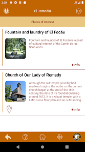
- Geolocation of the points of interest.
- When you have finished, you can recreate your experience since everything you wanted to remember about your way will be reflected in your written notes, voice, video and pictures.
- You can access real-time weather information and forecasts.
- Multilingual dictionary with common phrases translated into Spanish. You can read them from the phone or the application can verbalize them for you.
- You can share your experience in social networks, sharing photos and places that you are visiting.
- Utilities section: Siren, Flashlight, Share location, Common phrases, Weather and Forecast, Compass, ...
- Quick access to the most important utilities from the bottom bar.
With Camin de los Santuarios you will fully enjoy this important historical and unique route.
Walk and discover this very important cultural and historical itinerary that links the Cathedral of Oviedo with the monastery of Santo Toribio de Liebana, passing through the Royal Site of Covadonga.
A route full of historical monuments, ranging from prehistoric remains to different constructions dating from different periods, with pre-Romanesque, Romanesque, Renaissance or Baroque examples.
You will also enjoy spaces of great landscape, ethnographic and natural value, members of the Natura 2000 Network.
Camin de los Santuarios is called to be a reference of the first order within the European cultural itineraries.
Our App will help you on your journey along the Camin. Is a multilanguage aplication, currently available in English, Spanish and French.
Camin de los Santuarios offers you:
- You can plan the trip, learn about the different itineraries, check all kind of information about the stages, distances, profiles and points of interest.
- Our small guide with “Basic Tips” to prepare you for the Camin will help you with the planning and equipment. The app offers you written and voice notes so you can project in advance what would you want to do, visit or buy at every stage. You can transfer all the information to the application so you can recall it during your journey.
- Security: you can share or send to family and friends your GPS geolocation at any time, or use the SOS button for make a direct call to 112 emergency Spain.
- You can keep on your journey through a “Subway Style” map which offers you complimentary information about the itinerary, stages and locations, as well as access to other “Subway Style” maps about the particular stages.
- You will have access to maps and Offline profiles (no data connection required) of each stage, as well as Online maps (requires data connection) to provide bigger accuracy during your journey. In the Offline maps you will have GPS positioning without Internet connection, if your device has GPS.
- You can also have a journey log in which you can add text notes, voice notes, photos and videos during your trip, or recall all the information that you have already added during the preparation of your Camin.
- Geolocation of the points of interest.
- When you have finished, you can recreate your experience since everything you wanted to remember about your way will be reflected in your written notes, voice, video and pictures.
- You can access real-time weather information and forecasts.
- Multilingual dictionary with common phrases translated into Spanish. You can read them from the phone or the application can verbalize them for you.
- You can share your experience in social networks, sharing photos and places that you are visiting.
- Utilities section: Siren, Flashlight, Share location, Common phrases, Weather and Forecast, Compass, ...
- Quick access to the most important utilities from the bottom bar.
With Camin de los Santuarios you will fully enjoy this important historical and unique route.
Updated on
Safety starts with understanding how developers collect and share your data. Data privacy and security practices may vary based on your use, region, and age. The developer provided this information and may update it over time.

No data shared with third parties
Learn more about how developers declare sharing

No data collected
Learn more about how developers declare collection
What's new
Data update.
Data correction.
Data correction.
