Alerta Vale do Itajaí
Contains adsIn-app purchases
1K+
Downloads

Everyone
info
About this app
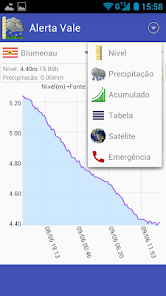
Worried about rains, storms and floods? AlertaVale allows you to monitor in real time the rainfall (rainfall) and the level of rivers in the Itajaí Valley - Santa Catarina. Alert Vale uses data from the CEOPS / FURB, which monitors the level of rivers in real time. In addition, Vale Alert shows the current trend of rivers (whether they are rising, falling, or stable) and also the current situation / state (normal, alert, attention, or emergency).
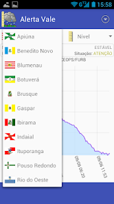
Currently, Vale Alert allows you to view data and graphs of the following cities in the Vale do Itajaí region:
Apiúna, Benedito Novo, Blumenau, Botuverá, Brusque, Gaspar, Ibirama, Indaial, Ituporanga, Pouso Redondo, Rio do Oeste, Rio dos Cedros, Rio do Sul, Taió, Timbó, Vidal Ramos
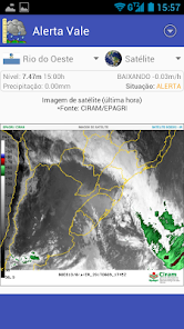
Other features of the Vale do Itajaí Alert are the possibility to view satellite photos from the last hour, published by CIRAM / EPAGRI, and emergency phones.
If you keep the app open, it will show an update button every 5 minutes, but usually new data updates are available every 15 minutes.
⚠️ ATTENTION ⚠️ The Vale do Itajaí Alert app will only show river level data if there is updated information. When we are not in the rainy season, the sensors are often also turned off. In these cases, you can still view satellite images in real time. To do this, just select the option "Satellite".
Highlights
- See the trend of rivers in real time;
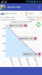
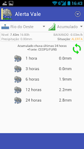
- See the level of the rivers now and graph of the level of the rivers of the last 24 hours;
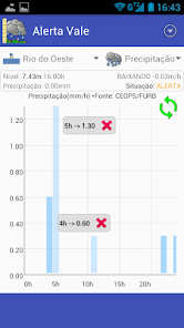
- See the precipitation that occurred hourly in the last 24 hours;
- Touch the graphs to get more information about the measurements;
- Zoom and move the graphics sideways or up / down, as you prefer;
- See the accumulated rainfall of the last 24 hours;
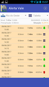
- See the complete table of measurements and rainfall for the last 24 hours;
- See the satellite photo from the last hour (source CIRAM / EPAGRI);
- Zoom and drag the satellite image;
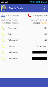
- See emergency phones, such as firefighters, SAMU, civil defense and CELESC;
- Simple and intuitive visual;
- Updates of information in real time;
Currently, Vale Alert allows you to view data and graphs of the following cities in the Vale do Itajaí region:
Apiúna, Benedito Novo, Blumenau, Botuverá, Brusque, Gaspar, Ibirama, Indaial, Ituporanga, Pouso Redondo, Rio do Oeste, Rio dos Cedros, Rio do Sul, Taió, Timbó, Vidal Ramos
Other features of the Vale do Itajaí Alert are the possibility to view satellite photos from the last hour, published by CIRAM / EPAGRI, and emergency phones.
If you keep the app open, it will show an update button every 5 minutes, but usually new data updates are available every 15 minutes.
⚠️ ATTENTION ⚠️ The Vale do Itajaí Alert app will only show river level data if there is updated information. When we are not in the rainy season, the sensors are often also turned off. In these cases, you can still view satellite images in real time. To do this, just select the option "Satellite".
Highlights
- See the trend of rivers in real time;
- See the level of the rivers now and graph of the level of the rivers of the last 24 hours;
- See the precipitation that occurred hourly in the last 24 hours;
- Touch the graphs to get more information about the measurements;
- Zoom and move the graphics sideways or up / down, as you prefer;
- See the accumulated rainfall of the last 24 hours;
- See the complete table of measurements and rainfall for the last 24 hours;
- See the satellite photo from the last hour (source CIRAM / EPAGRI);
- Zoom and drag the satellite image;
- See emergency phones, such as firefighters, SAMU, civil defense and CELESC;
- Simple and intuitive visual;
- Updates of information in real time;
Updated on
Safety starts with understanding how developers collect and share your data. Data privacy and security practices may vary based on your use, region, and age. The developer provided this information and may update it over time.

No data shared with third parties
Learn more about how developers declare sharing

No data collected
Learn more about how developers declare collection
What's new
- Criada versão PREMIUM, que remove publicidade do aplicativo, deixando-o ainda mais leve e rápido, além de evitar consumo de Internet ao carregar publicidade. Ela pode ser habilitada diretamente no menu principal do aplicativo.


