
FSV APP


Everyone
info
500+
Downloads

Everyone
Learn more


About this app
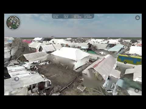
An application for:
- Enhancing situational awareness
- Tactical planning
- Personnel training
- UGV control.
FSV App:
- Utilizes 3D models generated on the FSV Platform.
- Enables precise shooting range calculations, UAV flight path calculations, fire card development, and strategic assessments.
- Helps identify blind spots, determine optimal target points, analyze high-risk routes, and plan optimal evacuation paths.
- Integrates with ATAK for real-time object tracking.
Updated on
Safety starts with understanding how developers collect and share your data. Data privacy and security practices may vary based on your use, region, and age. The developer provided this information and may update it over time.

No data shared with third parties
Learn more about how developers declare sharing

This app may collect these data types
Location, Personal info and 3 others

Data is encrypted in transit

Data can’t be deleted
What’s new
New Features
• Added the ability to restart failed uploads.
• Fixed font display issues in upload and 3D model lists/maps.
• Restricted app access for expired users.
• Duplicate processing names are now detected before processing starts.
• The LiDAR tool is now available through workspace permissions.
• Improved LiDAR runtime path visualization.
• Fixed errors caused by repeatedly clicking New/Restart Upload.
Everyone
Learn moreApp support
phone
Phone number
+380634435983
About the developer
FarsightVision OU
contact@farsightvision.com
Telliskivi tn 60a/5
10412 Tallinn
Estonia
+380 97 749 3848