Fishing Status
Achats via l'appli
4,4star
7 avis
1K+
Téléchargements

Tout public
info
À propos de l'application
Fishing Status has the best fishing forecast, fishing spots, fishing reports, fishing maps, and fishing related data to catch more fish. Whether you fish the local lake or 100 miles offshore, we have all of the fishing information to plan the perfect trip.
Fishing Status has the words largest online database of fishing information. Now you can get all of the best fishing information for your area all in one place. Here are a few of our statistics:
7+ Billion Fish Counted
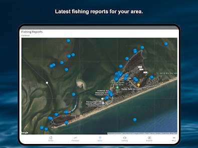
3+ Million Fishing Reports
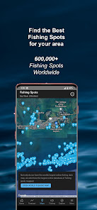
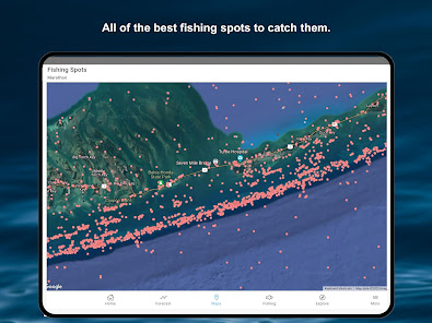
1+ Million Fishing Spots
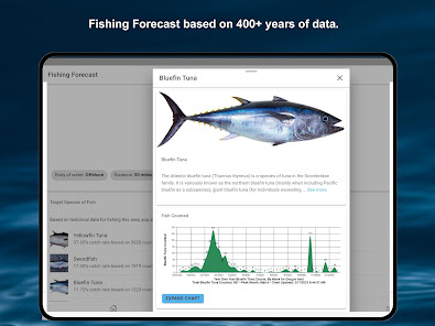
400+ Years of Data (since 1/1/1600)
You can post fishing reports and fishing spots. Keep track of fishing activity from multiple areas with Favorites, allowing quick access to fishing forecast, fishing spots, and fishing reports.
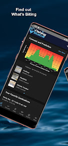
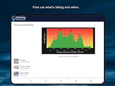
We are taking the mystery out of what is biting and when, showing the migrations of fish, and their patterns, combining geospatial scientific data collections for numerous sources.as well as the aggregated, and generously donated reports from our many users. With historical and predictive charts, you can target fish species as their yearly migration passes through your favorite areas. Don't miss the bite!
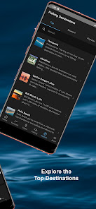
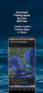
We have the world's largest database of fishing spots with over 1,200,000 spots worldwide. We have added the ability to download fishing spots for your mobile device, or your GPS unit on your boat. We provide the files that allow you to import them directly into your navigation unit. We also allow you to create your own custom maps of fishing spots with filters for distance, structure, and more. We have 100 mile radius saltwater maps and 30 mile lake maps of fishing spots that are updated bi-monthly and available for download for mobile and many GPS units.
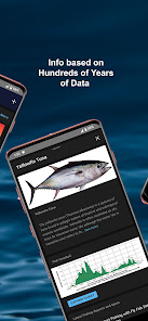
We also have species of fish heatmaps/distribution maps that show you exactly where to catch them. Using hundreds of years of data we show heatmaps over satellite images to show where the fish are. You can also animate each month to show how each fish migrates. Save time and money by fishing where the fish are and not where they might be.
We are constantly adding more data and updating the app with new features.
Fishing Status has the words largest online database of fishing information. Now you can get all of the best fishing information for your area all in one place. Here are a few of our statistics:
7+ Billion Fish Counted
3+ Million Fishing Reports
1+ Million Fishing Spots
400+ Years of Data (since 1/1/1600)
You can post fishing reports and fishing spots. Keep track of fishing activity from multiple areas with Favorites, allowing quick access to fishing forecast, fishing spots, and fishing reports.
We are taking the mystery out of what is biting and when, showing the migrations of fish, and their patterns, combining geospatial scientific data collections for numerous sources.as well as the aggregated, and generously donated reports from our many users. With historical and predictive charts, you can target fish species as their yearly migration passes through your favorite areas. Don't miss the bite!
We have the world's largest database of fishing spots with over 1,200,000 spots worldwide. We have added the ability to download fishing spots for your mobile device, or your GPS unit on your boat. We provide the files that allow you to import them directly into your navigation unit. We also allow you to create your own custom maps of fishing spots with filters for distance, structure, and more. We have 100 mile radius saltwater maps and 30 mile lake maps of fishing spots that are updated bi-monthly and available for download for mobile and many GPS units.
We also have species of fish heatmaps/distribution maps that show you exactly where to catch them. Using hundreds of years of data we show heatmaps over satellite images to show where the fish are. You can also animate each month to show how each fish migrates. Save time and money by fishing where the fish are and not where they might be.
We are constantly adding more data and updating the app with new features.
Date de mise à jour
La sécurité, c'est d'abord comprendre comment les développeurs collectent et partagent vos données. Les pratiques concernant leur confidentialité et leur protection peuvent varier selon votre utilisation, votre région et votre âge. Le développeur a fourni ces informations et peut les modifier ultérieurement.

Cette appli peut partager ces types de données avec des tiers
Informations financières, Appareil ou autres ID

Cette appli peut recueillir ces types de données
Informations personnelles, Photos et vidéos, Appareil ou autres ID

Les données sont chiffrées lors de leur transfert

Vous pouvez demander la suppression des données
Nouveautés
Improvements in heatmaps and fix for recording and saving trips.