
Ski Haute-Gaspésie
In-app purchases
4.2star
11 reviews
1K+
Downloads

Everyone
info
About this app
The Ski Haute-Gaspésie application is presented by Avalanche Québec. This application is an essential to have with you to plan your day on the mountain and navigate in the Chic-Chocs and Haute-Gaspésie. Have Ski Haute-Gaspésie at your fingertips offers you:
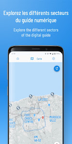
The electronic guide of the Chic-Chocs itinerary including:
- A precise topographic map with avalanche terrain exposure scale ratings;
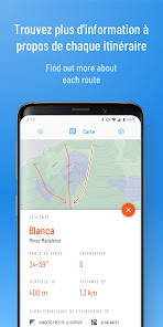
- The ascents and runs routes with information on them (name, difficulty level, elevation gain, characteristics and photos);
- Your position in real time on the map using your cell phone's GPS;
- The possibility to download the maps for offline use;
- And all the information contained in the Chic-Chocs guidebook.
All the information you need to plan your mountain trip in one place:
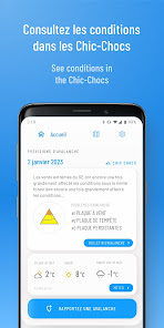
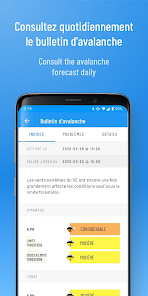
- The complete avalanche bulletin;
- Environment Canada's public weather forecast as well as the Chic-Chocs alpine weather forecast, and more;
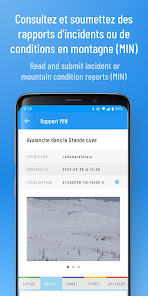
- Mountain Information Network reports on the map;
- Webcam, snow report and automated weather station data.
The electronic guide of the Chic-Chocs itinerary including:
- A precise topographic map with avalanche terrain exposure scale ratings;
- The ascents and runs routes with information on them (name, difficulty level, elevation gain, characteristics and photos);
- Your position in real time on the map using your cell phone's GPS;
- The possibility to download the maps for offline use;
- And all the information contained in the Chic-Chocs guidebook.
All the information you need to plan your mountain trip in one place:
- The complete avalanche bulletin;
- Environment Canada's public weather forecast as well as the Chic-Chocs alpine weather forecast, and more;
- Mountain Information Network reports on the map;
- Webcam, snow report and automated weather station data.
Updated on
Safety starts with understanding how developers collect and share your data. Data privacy and security practices may vary based on your use, region, and age. The developer provided this information and may update it over time.

No data shared with third parties
Learn more about how developers declare sharing

No data collected
Learn more about how developers declare collection
Ratings and reviews
4.2
11 reviews

A Google user
- Flag inappropriate
- Show review history
January 29, 2020
Pretty nice mapping app..great showing the runs and uptracks and locating your position. Would be nice to be able to record your track and log the day eventually..or make the gpx file available for sale to use in Gaia maybe for the addede functionality. Will you be adding tracks for newly opened Ernest Laforce area?

André-Pierre Blanchard-Dionne
- Flag inappropriate
February 12, 2021
Les cartes "hors connexion" s'effacent lorsque je suis "hors connexion"
A Google user
- Flag inappropriate
February 11, 2020
La piste la creme de la creme #7 dans les Vallières n'est pas située à la bonne place par rapport au guide papier des chic-chocs. Dans l'application, la piste la crème de la crème est dans le même bowl que la sterling. Dans le livre, ces 2 pistes sont dans 2 bowls différents... ce serait à corriger. Merci!
What's new
Ski Haute-Gaspésie app is always improving. The third version will let you access, by subscribing, to exclusive features such as :
- The description of more than 130 skiing and skinning routes, including the characteristics of each one and photos ;
- Geolocation to assist your navigation ;
- Access to the last 24 hours of webcam images ;
- Access to the last 24 hours of mountain weather stations data.
- The description of more than 130 skiing and skinning routes, including the characteristics of each one and photos ;
- Geolocation to assist your navigation ;
- Access to the last 24 hours of webcam images ;
- Access to the last 24 hours of mountain weather stations data.