
Land Nav Assistant

star
341 reviews

Everyone
info
50K+
Downloads

Everyone
Learn more


About this app
Land Nav Assistant accepts MGRS (Military Grid) or Latitude / Longitude coordinates and visually navigates you to each point.
This app was designed with Army, Marine, and other military personnel in mind. Use it to correct your Land Nav technique by analyzing your pace count and tendency to veer left and right.
Available Input: 8 digit MGRS, 10 digit MGRS, Lat/Lon decimal, Lat/Lon dms, and map input.
Angles: degrees or mils
Distance: meters/km or feet/miles
Speed: kph or mph
Use the simple arrow interface or map to direct you to your locations. Your distance, direction, speed, and bearing are shown as you navigate.
Long-tap anywhere on the map to get the coordinate for that location. Easily add locations via the Map interface.
Plan your course by ordering points, or use the course optimization tool which will help you calculate the shortest path possible!
Get distance/direction between two points by tapping the path drawn between them.
Satellite, Terrain, Road, and basic Topographic maps show you, your locations, and lets you enter in new ones.
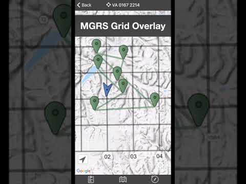
Overlay a 1000m or 100m MGRS grid anywhere on the map.
Displays distance/direction from your currentl location to all points, or between any two points.
Download your Locations as a spreadsheet to save anywhere, or to share with anyone you choose.
Import a large set of locations via the web import utility, available at: https://www.gammonapplications.com/land-navigation-services/import
This app uses the Military Grid Reference System (MGRS) and Latitude / Longitude.
Choose to display your locations as MGRS 10-digit, MGRS 8-digit, or LatLon Decimal.
D:M:S can be input in the format DD:MM:SS followed by the appropriate direction (NSWE). Default direction is N, W.
DO NOT use this application while learning Land Navigation. Land Navigation is a valuable skill, and should be mastered before using this application. Do not rely solely on this application for navigation, especially when lost. Always be aware of your surroundings.
This app was designed with Army, Marine, and other military personnel in mind. Use it to correct your Land Nav technique by analyzing your pace count and tendency to veer left and right.
Available Input: 8 digit MGRS, 10 digit MGRS, Lat/Lon decimal, Lat/Lon dms, and map input.
Angles: degrees or mils
Distance: meters/km or feet/miles
Speed: kph or mph
Use the simple arrow interface or map to direct you to your locations. Your distance, direction, speed, and bearing are shown as you navigate.
Long-tap anywhere on the map to get the coordinate for that location. Easily add locations via the Map interface.
Plan your course by ordering points, or use the course optimization tool which will help you calculate the shortest path possible!
Get distance/direction between two points by tapping the path drawn between them.
Satellite, Terrain, Road, and basic Topographic maps show you, your locations, and lets you enter in new ones.
Overlay a 1000m or 100m MGRS grid anywhere on the map.
Displays distance/direction from your currentl location to all points, or between any two points.
Download your Locations as a spreadsheet to save anywhere, or to share with anyone you choose.
Import a large set of locations via the web import utility, available at: https://www.gammonapplications.com/land-navigation-services/import
This app uses the Military Grid Reference System (MGRS) and Latitude / Longitude.
Choose to display your locations as MGRS 10-digit, MGRS 8-digit, or LatLon Decimal.
D:M:S can be input in the format DD:MM:SS followed by the appropriate direction (NSWE). Default direction is N, W.
DO NOT use this application while learning Land Navigation. Land Navigation is a valuable skill, and should be mastered before using this application. Do not rely solely on this application for navigation, especially when lost. Always be aware of your surroundings.
GPS MGRS & LatLng Navigation for Military and Outdoor enthusiasts
Updated on
Safety starts with understanding how developers collect and share your data. Data privacy and security practices may vary based on your use, region, and age. The developer provided this information and may update it over time.


Ratings and reviews
335 reviews

Jonathan Collazo
- Flag inappropriate
July 5, 2021
Bought this app for the little "reconnaissance patrol" my friend and I like to do every 4th of July. It worked great even having no signal out in the Tillamook forest of Oregon. I was able to set a nice route that followed the low ground using the included topographical map feature. My only grip with the app is that you can't select the actual course lines and move them at will to follow terrain features like a winding river. Would recommend overall!
29 people found this review helpful

Evan Bennion
- Flag inappropriate
September 2, 2026
Since the last update any time you close the app it completely resets back to first time use. all stored data and points delete and all settings return to default. paid for this app years ago and it has been made useless now.

Tyler Hanisch
- Flag inappropriate
November 14, 2022
This app is great. I use it for work almost every day. I ride an ATV for work and have to navigate trails for military training. The only thing I wish i could do is track my movement on trails and have it save on the map like the MGRS app as some trails are not on the map or show on the map but are actually overgrown and not drivable. If it had this feature i believe this app would be the only app worth using 100%
7 people found this review helpful
What’s new
- Support for newer Android devices
- Smoother, more accurate compass
- Headings no longer get stuck when you're standing still
- Fixed minor UI bugs
- Better screen-reader support for map and location controls
- Support emails now automatically include helpful device details, making it easier for us to help you
- Under-the-hood updates and performance improvements
- Smoother, more accurate compass
- Headings no longer get stuck when you're standing still
- Fixed minor UI bugs
- Better screen-reader support for map and location controls
- Support emails now automatically include helpful device details, making it easier for us to help you
- Under-the-hood updates and performance improvements
Everyone
Learn moreApp support
About the developer
GAMMON APPLICATIONS, LLC
support@gammonapplications.com
111 Woodcliff Ln
Rogers, AR 72756-0712
United States
+1 479-222-0586