
mKart Marine Navigation
Kupovina unutar aplikacije
3,5star
120 recenzija
10 hilj.+
Preuzimanja

Svako
info


O aplikaciji
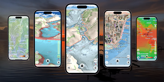
mKart is easy to install and use online marine navigation software (from creators of ECS/ECDIS dKart Navigator) with the fastest chart engine using hybrid ON/OFF sea maps concept and 3D nautical charts.
Product Highlights:
WEB CONSOLE:
E-shop;
ENCs and cartographic products Catalogue;
Portfolio optimization;
Fleet management;
Roots and tracks;
Data exchange;
Accounting;
SAFETY IS IN FOCUS:
Automatic routing and NO-GO Area display;
Dangerous depths and objects automatic control.
Safe sailing alternative and recommendations;
Meeting points and hazardous traverses calculations.
Background monitoring: dangers’ and ships’ alerts, all along the route.
Apple watch support.
DOCKING:
Click on the chart, select the location and follow the docking path.
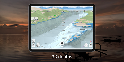
3D MARINE AND OSM CHARTS:
3D marine and OSM charts are uploaded and displayed automatically. 3D sea floor, land’s relief, 3D buildings, ships and infrastructure models contribute to better seafarers orientation and awareness.
FREE NOAA ENCs:
Online NOAA nautical charts are being installed automatically via Internet by customer’s position or while browsing and stored for off-line use. Updating is performed in the same way.
SMART PANELS:
Swipe from below and from side to side. Profiles of seabed relief, safety path simulator, docking.
MARINE ROUTE PLANNER:
Save time with integrated sea and river auto routes functionality. Safety checks is implemented along with route monitoring functionality and warning system.
NO GO ZONE:
Display safety area is filled up graphically on the sea map by only safe depth. Safety zone is calculated trough 3D sea bottom model.
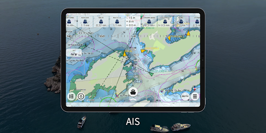
MARINE TRAFFIC:
Marine traffic data can be obtained from open AIS streams over Internet to display and identify dangerous targets.
COMPASS MODE:
Get a quick look around while boat navigation with advanced VR option for better orientation and using visual aids for navigation effectively.
SEARCH:
Search all objects and information on ENC S-57 charts trough SW and data via universal search function.
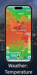
MARINE WEATHER:
mKart online services allows to deliver highly detailed weather information and forecast.
TRACKS AND WAYPOINTS:
PLT and WPT import and export, recording and displaying on the chart.
Product Highlights:
WEB CONSOLE:
E-shop;
ENCs and cartographic products Catalogue;
Portfolio optimization;
Fleet management;
Roots and tracks;
Data exchange;
Accounting;
SAFETY IS IN FOCUS:
Automatic routing and NO-GO Area display;
Dangerous depths and objects automatic control.
Safe sailing alternative and recommendations;
Meeting points and hazardous traverses calculations.
Background monitoring: dangers’ and ships’ alerts, all along the route.
Apple watch support.
DOCKING:
Click on the chart, select the location and follow the docking path.
3D MARINE AND OSM CHARTS:
3D marine and OSM charts are uploaded and displayed automatically. 3D sea floor, land’s relief, 3D buildings, ships and infrastructure models contribute to better seafarers orientation and awareness.
FREE NOAA ENCs:
Online NOAA nautical charts are being installed automatically via Internet by customer’s position or while browsing and stored for off-line use. Updating is performed in the same way.
SMART PANELS:
Swipe from below and from side to side. Profiles of seabed relief, safety path simulator, docking.
MARINE ROUTE PLANNER:
Save time with integrated sea and river auto routes functionality. Safety checks is implemented along with route monitoring functionality and warning system.
NO GO ZONE:
Display safety area is filled up graphically on the sea map by only safe depth. Safety zone is calculated trough 3D sea bottom model.
MARINE TRAFFIC:
Marine traffic data can be obtained from open AIS streams over Internet to display and identify dangerous targets.
COMPASS MODE:
Get a quick look around while boat navigation with advanced VR option for better orientation and using visual aids for navigation effectively.
SEARCH:
Search all objects and information on ENC S-57 charts trough SW and data via universal search function.
MARINE WEATHER:
mKart online services allows to deliver highly detailed weather information and forecast.
TRACKS AND WAYPOINTS:
PLT and WPT import and export, recording and displaying on the chart.
Ažurirano dana
Sigurnost počinje razumijevanjem na koji način programeri prikupljaju i dijele vaše podatke. Privatnost podataka i sigurnosne prakse se mogu razlikovati ovisno o korištenju, regiji i dobi. Programer je pružio ove informacije i može ih s vremenom ažurirati.

Podaci se ne dijele s trećim stranama
Saznajte više o načinu na koji programeri pružaju izjavu o dijeljenju

Ova aplikacija može prikupljati ove vrste podataka
Lokacija, Lične informacije i još 2

Podaci nisu šifrirani

Možete zatražiti da se podaci izbrišu
Ocjene i recenzije
3,4
113 recenzija
Šta ima novo
We have added the ability to purchase an ENC via the GetENC service to the app. Now buying a PRIMAR charts has become even faster and easier.


