GIS Mapper - Surveying App for
In-app purchases
1.8star
103 reviews
10K+
Downloads

Everyone
info


About this app
With the GNSS/GPS connection, GIS Mapper survey application is used for GIS data collection. This application is not only enabling the GIS data collection to be faster and efficient in various types of surveys but also helpful to a professional land surveyor to determine the position of areas by measuring angles and distances.
GIS Mapper allows professional land surveyors with an opportunity to collect more accurate survey data in a stipulated time frame. Also, it is a technology-based application that can be used for various GIS mapping surveys such as field survey, land survey, and other surveys which includes field data collection including internal GPS or external GPS. The accuracy of the areas observations is also measured and use this data to create vectors, bearings, coordinates, elevations, areas, volumes, plans and maps.
GIS Mapper is a field and land survey application for geographical areas, analyze spatial information, edit the data and create maps, charts and reports that show users the results in visual forms.
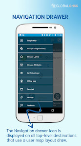
Top amazing features of GIS Mapper app:
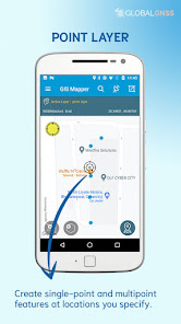
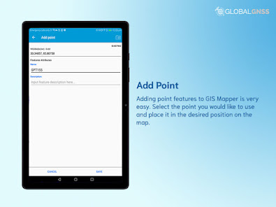
- GIS data collection to calculate the area and distance.
- Easier to import attributes from any other data format similar to our format .
- Multiple surveys with one set of attributes
- With multiple export options, a survey using images for any location is available.
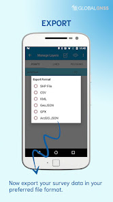
- Export GIS data file formats in CSV, KML, .SHP, GPX ,GeoJSON and ArcGIS JSON
- Direct export to Dropbox, Google Drive, FTP location.
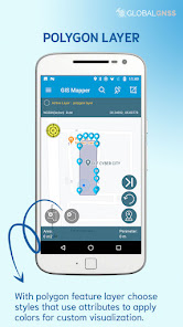
- Easier to import layers (point, line, and polygon) with CSV, KML or geojson file.
- The data can be featured on software like ArcGIS, qGIS etc.. after collection from GIS mapper.
- Connect to the external GNSS/GPS devices, NTRIP/RTK data can be utilised for high accuracy.
- Survey on online GIS maps, and offline maps (supports mbtiles)
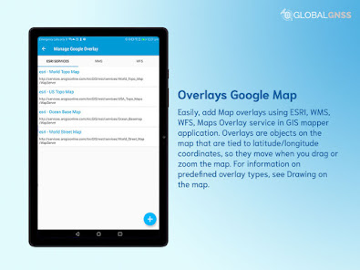
- WMS and WFS Surveyor tiled maps are supported, load topographic and orthophoto maps, geological surveys, cadastral information.
- Four methods of GIS data collection that are supported, (GPS / GNSS location, map cursor location, GIS Tracker, point projection using angle and distance).
- GIS Surveying on multiple types of GIS maps.
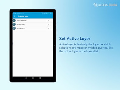
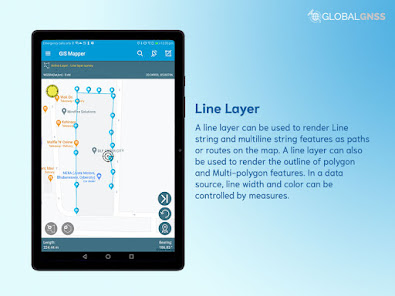
- Easier to viewable multiple layers including points, lines and polygons at the same time.
- Easier to group the data into many survey layers with a default set of attributes.
- Fabricate with line features or new polygon, and measure details like area, length and perimeter.
- Backup management.
- Works with the GEOID Model to provide elevation for a point.
- Receive Mock Location from 3rd party application.
- Coordinate System Geoid EGM96
The GIS Mapper application can be used by council, architects and builders to see factors such as ground level, contours, existing structures, adjoining structures, fences, and utility services.
GIS Mapper application is useful in various industries, such as:
- Forestry
- Residential Land, Commercial Land, and Government Land.
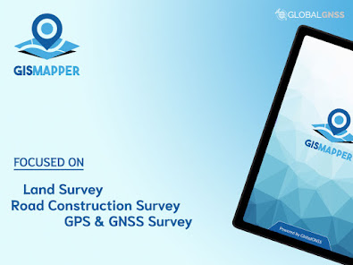
- GPS surveying and GNSS survey.
- Land Survey (Boundary survey, Construction survey, Subdivision survey, Topographic survey and Site planning survey)
- Agricultural and Farm Survey.
- Field Surveys.
- Environmental Systems.
- Highway Road surveys.
Supports Android OS 4.4 and above
This application is made ads-free and hence it will increase your productivity. If you have any problems in installing or downloading or if you face any kind of issue with the application functionalities kindly raise a ticket at: http://globalgnss.com/support/
GIS Mapper allows professional land surveyors with an opportunity to collect more accurate survey data in a stipulated time frame. Also, it is a technology-based application that can be used for various GIS mapping surveys such as field survey, land survey, and other surveys which includes field data collection including internal GPS or external GPS. The accuracy of the areas observations is also measured and use this data to create vectors, bearings, coordinates, elevations, areas, volumes, plans and maps.
GIS Mapper is a field and land survey application for geographical areas, analyze spatial information, edit the data and create maps, charts and reports that show users the results in visual forms.
Top amazing features of GIS Mapper app:
- GIS data collection to calculate the area and distance.
- Easier to import attributes from any other data format similar to our format .
- Multiple surveys with one set of attributes
- With multiple export options, a survey using images for any location is available.
- Export GIS data file formats in CSV, KML, .SHP, GPX ,GeoJSON and ArcGIS JSON
- Direct export to Dropbox, Google Drive, FTP location.
- Easier to import layers (point, line, and polygon) with CSV, KML or geojson file.
- The data can be featured on software like ArcGIS, qGIS etc.. after collection from GIS mapper.
- Connect to the external GNSS/GPS devices, NTRIP/RTK data can be utilised for high accuracy.
- Survey on online GIS maps, and offline maps (supports mbtiles)
- WMS and WFS Surveyor tiled maps are supported, load topographic and orthophoto maps, geological surveys, cadastral information.
- Four methods of GIS data collection that are supported, (GPS / GNSS location, map cursor location, GIS Tracker, point projection using angle and distance).
- GIS Surveying on multiple types of GIS maps.
- Easier to viewable multiple layers including points, lines and polygons at the same time.
- Easier to group the data into many survey layers with a default set of attributes.
- Fabricate with line features or new polygon, and measure details like area, length and perimeter.
- Backup management.
- Works with the GEOID Model to provide elevation for a point.
- Receive Mock Location from 3rd party application.
- Coordinate System Geoid EGM96
The GIS Mapper application can be used by council, architects and builders to see factors such as ground level, contours, existing structures, adjoining structures, fences, and utility services.
GIS Mapper application is useful in various industries, such as:
- Forestry
- Residential Land, Commercial Land, and Government Land.
- GPS surveying and GNSS survey.
- Land Survey (Boundary survey, Construction survey, Subdivision survey, Topographic survey and Site planning survey)
- Agricultural and Farm Survey.
- Field Surveys.
- Environmental Systems.
- Highway Road surveys.
Supports Android OS 4.4 and above
This application is made ads-free and hence it will increase your productivity. If you have any problems in installing or downloading or if you face any kind of issue with the application functionalities kindly raise a ticket at: http://globalgnss.com/support/
Updated on
Safety starts with understanding how developers collect and share your data. Data privacy and security practices may vary based on your use, region, and age. The developer provided this information and may update it over time.

No data shared with third parties
Learn more about how developers declare sharing

No data collected
Learn more about how developers declare collection

Data is encrypted in transit

You can request that data be deleted
Ratings and reviews
1.8
98 reviews

Mangetsu .Y
- Flag inappropriate
July 15, 2023
im gis user. if we compare to pc version this apps need more improvement. 1stly is hard to add your own data, browse button should important onscreen. 2nd data format is json, its good but not friendly to user. maybe can added 1@2 others format.. kml/shp file for user optional. 3rd how is the rulers use? 4th make them can be export to plan and export to pdf format.tqs..
6 people found this review helpful

Ricardo Hormaza
- Flag inappropriate
June 14, 2023
App asks for access to photos and media. I don't know why that's necessary. As an unknown app, trust needs to be built before asking for access to hundreds of personal files.
16 people found this review helpful

route Survey
- Flag inappropriate
August 8, 2023
Its totally fake, dont use this app, it doesn't work while you export your data after purchasing. It should be ban from Play Store.
7 people found this review helpful


