アメデス〜XRAIN(XバンドMPレーダ)〜
Contains ads
10K+
Downloads

Everyone
info
About this app
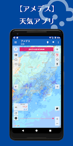
Amedesu is an app for viewing the rainfall data by the Ministry of Land, Infrastructure and Transport of XRAIN (X-Rain) (X band MP radar network).
Please to help us to disaster prevention activities by increasing torrential rain and localized heavy rain (guerrilla heavy rain) for flood and sediment disasters.
[Function of app]
• 1 minute update of radar image you can see
· Rain clouds play a continuous image of the image
(※ It may take some time to read by the communication environment)
· Past two weeks rain cloud data retrieval
[Target area]
Sapporo around
And Tohoku
·Kanto
Hokuriku
And Central
·Kinki
·China
Shikoku
·Kyushu
·Okinawa
(There does not appear some area)
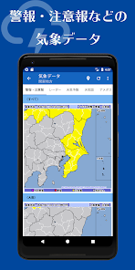
[Weather image]
And alarm / warning
Radar image (precipitation, lightning, tornadoes occur accuracy)
, Weather forecast and temperature
· Weather map
· AMeDAS (temperature, precipitation, wind speed and direction, sunshine duration, snow depth)
Regional "national, Hokkaido (North West, East and South), Tohoku (north-south), Kanto, Koshin, Hokuriku (East and West), Tokai, Kinki, Chugoku, Shikoku, Kyushu (North and South), Amami, Okinawa, Daito Island, Miyako, Yaeyama "
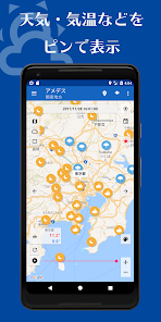
[View the weather information in the pin]
- weather, air temperature, air pressure, rainfall, display the humidity, the wind direction on the map
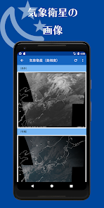
[Meteorological satellite (sunflower)]
· Infrared (black-and-white color)
Visible (black-and-white color)
Water vapor (black-and-white color)
- cloud top enhancement (※ high-frequency only)
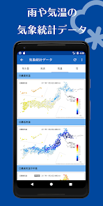
[Weather statistics image]
· Precipitation (1,3,24,48,72 hours)
- wind speed (maximum wind speed, the maximum instantaneous wind speed)
And temperature (maximum, minimum temperature, compared to the previous year, the day before ratio)
※ We use the weather image of the Japan Meteorological Agency announced
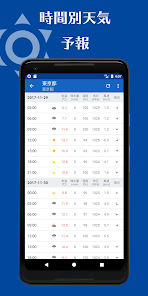
【weather forecast】
Today, three-day forecast
[Weekly weather forecast]
10 days forecast
[Risk distribution]
And sediment disaster warning, heavy rain flooding (flood damage), flood warning
[And XRAIN]
Weather observation network in accordance with state-of-the-art radar "X-band MP radar" that development is being promoted by the Ministry of Land, Infrastructure and Transport.
5 times more often than in the conventional radar, can be observed at 16 times the resolution possible substantially distributed in real time.
For even higher estimation accuracy of rainfall, and is expected to play early detection and monitoring of localized heavy rain (guerrilla rainstorm).
Please to help us to disaster prevention activities by increasing torrential rain and localized heavy rain (guerrilla heavy rain) for flood and sediment disasters.
[Function of app]
• 1 minute update of radar image you can see
· Rain clouds play a continuous image of the image
(※ It may take some time to read by the communication environment)
· Past two weeks rain cloud data retrieval
[Target area]
Sapporo around
And Tohoku
·Kanto
Hokuriku
And Central
·Kinki
·China
Shikoku
·Kyushu
·Okinawa
(There does not appear some area)
[Weather image]
And alarm / warning
Radar image (precipitation, lightning, tornadoes occur accuracy)
, Weather forecast and temperature
· Weather map
· AMeDAS (temperature, precipitation, wind speed and direction, sunshine duration, snow depth)
Regional "national, Hokkaido (North West, East and South), Tohoku (north-south), Kanto, Koshin, Hokuriku (East and West), Tokai, Kinki, Chugoku, Shikoku, Kyushu (North and South), Amami, Okinawa, Daito Island, Miyako, Yaeyama "
[View the weather information in the pin]
- weather, air temperature, air pressure, rainfall, display the humidity, the wind direction on the map
[Meteorological satellite (sunflower)]
· Infrared (black-and-white color)
Visible (black-and-white color)
Water vapor (black-and-white color)
- cloud top enhancement (※ high-frequency only)
[Weather statistics image]
· Precipitation (1,3,24,48,72 hours)
- wind speed (maximum wind speed, the maximum instantaneous wind speed)
And temperature (maximum, minimum temperature, compared to the previous year, the day before ratio)
※ We use the weather image of the Japan Meteorological Agency announced
【weather forecast】
Today, three-day forecast
[Weekly weather forecast]
10 days forecast
[Risk distribution]
And sediment disaster warning, heavy rain flooding (flood damage), flood warning
[And XRAIN]
Weather observation network in accordance with state-of-the-art radar "X-band MP radar" that development is being promoted by the Ministry of Land, Infrastructure and Transport.
5 times more often than in the conventional radar, can be observed at 16 times the resolution possible substantially distributed in real time.
For even higher estimation accuracy of rainfall, and is expected to play early detection and monitoring of localized heavy rain (guerrilla rainstorm).
Updated on
Safety starts with understanding how developers collect and share your data. Data privacy and security practices may vary based on your use, region, and age. The developer provided this information and may update it over time.

No data shared with third parties
Learn more about how developers declare sharing

This app may collect these data types
Location, App activity and 2 others

Data is encrypted in transit

Data can’t be deleted
What's new
・マップスタイルの変更(標準、シルバー、レトロ、ダーク、ナイト、暗紫色)
・気象統計データの不具合を修正
・天気図の不具合を修正
・黄砂情報を追加
・その他不具合の修正
・気象統計データの不具合を修正
・天気図の不具合を修正
・黄砂情報を追加
・その他不具合の修正