
Groomer Tracking Systems - GTS
3.2star
28 reviews
10K+
Downloads

Everyone
info

About this app
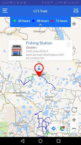
GTS Trails by Groomer Tracking Systems is a cutting edge app designed to offer the best
trail information for Snowmobilers. With a base map encompassing many of the existing
marked snowmobile trails, GTS Trails takes real time data from snow trail groomers to display when the trail was last groomed indicating where to likely find the smoothest
trails. Along with data on trail grooming maintenance, GTS Trails also updates trail
routing using GPS technology to provide the most up to date and accurate trail maps for
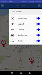
snowmobilers. GTS Trails maps also provides trail sponsor waypoint data including
restaurants and bars, fuel, lodging and parts/maintenance locations. GTS Trails by
Groomer Tracking Systems initially focuses on the Wisconsin trail system with plans to
expand to other regions.
trail information for Snowmobilers. With a base map encompassing many of the existing
marked snowmobile trails, GTS Trails takes real time data from snow trail groomers to display when the trail was last groomed indicating where to likely find the smoothest
trails. Along with data on trail grooming maintenance, GTS Trails also updates trail
routing using GPS technology to provide the most up to date and accurate trail maps for
snowmobilers. GTS Trails maps also provides trail sponsor waypoint data including
restaurants and bars, fuel, lodging and parts/maintenance locations. GTS Trails by
Groomer Tracking Systems initially focuses on the Wisconsin trail system with plans to
expand to other regions.
Updated on
Data safety
Developers can show information here about how their app collects and uses your data. Learn more about data safety

No information available
Ratings and reviews
3.2
28 reviews

Kellie B
- Flag inappropriate
December 26, 2021
Slow to find the trails. You have to zoom in close before the colored trails show up. Makes it hard to plan more than a short trip. Also, every time you use the app you need to disable the map markers in the settings or your map is peppered with location pins. I'll turn them on when I need them.
4 people found this review helpful

Del D-Main
- Flag inappropriate
- Show review history
February 24, 2023
This used to be a great app but now even with High bandwidth Wi-Fi, map loads fast but trail grooming overlay is extremely slow or fails to load in multiple areas of West Central Wisconsin (sometimes fails in certain areas completely even though groomers are out i.e. Chippewa County 2/24)

A Google user
- Flag inappropriate
January 29, 2020
I have found this works pretty good. You have to use some common sense: Know the trail system or be able to use a gps or a trail map to figure out where you are. It is a a good indication of which areas you should go to. I have found it to be pretty accurate more so that some of the trail conditions posting.
6 people found this review helpful
App support
phone
Phone number
+12628537256