
跟我去金門
Contains ads

Everyone
info
100+
Downloads

Everyone
Learn more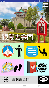

About this app
Development Statement
The "Follow Me to Kinmen" app is a privately developed app. It is not affiliated with, nor represents, Kinmen National Park or the Kinmen County Government. For more information, see the "About" section of the app. It is free to download and use, allowing users to more conveniently experience Kinmen tourism.
Introduction
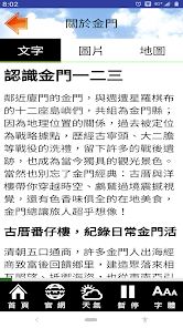
Kinmen Island and its twelve surrounding islands form Kinmen County. Due to its geographical location, it was once a strategic stronghold. It experienced battles such as Guningtou and Daerdan, leaving behind numerous post-war relics that have become unique tourist attractions today. Of course, don't forget Kinmen's classic offerings: historic houses and Western-style buildings that take you back in time, stunning cormorant sights, and delicious local cuisine. Kinmen never fails to delight travelers! (Source: Kinmen Tourism Website)
Functional Overview
--Text Navigation and Operation
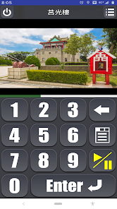
--Photo Album-style Browsing
--Text Captions for Photos
--Audio Navigation
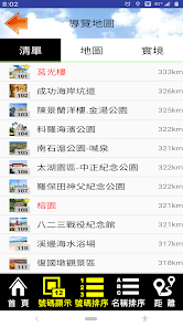
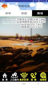
--Attraction List and VR Guide (Location VR)
--Attractions Sorted by Name and Distance
--Users Can Mark Key Points
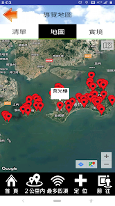
--Google Maps Integration for Location and Navigation
--Map Marking (e.g., Restrooms, Parking Lots, etc.)
--Switchable Map Mode between Standard and Satellite
--720° Real-Time Browsing
--Practical Digital Audio Guide
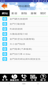
--Categorized Links to Related Blogs, Websites, and Videos
--Overall Interface Font Size Settings
--Font Size Adjustment for Text Browsing (Corresponds to Overall Font Settings)
--Setting the Appropriate Interface Language Based on the User's Phone Language Settings
--Added Function Keys for Frequently Used URLs
Permissions
--Background Location Permission: This app accesses your current location only for the purpose of providing navigational information about nearby locations, displaying your current location relative to attractions on a map, providing navigation, and supporting real-time distance guidance. This access continues even when the app is closed or not in use. This location information is not transmitted or used for other functions.
--Photo Permission: This app downloads photos and data for offline use, reducing cloud usage and enabling smoother navigation by accessing data from your phone.
--Camera Permission: This app provides AR location tracking for viewing attractions through the camera.
The "Follow Me to Kinmen" app is a privately developed app. It is not affiliated with, nor represents, Kinmen National Park or the Kinmen County Government. For more information, see the "About" section of the app. It is free to download and use, allowing users to more conveniently experience Kinmen tourism.
Introduction
Kinmen Island and its twelve surrounding islands form Kinmen County. Due to its geographical location, it was once a strategic stronghold. It experienced battles such as Guningtou and Daerdan, leaving behind numerous post-war relics that have become unique tourist attractions today. Of course, don't forget Kinmen's classic offerings: historic houses and Western-style buildings that take you back in time, stunning cormorant sights, and delicious local cuisine. Kinmen never fails to delight travelers! (Source: Kinmen Tourism Website)
Functional Overview
--Text Navigation and Operation
--Photo Album-style Browsing
--Text Captions for Photos
--Audio Navigation
--Attraction List and VR Guide (Location VR)
--Attractions Sorted by Name and Distance
--Users Can Mark Key Points
--Google Maps Integration for Location and Navigation
--Map Marking (e.g., Restrooms, Parking Lots, etc.)
--Switchable Map Mode between Standard and Satellite
--720° Real-Time Browsing
--Practical Digital Audio Guide
--Categorized Links to Related Blogs, Websites, and Videos
--Overall Interface Font Size Settings
--Font Size Adjustment for Text Browsing (Corresponds to Overall Font Settings)
--Setting the Appropriate Interface Language Based on the User's Phone Language Settings
--Added Function Keys for Frequently Used URLs
Permissions
--Background Location Permission: This app accesses your current location only for the purpose of providing navigational information about nearby locations, displaying your current location relative to attractions on a map, providing navigation, and supporting real-time distance guidance. This access continues even when the app is closed or not in use. This location information is not transmitted or used for other functions.
--Photo Permission: This app downloads photos and data for offline use, reducing cloud usage and enabling smoother navigation by accessing data from your phone.
--Camera Permission: This app provides AR location tracking for viewing attractions through the camera.
Updated on
Safety starts with understanding how developers collect and share your data. Data privacy and security practices may vary based on your use, region, and age. The developer provided this information and may update it over time.

No data shared with third parties
Learn more about how developers declare sharing

No data collected
Learn more about how developers declare collection

Data isn’t encrypted

You can request that data be deleted
What’s new
73 (2025/09/16) 支援 Android 15(API 35)
-- 聲明本App為民間自行開發,與政府無關連亦未代表該機關
-- 以上聲明顯示於 App啟動訊息、App內「使用說明」與「關於」、及 Play商店資訊
-- 移除所有原僅供參考之政府網站連結,以符合政策規範
-- 提供地圖參考點(Spot),包括旅遊中心,交通等點
-- 修正外部連結錯誤的問題
70 (2024.10.31) 支援 Android 14(API 34)
-- 修正地圖預設為衛星模式
-- 改進全景顯示功能
-- 新增地圖標示輔助功能(如洗手間,停車場)
-- 新增預設字體大小功能
-- 不定期資料改進與勘誤
61 (2023.11.08) 支援 Android 12、13(API 33)
-- 預設地圖模式更改為衛星模式
-- 清單排序方式改為按編號、按標記、按距離
-- 更正名稱排序點選錯誤
-- 修正解安裝時的問題
-- 修復小部分錯誤
-- 增修部分景點內容
60 (2022.03.10) 初版 支援正體中文
Everyone
Learn moreApp support
About the developer
黃建文
jenwenhuang.app@gmail.com
雨聲街42巷8號
4F
士林區
台北市, Taiwan 111


