GPSで走行データの記録&比較分析 - ArchivePro

10+
Downloads

Everyone
info
About this app
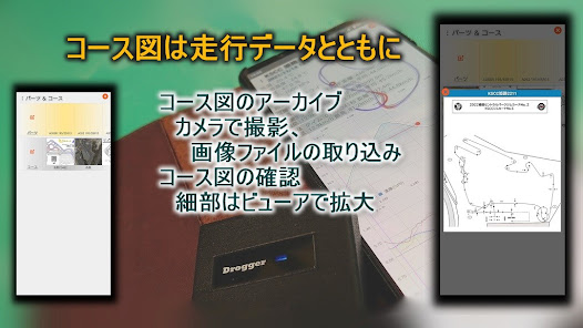
Record and analyze GPS position information, driving data such as speed, acceleration, roll, pitch, weather information (temperature, humidity, road surface temperature, weather, road surface conditions, atmospheric pressure), and vehicle setting information for motor sports. It's an app. Usage is here . It is a version localized for Japan so that it can be used without adding new functions and advertisements to the GPS driving record application (Archive). The recorded data can be checked with a viewer along with information such as speed, acceleration, pitch and roll. For temperature, humidity, and weather, weather information can be obtained and automatically set using the Internet (OpenWeatherMAP API key acquisition required). Temperature and humidity can be automatically set in cooperation with the SwitchBot thermohygrometer (MAC address of the SwitchBot thermohygrometer is required). You can also edit directly by tapping temperature, humidity, road surface temperature, weather, road surface conditions, and atmospheric pressure. By connecting a GPS logger other than the built-in GPS sensor, you can record a more accurate running track than the built-in GPS sensor. You can select the course to run from the course selection screen by tapping the course (course name) (course registration is required in advance). For course registration, you can shoot and record the course map using the course name and the built-in camera (you can check the recorded image with the viewer). To register setting information, select the part (part name) for which you want to register setting information from the parts selection screen by tapping . Setting information (adjustment values, memos) can be registered and changed by tapping the part (part name) selected as setting information (parts for which setting information is to be registered must be registered in advance). To register, modify, or delete courses and parts, select "Parts & Courses" from the menu. By tapping and on the Parts & Courses screen, you can register a new part or course. When registering a new part, you can enter the part name, memo, and number of uses on the input screen. When registering a new course, you can register the course name on the input screen. To modify parts, tap the part (part name) you want to modify. To shoot a course, tap the course (course name) you want to shoot and select "Shoot with camera" from the menu. To check the captured course (viewer), select "Display image" from the menu. To change the course name, select "Change course name" from the menu. Driving data and setting information can be deleted with a left swipe. To delete courses and parts, swipe up on the parts & course screen.
①Tap course, temperature), road temperature, road surface condition, humidity, atmospheric pressure, and weather to enter or select
*When linked with OpenWeatherMAP or SwitchBot Thermo-Hygrometer, it will be set automatically, so you only need to enter or change the part to be changed.
② Tap the standard setting (record the current smartphone installation status, OK only at the time of installation)
③ When connecting a GPS logger, select "Start pseudo location app" from the menu (start pseudo location app)
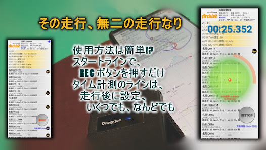
④ Start measurement by tapping REC
⑤ End the measurement by tapping STOP
⑥Tap the driving data to display the driving data
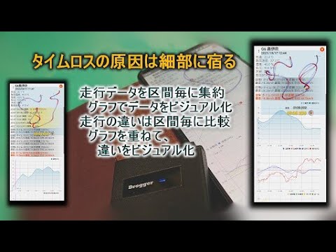
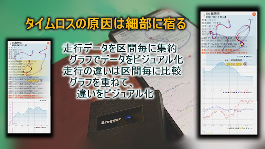
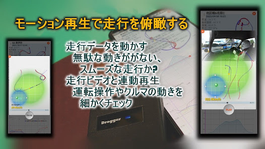
The confirmation screen displays graphs of temperature, humidity, road surface temperature, weather, road surface conditions, air pressure, setting information, driving trajectory, speed, acceleration, pitch and roll during driving. Various graphs can be traced by pinch operation
⑦ System settings (optional)
ACTION (Specify the service name when using a pseudo location service (DroggerGpsService for GPS sensor DG-PRO1))
ALPHA (Specify the low-pass filter during measurement in the range of 0.1 to 0.9)
API_ID (API key for OpenWeatherMAP)
AUTOSTOP (specifies the speed at which the measurement automatic stop function is enabled)
DEVICE_MAC (MAC address of SwitchBot Thermo-Hygrometer)
G-SCALE (Specify the scale of acceleration (G) in the range of 1 to 10)
HORIZONTAL (false if body is used vertically, true if used horizontally)
LATITUDE (Specify GPS latitude as 1 for north latitude and -1 for south latitude)
LPF (Specify the low-pass filter for graph display in the range of 0.1 to 0.9)
LOCUS (Specify the size of the running locus in the range of 200 to 400)
LONGITUDE (Set GPS longitude to 1 for west longitude and -1 for east longitude)
MEASURE_SWITCH (Specify the acceleration (G) at which measurement starts from 0.0 to 1.0)
MONITOR (Specify monitor display during motion playback, 0: not display, 1: acceleration, 2: pitch & roll, 3: phase)
NEARBY (Specify the allowable proximity distance between the measurement line and the travel path)
PACKAGE (Package name when using pseudo location service (jp.bizstation.drgps for GPS sensor DG-PRO1))
R-SCALE (Specify the size of the running path during motion playback in the range of 10 to 100)
SCALE (Specify the graph scale in the range of 0 to 10)
SPEED_CUT_FILTER (Specify the measurement start speed (km/s) in the range of 0.0 to 4.0)
TO_ADDRESS (email address to which the email is sent)
USE_STAND (true when using the main unit upright, false when using it lying down)
USE_LEFT (true if the left side faces down or to the left, false otherwise)
①Tap course, temperature), road temperature, road surface condition, humidity, atmospheric pressure, and weather to enter or select
*When linked with OpenWeatherMAP or SwitchBot Thermo-Hygrometer, it will be set automatically, so you only need to enter or change the part to be changed.
② Tap the standard setting (record the current smartphone installation status, OK only at the time of installation)
③ When connecting a GPS logger, select "Start pseudo location app" from the menu (start pseudo location app)
④ Start measurement by tapping REC
⑤ End the measurement by tapping STOP
⑥Tap the driving data to display the driving data
The confirmation screen displays graphs of temperature, humidity, road surface temperature, weather, road surface conditions, air pressure, setting information, driving trajectory, speed, acceleration, pitch and roll during driving. Various graphs can be traced by pinch operation
⑦ System settings (optional)
ACTION (Specify the service name when using a pseudo location service (DroggerGpsService for GPS sensor DG-PRO1))
ALPHA (Specify the low-pass filter during measurement in the range of 0.1 to 0.9)
API_ID (API key for OpenWeatherMAP)
AUTOSTOP (specifies the speed at which the measurement automatic stop function is enabled)
DEVICE_MAC (MAC address of SwitchBot Thermo-Hygrometer)
G-SCALE (Specify the scale of acceleration (G) in the range of 1 to 10)
HORIZONTAL (false if body is used vertically, true if used horizontally)
LATITUDE (Specify GPS latitude as 1 for north latitude and -1 for south latitude)
LPF (Specify the low-pass filter for graph display in the range of 0.1 to 0.9)
LOCUS (Specify the size of the running locus in the range of 200 to 400)
LONGITUDE (Set GPS longitude to 1 for west longitude and -1 for east longitude)
MEASURE_SWITCH (Specify the acceleration (G) at which measurement starts from 0.0 to 1.0)
MONITOR (Specify monitor display during motion playback, 0: not display, 1: acceleration, 2: pitch & roll, 3: phase)
NEARBY (Specify the allowable proximity distance between the measurement line and the travel path)
PACKAGE (Package name when using pseudo location service (jp.bizstation.drgps for GPS sensor DG-PRO1))
R-SCALE (Specify the size of the running path during motion playback in the range of 10 to 100)
SCALE (Specify the graph scale in the range of 0 to 10)
SPEED_CUT_FILTER (Specify the measurement start speed (km/s) in the range of 0.0 to 4.0)
TO_ADDRESS (email address to which the email is sent)
USE_STAND (true when using the main unit upright, false when using it lying down)
USE_LEFT (true if the left side faces down or to the left, false otherwise)
Updated on
Safety starts with understanding how developers collect and share your data. Data privacy and security practices may vary based on your use, region, and age. The developer provided this information and may update it over time.

This app may share these data types with third parties
Location and Photos and videos

No data collected
Learn more about how developers declare collection

Data is encrypted in transit

Data can’t be deleted
What's new
到着地点が計測ライン上にあるか判定を追加しました


