
GPS AutoLapTimer Laps
Contains adsIn-app purchases

100+
Downloads

Everyone
info
About this app
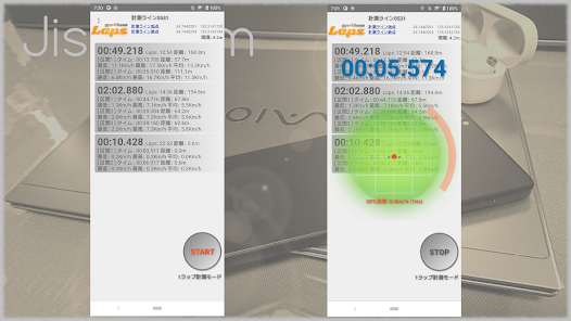
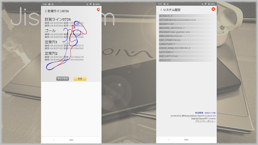
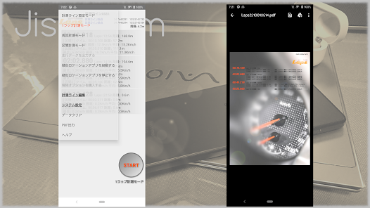
It is an application that records the time from pressing the start button to starting movement (detected by the accelerometer) until it passes the checker. The usage is here .. To set the checker, draw a line on the radar display and set the current position (latitude, longitude) by clicking CheckerStartPoint, CheckerEndPoint (direct input is also possible). After setting the checker, change the mode to OneLap mode, Circle mode or Split mode, and click the START button to enter the measurement standby state (STOP button display). It starts when motion is detected in the measurement standby state. OneLap mode ends the measurement once it passes the checker. Circle mode measures the passage of the checker multiple times.Split mode measures the interval using multiple checkers set in the checker file. Click the STOP button to end the measurement. To delete the measurement data, swipe left to delete the measurement data. Click on the checker screen to change the name, or swipe left delete it). By using the GPS receiver as a pseudo location service in addition to the built-in GPS sensor, it is possible to measure with higher accuracy than the built-in GPS sensor (DG-PRO1 is recommended).
①Click the measurement mode to select
Checker setting mode (when setting the checker)
OneLap mode (measurement that passes through the checker once)
Circle mode(Multiple measurement lines passing through)
Split mode (measures the passage of multiple checkers)
②Click START to measure or start setting
③Click STOP to measure or complete the setting
④System settings (optional)
Select System Settings from the menu
ACTION (Specify the service name when using the mock location service)
ALPHA (Specify the noise cut of the sensor in the range of 0.1 (weak) to 0.9 (strong))
HORIZONTAL (false if the main unit is installed vertically, true if it is horizontal)
LATITUDE (GPS latitude 1 is specified for both north and south latitudes)
LOCUS_DRAW_FILTER (Specify the speed at which radar drawing is stopped)
LONGITUDE (GPS longitude is specified as 1 for both west longitude and east longitude)
MEASURE_SWITCH (Specify the acceleration at the start of measurement (G))
NEARBY (Specify the allowable close distance between the checker and the travel locus)
PACKAGE (Specify the package name when using the mock location service)
SCALE (Specify the radar range from 5 to 100)
USE_LEFT (true if the left side is facing down or to the left, false otherwise)
USE_STAND (true when using the main unit upright, false when using it laid down)
Updated on
Safety starts with understanding how developers collect and share your data. Data privacy and security practices may vary based on your use, region, and age. The developer provided this information and may update it over time.

This app may share these data types with third parties
Location and Device or other IDs

No data collected
Learn more about how developers declare collection

Data is encrypted in transit

Data can’t be deleted
What's new
・The bottom speed is no longer displayed after passing the final measurement line.
・It is now possible to adjust the deceleration scale on the display of driving data.
・It is now possible to adjust the deceleration scale on the display of driving data.


