
NaAVIC
5K+
Downloads

Everyone
info


About this app
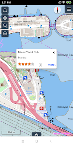
NaAVIC is a free Electronic Chart System in your pocket that will make marine navigation easy, safe, reliable, and fun.
This free app is for recreational boaters who want to navigate the surrounding waters safely while exploring new and interesting locations to fish, dive, eat etc. The app offers a range of features to make marine navigation easier and reliable that are delivered through a clear and intuitive interface designed specifically for mobile devices and tablets.
By utilizing a cloud-based approach with data streaming, the NaAVIC ECS enables all members of an expedition to more actively engage in the voyage as well as to share that voyage with fellow ‘marine friends’, hence building a community of like-minded users.
Features:
- Supports IHO S-57 charts and S-52 presentation
- Comprehensive route creation and navigation
- Offline navigation
- Displays boat position, speed, and course
- Notifications and alarms
- Find recreational hotspots
- Measure distances
- Stream additional data layers over the base map
- Point of Interest
Updated on
Safety starts with understanding how developers collect and share your data. Data privacy and security practices may vary based on your use, region, and age. The developer provided this information and may update it over time.

No data shared with third parties
Learn more about how developers declare sharing

No data collected
Learn more about how developers declare collection

Data isn’t encrypted

You can request that data be deleted
What's new
1) fixed geocode link
2) enhanced preview of tide data
2) enhanced preview of tide data