NOAA Buoy Reports & Data
In-app purchases
4.3star
142 reviews
10K+
Downloads

Everyone
info


About this app
This is the no-nonsense app to get you all the buoy information you need without the clutter of tide or weather forecasts.
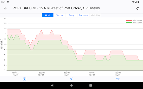
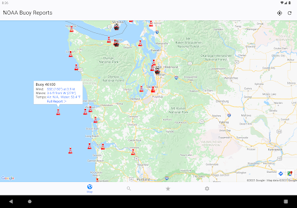
You can quickly find current buoy conditions with our intuitive map and past buoy data with our interactive graphs.
Data is available for over 1000 buoys and over 200 ships worldwide. Including both the Atlantic and Pacific oceans off of the United States and Canada, the Great Lakes, the Caribbean, and the waters around Ireland and Great Britain.
With NOAA Buoy Reports, you get:
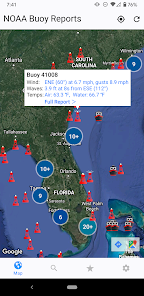
- Intuitive map interface
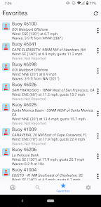
- Quick-view Favorites
- Locations of Tropical Storms, Hurricanes, and Cyclones per NHC
- Interactive Map Legend
- Full buoy current conditions (always free)
- Ship observations (free preview)
- Buoy Cams
- Past buoy data (up to 45 days ago with Premium upgrade)
- Interactive graphs
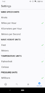
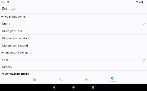
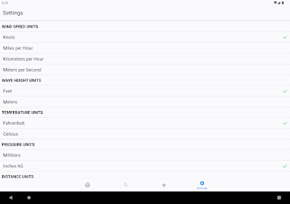
- Units in Metric or English
- Readings in local time
- Share data via Facebook, Twitter, Email, iMessage, etc.
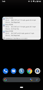
- Home Screen widget to monitor your favorites
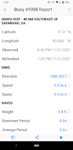
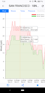
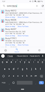
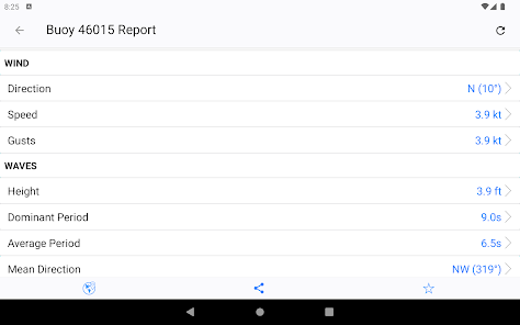
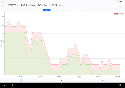
With our intuitive map interface, just tap on any buoy to get its latest reported conditions. A second tap will give you a complete summary of current conditions, or a graph of wind, wave, temperature, or pressure information so you can not only see what it's doing now, but what it was doing this morning, or even last week.
You can also add "Favorites" to quickly see what you are important to you with just a glance, and even monitor your favorites with the included Today widget.
This app DOES NOT provide tide data, or maritime or other weather forecasts. There are dedicated apps for these from other publishers that do an excellent job. This app specializes exclusively on buoy and ship observation data.
Please note that not all buoys have all types of data available, and buoy's do experience intermittent outages - a life at sea can be harsh!
Raw source data compliments of NOAA, National Data Buoy Center (NDBC), and the National Hurricane Center (NHC).
Juggernaut Technology, Inc. is not associated with NOAA, NDBC, NHC, or any other government organization. Juggernaut Technology, Inc. is not liable for any errors or omissions in the Information and shall not be liable for any loss, injury or damage of any kind caused by its use.
You can quickly find current buoy conditions with our intuitive map and past buoy data with our interactive graphs.
Data is available for over 1000 buoys and over 200 ships worldwide. Including both the Atlantic and Pacific oceans off of the United States and Canada, the Great Lakes, the Caribbean, and the waters around Ireland and Great Britain.
With NOAA Buoy Reports, you get:
- Intuitive map interface
- Quick-view Favorites
- Locations of Tropical Storms, Hurricanes, and Cyclones per NHC
- Interactive Map Legend
- Full buoy current conditions (always free)
- Ship observations (free preview)
- Buoy Cams
- Past buoy data (up to 45 days ago with Premium upgrade)
- Interactive graphs
- Units in Metric or English
- Readings in local time
- Share data via Facebook, Twitter, Email, iMessage, etc.
- Home Screen widget to monitor your favorites
With our intuitive map interface, just tap on any buoy to get its latest reported conditions. A second tap will give you a complete summary of current conditions, or a graph of wind, wave, temperature, or pressure information so you can not only see what it's doing now, but what it was doing this morning, or even last week.
You can also add "Favorites" to quickly see what you are important to you with just a glance, and even monitor your favorites with the included Today widget.
This app DOES NOT provide tide data, or maritime or other weather forecasts. There are dedicated apps for these from other publishers that do an excellent job. This app specializes exclusively on buoy and ship observation data.
Please note that not all buoys have all types of data available, and buoy's do experience intermittent outages - a life at sea can be harsh!
Raw source data compliments of NOAA, National Data Buoy Center (NDBC), and the National Hurricane Center (NHC).
Juggernaut Technology, Inc. is not associated with NOAA, NDBC, NHC, or any other government organization. Juggernaut Technology, Inc. is not liable for any errors or omissions in the Information and shall not be liable for any loss, injury or damage of any kind caused by its use.
Updated on
Safety starts with understanding how developers collect and share your data. Data privacy and security practices may vary based on your use, region, and age. The developer provided this information and may update it over time.


Ratings and reviews
4.3
138 reviews

Retired & Love It
- Flag inappropriate
May 18, 2024
Other than location, some buoys provide very little information.
3 people found this review helpful
Juggernaut Technology, Inc.
May 18, 2024
The instrumentation installed to record Wave, Wind, Temperatures, Pressure, Visibility, etc. vary by buoy, If the buoy does not have the instrumentation to record the data type, the app can't report it. The app is free to try to see if buoys at locations you care about report the data you want.

Hans Solo
- Flag inappropriate
June 22, 2024
Just shows current conditions a few day Forcast would be nice
2 people found this review helpful

Jeff Nichols
- Flag inappropriate
June 26, 2024
Can't read particulars. Last site was much better layout
What's new
+ More Buoys!
+ Performance, User Interface, and Stability improvements.
If you have any questions, problems, or comments, please email us at help@NOAABuoyReports.com!
+ Performance, User Interface, and Stability improvements.
If you have any questions, problems, or comments, please email us at help@NOAABuoyReports.com!


