

১ হাজাৰ+
ডাউনল’ড

সকলো
info

এই এপ্টোৰ বিষয়ে
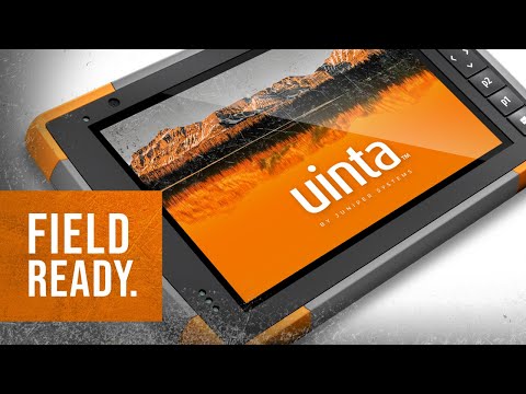
Uinta is a customizable and hassle-free mapping and data collection software. Tired of complex and expensive GIS mapping software with limited abilities to customize for your job? We were too. Train new users in minutes with Uinta.
Top Features
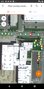
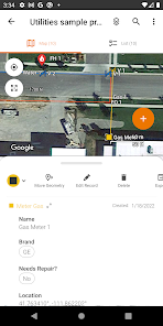
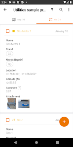
• Efficient Data Capture - Replace paper forms with efficient electronic data entry forms, for use with or without maps
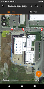
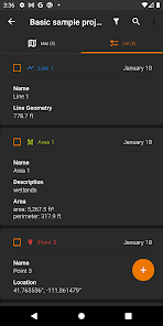
• Professional Mapping - Quickly map points, lines, and areas. High-accuracy mapping supported
• Customizable - Create custom project templates so field-collected data reflects your job(s)
• User-friendly - Simple interface allows users to be trained and collecting data in minutes
• Sharable - Export data to a file, print professional PDF map reports, and create optional cloud projects
• Free & Live Support - Get a jump start on your project with help from Juniper Systems' in-house customer success team
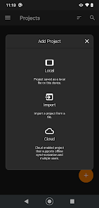
Project templates in Uinta can easily be created to meet data collection needs across various industries and job types. From utility mapping, asset management, or irrigation to more niche applications such as utility pole mapping, Uinta can be tailored to meet your needs.
Top Features
• Efficient Data Capture - Replace paper forms with efficient electronic data entry forms, for use with or without maps
• Professional Mapping - Quickly map points, lines, and areas. High-accuracy mapping supported
• Customizable - Create custom project templates so field-collected data reflects your job(s)
• User-friendly - Simple interface allows users to be trained and collecting data in minutes
• Sharable - Export data to a file, print professional PDF map reports, and create optional cloud projects
• Free & Live Support - Get a jump start on your project with help from Juniper Systems' in-house customer success team
Project templates in Uinta can easily be created to meet data collection needs across various industries and job types. From utility mapping, asset management, or irrigation to more niche applications such as utility pole mapping, Uinta can be tailored to meet your needs.
আপডে’ট কৰা তাৰিখ
বিকাশকৰ্তাসকলে আপোনাৰ ডেটা কেনেকৈ সংগ্ৰহ আৰু শ্বেয়াৰ কৰে সেয়া বুজি পোৱাৰ জৰিয়তে সুৰক্ষা আৰম্ভ হয়। ডেটাৰ গোপনীয়তা আৰু সুৰক্ষা প্ৰণালী আপোনাৰ ব্যৱহাৰ, অঞ্চল আৰু বয়সৰ ওপৰত ভিত্তি কৰি ভিন্ন হ’ব পাৰে। বিকাশকৰ্তাগৰাকীয়ে এই তথ্যখিনি প্ৰদান কৰিছে আৰু সময়ৰ লগে লগে এয়া আপডে’ট কৰিব পাৰে।

তৃতীয় পক্ষৰ সৈতে কোনো ডেটা শ্বেয়াৰ কৰা নাই
বিকাশকৰ্তাই ডেটা শ্বেয়াৰ কৰাৰ বিষয়ে কেনেকৈ ঘোষণা কৰে সেই বিষয়ে অধিক জানক

এই এপ্টোৱে এই ধৰণৰ ডেটা সংগ্ৰহ কৰিব পাৰে
অৱস্থান, ব্যক্তিগত তথ্য আৰু অন্য 4 টা

ডেটা ট্ৰেনজিটত এনক্ৰিপ্ট কৰা হয়

আপুনি ডেটা মচিবলৈ অনুৰোধ কৰিব পাৰে
নতুন কি আছে
-GeoPackage import/export
-Nested relational queries
-User application preferences
-Set displayed geometry limit on map
-Bug fixes
-Nested relational queries
-User application preferences
-Set displayed geometry limit on map
-Bug fixes
