Cape Verde Offline GPS Charts
5+
Preuzimanja

Svako
info
O aplikaciji
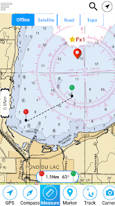
MapiTech launches on the market the best official up-to-date RNC (raster) combined with S57 nautical charts (digital): marinas, wrecks, fishing spots, boat ramps, POI.
This app displays seamlessly the beauty of paper charts, a "look and feel" experience combined with S57 data.
You will be impressed how appealing the raster charts look, how easily you pan and zoom and ..there's much more you will like about Mapitech App.
The interactive menu is very intuitive, the maps are downloaded to the device itself, it works in OFFLINE mode. No need of Internet connection.
Chart details and performances of a professional GPS chart plotter at a minimal cost.
At glance:
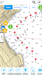
•It works without mobile coverage (OFFLINE)
•Powerful search
•Multiple overlays for different use (fishing, sailing or cruising)
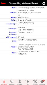
•ActiveCaptain community integration
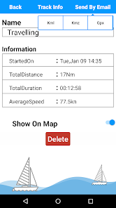
•KML KMZ GPX viewer and converter embedded in the app
•Very detailed and updated charts
•Waypoints
•Markers & Favorites
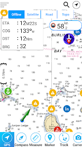
•Multiple tracks: Record your track, instant speed time, COG - course over ground
•Geo - tagged photo management
•Distance measure
•Compass
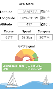
•GPS window with very detailed info
•User friendly on latest android
Join the Captain community of 100.000+ boaters who write review and provide updated hazard info. Must have for all boaters!
This app displays seamlessly the beauty of paper charts, a "look and feel" experience combined with S57 data.
You will be impressed how appealing the raster charts look, how easily you pan and zoom and ..there's much more you will like about Mapitech App.
The interactive menu is very intuitive, the maps are downloaded to the device itself, it works in OFFLINE mode. No need of Internet connection.
Chart details and performances of a professional GPS chart plotter at a minimal cost.
At glance:
•It works without mobile coverage (OFFLINE)
•Powerful search
•Multiple overlays for different use (fishing, sailing or cruising)
•ActiveCaptain community integration
•KML KMZ GPX viewer and converter embedded in the app
•Very detailed and updated charts
•Waypoints
•Markers & Favorites
•Multiple tracks: Record your track, instant speed time, COG - course over ground
•Geo - tagged photo management
•Distance measure
•Compass
•GPS window with very detailed info
•User friendly on latest android
Join the Captain community of 100.000+ boaters who write review and provide updated hazard info. Must have for all boaters!
Ažurirano dana
Sigurnost počinje razumijevanjem na koji način programeri prikupljaju i dijele vaše podatke. Privatnost podataka i sigurnosne prakse se mogu razlikovati ovisno o korištenju, regiji i dobi. Programer je pružio ove informacije i može ih s vremenom ažurirati.

Podaci se ne dijele s trećim stranama
Saznajte više o načinu na koji programeri pružaju izjavu o dijeljenju

Podaci se ne prikupljaju
Saznajte više o načinu na koji programeri pružaju izjavu o prikupljanju
Šta ima novo
Performance Improved


