

vSite AR

5K+
Downloads

Everyone
info


About this app
Construction Management for Subsurface Infrastructure
Real-time visibility into progress, quantities, and profitability.
vSite simplifies and de-risks underground utility work by making it easy to understand, document, and track projects in the field. On the back end, it delivers real-time insights—powered by AI, AR, and phone-based 3D capture—to keep quantities, costs, and updates accurate and current.
What teams can do with vSite:
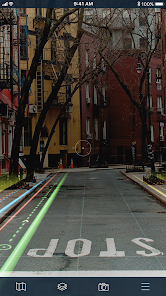
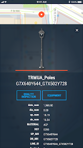
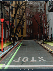
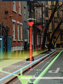
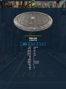
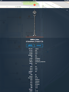
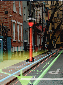
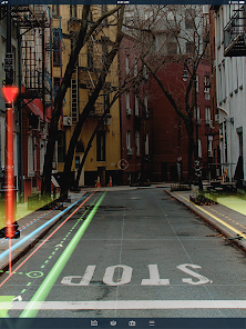
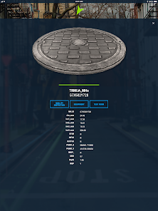
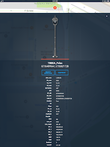
✅ Get instant answers in the field — open the latest drawings and utility data, visualize with AR, and capture 3D test pits/as-builts in minutes.
✅ Track production & costs automatically — reconcile utilization, quantities, and spend against estimates without spreadsheets.
✅ Stay on schedule with fewer errors — AI-powered QA/QC, tolerance checks, and alerts reduce rework and delays.
✅ Collaborate seamlessly — owners, engineers, locators, and contractors work from the same source of truth via web and mobile.
A single easy-to-use toolbox:
Stop juggling scanning apps, data collectors, BIM viewers, time sheets, and CSV exports. vSite unifies them into a single, intuitive platform that integrates with Autodesk Construction Cloud, Bentley iTwin, Esri ArcGIS, and other leading systems, simplifying your stack and boosting efficiency.
AI-Powered efficiency, AR-grade precision:
vSite’s AI automates manual documentation and performs real-time quality checks, while construction-grade AR guides field operations with trench-ready accuracy.
Used on hundreds of utility projects, vSite helps teams track progress, ensure quality, reduce line-strike risk, and prevent delays, so jobs finish on time and on budget.
Real-time visibility into progress, quantities, and profitability.
vSite simplifies and de-risks underground utility work by making it easy to understand, document, and track projects in the field. On the back end, it delivers real-time insights—powered by AI, AR, and phone-based 3D capture—to keep quantities, costs, and updates accurate and current.
What teams can do with vSite:
✅ Get instant answers in the field — open the latest drawings and utility data, visualize with AR, and capture 3D test pits/as-builts in minutes.
✅ Track production & costs automatically — reconcile utilization, quantities, and spend against estimates without spreadsheets.
✅ Stay on schedule with fewer errors — AI-powered QA/QC, tolerance checks, and alerts reduce rework and delays.
✅ Collaborate seamlessly — owners, engineers, locators, and contractors work from the same source of truth via web and mobile.
A single easy-to-use toolbox:
Stop juggling scanning apps, data collectors, BIM viewers, time sheets, and CSV exports. vSite unifies them into a single, intuitive platform that integrates with Autodesk Construction Cloud, Bentley iTwin, Esri ArcGIS, and other leading systems, simplifying your stack and boosting efficiency.
AI-Powered efficiency, AR-grade precision:
vSite’s AI automates manual documentation and performs real-time quality checks, while construction-grade AR guides field operations with trench-ready accuracy.
Used on hundreds of utility projects, vSite helps teams track progress, ensure quality, reduce line-strike risk, and prevent delays, so jobs finish on time and on budget.
Updated on
Safety starts with understanding how developers collect and share your data. Data privacy and security practices may vary based on your use, region, and age. The developer provided this information and may update it over time.

No data shared with third parties
Learn more about how developers declare sharing

This app may collect these data types
Location, Photos and videos and 4 others

Data is encrypted in transit

Data can’t be deleted
App support
About the developer
Vgis Inc.
info@vgis.io
238 Dunforest Ave
Toronto, ON M2N 4J9
Canada
+1 416-939-5449