
MA GPX: Create your GPS tracks
Kupovina unutar aplikacije

2,4star
136 recenzija
10 hilj.+
Preuzimanja

Svako
info


O aplikaciji
Better than a hiking GPS, MA GPX is the complete hiking application.
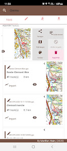
# Prepare your GPS tracks
You import your tracks from KML or GPX files and modify them as you want.
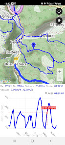
You draw the track, instantly obtain the distance and then the measurement of the elevation.
To create the track, you draw the track with your finger, you can stretch it, delete sections, cut it, add sections,...
Your tracks are stored in the tracks history. You can then resume each of the tracks.
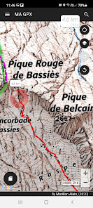
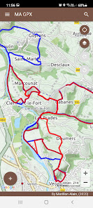
You display your tracks on the map, share them with your friends, or simply display profiles and statistics.
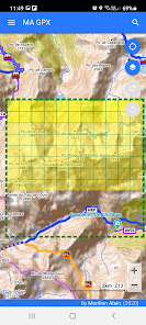
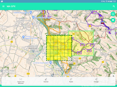
# Offline Maps (outdoor activities)
To be guaranteed to get the necessary maps of outdoor activities, you download maps by advance.
You download the maps from a predefined area on the map or simply from a track to follow.
The cache containing the downloaded maps can be viewed to obtain the size rate.
# Outdoors
Thanks to the quality screen of your smartphone MA GPX replaces any hiking GPS, as you can:
- see on the map your position at any time.
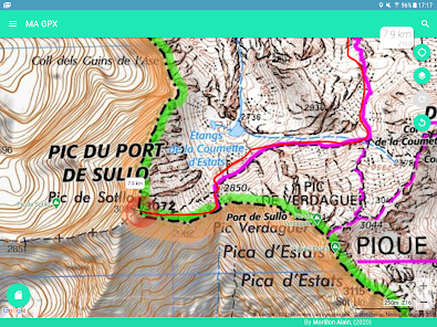
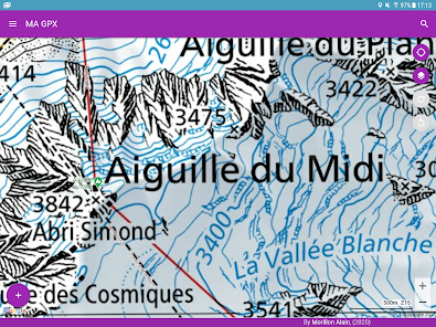
- display the tracks of your choice.
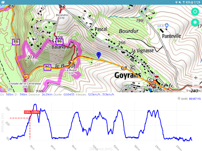
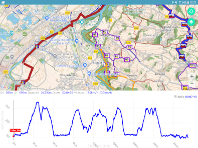
- display statistical data (altitudes, distances, breaks, speeds, percentage of slopes and instantaneous speed)
- save your road.
- save points of interest (POI) on your track.
- Make a sight line with the compass of your device to obtain the point in sight. The azimuth will be plotted on the map at the target point.
And from the voice guide, you are able to:
- to be guided by the sound assistance to follow a route.
- to listen to the directions and the deviations from the trajectory.
- to suspend or resume guidance at any time.
- to change the route to follow at any time.
# Maps
Many quality maps are available such as Swiss, France, Belgian, Spanish maps and many more.
You have access to specific layers (overlay maps) allowing
- to obtain the inclination of the terrain
- to obtain the OpenStreetMap paths
- to obtain the European paths of great hikes
# Other features
Useful feature are available such as:
- Share your position by SMS or email (In an emergency, for example).
- Save or restore all your tracks in a single operation.
- Obtain the geographic coordinates of a point and share it.
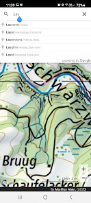
- Search a geographic position on the map from latitude and longitude or place name.
- View or edit the track(s) of your choice when the GPX file contains several tracks.
- Merge a track composed of several tracks.
- Add POI to track.
- Cut the track into several sections.
- Easily resume each modification from the "Undo/Redo" buttons.
# Conclusion
This application is ideal for preparing and carrying out many outdoor activities:
- Hiking,
- Running,
- Trail,
- Mountain biking,
- Skiing,
- Horseback riding,
- Racket,
- Hunt,
- Mushroom picking,
- ...
# Help / Support
Help is available in the main menu under "Help":
For problems encountered, improvements, contact: support@ma-logiciel.com
# Prepare your GPS tracks
You import your tracks from KML or GPX files and modify them as you want.
You draw the track, instantly obtain the distance and then the measurement of the elevation.
To create the track, you draw the track with your finger, you can stretch it, delete sections, cut it, add sections,...
Your tracks are stored in the tracks history. You can then resume each of the tracks.
You display your tracks on the map, share them with your friends, or simply display profiles and statistics.
# Offline Maps (outdoor activities)
To be guaranteed to get the necessary maps of outdoor activities, you download maps by advance.
You download the maps from a predefined area on the map or simply from a track to follow.
The cache containing the downloaded maps can be viewed to obtain the size rate.
# Outdoors
Thanks to the quality screen of your smartphone MA GPX replaces any hiking GPS, as you can:
- see on the map your position at any time.
- display the tracks of your choice.
- display statistical data (altitudes, distances, breaks, speeds, percentage of slopes and instantaneous speed)
- save your road.
- save points of interest (POI) on your track.
- Make a sight line with the compass of your device to obtain the point in sight. The azimuth will be plotted on the map at the target point.
And from the voice guide, you are able to:
- to be guided by the sound assistance to follow a route.
- to listen to the directions and the deviations from the trajectory.
- to suspend or resume guidance at any time.
- to change the route to follow at any time.
# Maps
Many quality maps are available such as Swiss, France, Belgian, Spanish maps and many more.
You have access to specific layers (overlay maps) allowing
- to obtain the inclination of the terrain
- to obtain the OpenStreetMap paths
- to obtain the European paths of great hikes
# Other features
Useful feature are available such as:
- Share your position by SMS or email (In an emergency, for example).
- Save or restore all your tracks in a single operation.
- Obtain the geographic coordinates of a point and share it.
- Search a geographic position on the map from latitude and longitude or place name.
- View or edit the track(s) of your choice when the GPX file contains several tracks.
- Merge a track composed of several tracks.
- Add POI to track.
- Cut the track into several sections.
- Easily resume each modification from the "Undo/Redo" buttons.
# Conclusion
This application is ideal for preparing and carrying out many outdoor activities:
- Hiking,
- Running,
- Trail,
- Mountain biking,
- Skiing,
- Horseback riding,
- Racket,
- Hunt,
- Mushroom picking,
- ...
# Help / Support
Help is available in the main menu under "Help":
For problems encountered, improvements, contact: support@ma-logiciel.com
Ažurirano dana
Sigurnost počinje razumijevanjem na koji način programeri prikupljaju i dijele vaše podatke. Privatnost podataka i sigurnosne prakse se mogu razlikovati ovisno o korištenju, regiji i dobi. Programer je pružio ove informacije i može ih s vremenom ažurirati.

Podaci se ne dijele s trećim stranama
Saznajte više o načinu na koji programeri pružaju izjavu o dijeljenju

Podaci se ne prikupljaju
Saznajte više o načinu na koji programeri pružaju izjavu o prikupljanju

Podaci su šifrirani u prijenosu
Ocjene i recenzije
2,4
126 recenzija
Šta ima novo
- Adding your own maps becomes possible. Just provide the uri of a tile server that you can find on the internet, example OSM, Thunderforest, ...
- Changes requested by Google
- Changes requested by Google