
MA GPX: Create your GPS tracks
In-app purchases

2.4star
136 reviews
10K+
Downloads

Everyone
info


About this app
Better than a hiking GPS, MA GPX is the complete hiking application.
# Prepare your GPS tracks
You import your tracks from KML or GPX files and modify them as you want.
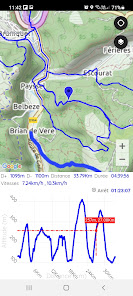
You draw the track, instantly obtain the distance and then the measurement of the elevation.
To create the track, you draw the track with your finger, you can stretch it, delete sections, cut it, add sections,...
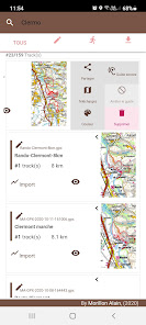
Your tracks are stored in the tracks history. You can then resume each of the tracks.
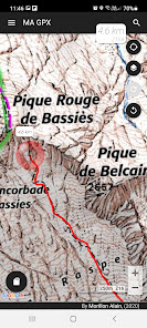
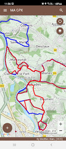
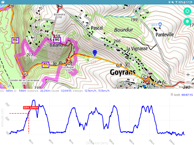
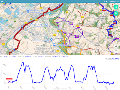
You display your tracks on the map, share them with your friends, or simply display profiles and statistics.
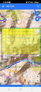
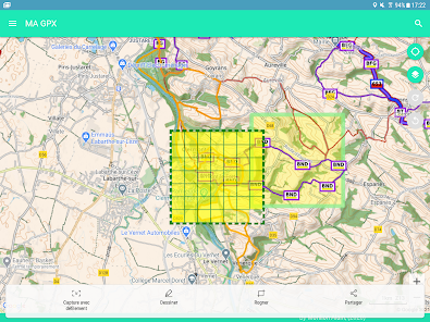
# Offline Maps (outdoor activities)
To be guaranteed to get the necessary maps of outdoor activities, you download maps by advance.
You download the maps from a predefined area on the map or simply from a track to follow.
The cache containing the downloaded maps can be viewed to obtain the size rate.
# Outdoors
Thanks to the quality screen of your smartphone MA GPX replaces any hiking GPS, as you can:
- see on the map your position at any time.
- display the tracks of your choice.
- display statistical data (altitudes, distances, breaks, speeds, percentage of slopes and instantaneous speed)
- save your road.
- save points of interest (POI) on your track.
- Make a sight line with the compass of your device to obtain the point in sight. The azimuth will be plotted on the map at the target point.
And from the voice guide, you are able to:
- to be guided by the sound assistance to follow a route.
- to listen to the directions and the deviations from the trajectory.
- to suspend or resume guidance at any time.
- to change the route to follow at any time.
# Maps
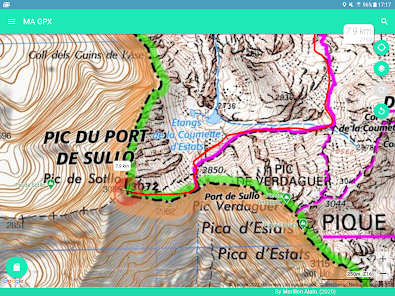
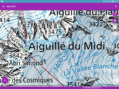
Many quality maps are available such as Swiss, France, Belgian, Spanish maps and many more.
You have access to specific layers (overlay maps) allowing
- to obtain the inclination of the terrain
- to obtain the OpenStreetMap paths
- to obtain the European paths of great hikes
# Other features
Useful feature are available such as:
- Share your position by SMS or email (In an emergency, for example).
- Save or restore all your tracks in a single operation.
- Obtain the geographic coordinates of a point and share it.
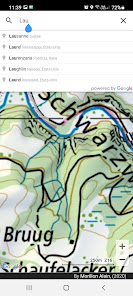
- Search a geographic position on the map from latitude and longitude or place name.
- View or edit the track(s) of your choice when the GPX file contains several tracks.
- Merge a track composed of several tracks.
- Add POI to track.
- Cut the track into several sections.
- Easily resume each modification from the "Undo/Redo" buttons.
# Conclusion
This application is ideal for preparing and carrying out many outdoor activities:
- Hiking,
- Running,
- Trail,
- Mountain biking,
- Skiing,
- Horseback riding,
- Racket,
- Hunt,
- Mushroom picking,
- ...
# Help / Support
Help is available in the main menu under "Help":
For problems encountered, improvements, contact: support@ma-logiciel.com
# Prepare your GPS tracks
You import your tracks from KML or GPX files and modify them as you want.
You draw the track, instantly obtain the distance and then the measurement of the elevation.
To create the track, you draw the track with your finger, you can stretch it, delete sections, cut it, add sections,...
Your tracks are stored in the tracks history. You can then resume each of the tracks.
You display your tracks on the map, share them with your friends, or simply display profiles and statistics.
# Offline Maps (outdoor activities)
To be guaranteed to get the necessary maps of outdoor activities, you download maps by advance.
You download the maps from a predefined area on the map or simply from a track to follow.
The cache containing the downloaded maps can be viewed to obtain the size rate.
# Outdoors
Thanks to the quality screen of your smartphone MA GPX replaces any hiking GPS, as you can:
- see on the map your position at any time.
- display the tracks of your choice.
- display statistical data (altitudes, distances, breaks, speeds, percentage of slopes and instantaneous speed)
- save your road.
- save points of interest (POI) on your track.
- Make a sight line with the compass of your device to obtain the point in sight. The azimuth will be plotted on the map at the target point.
And from the voice guide, you are able to:
- to be guided by the sound assistance to follow a route.
- to listen to the directions and the deviations from the trajectory.
- to suspend or resume guidance at any time.
- to change the route to follow at any time.
# Maps
Many quality maps are available such as Swiss, France, Belgian, Spanish maps and many more.
You have access to specific layers (overlay maps) allowing
- to obtain the inclination of the terrain
- to obtain the OpenStreetMap paths
- to obtain the European paths of great hikes
# Other features
Useful feature are available such as:
- Share your position by SMS or email (In an emergency, for example).
- Save or restore all your tracks in a single operation.
- Obtain the geographic coordinates of a point and share it.
- Search a geographic position on the map from latitude and longitude or place name.
- View or edit the track(s) of your choice when the GPX file contains several tracks.
- Merge a track composed of several tracks.
- Add POI to track.
- Cut the track into several sections.
- Easily resume each modification from the "Undo/Redo" buttons.
# Conclusion
This application is ideal for preparing and carrying out many outdoor activities:
- Hiking,
- Running,
- Trail,
- Mountain biking,
- Skiing,
- Horseback riding,
- Racket,
- Hunt,
- Mushroom picking,
- ...
# Help / Support
Help is available in the main menu under "Help":
For problems encountered, improvements, contact: support@ma-logiciel.com
Updated on
Safety starts with understanding how developers collect and share your data. Data privacy and security practices may vary based on your use, region, and age. The developer provided this information and may update it over time.

No data shared with third parties
Learn more about how developers declare sharing

No data collected
Learn more about how developers declare collection

Data is encrypted in transit
Ratings and reviews
2.4
126 reviews

The Silk Road
- Flag inappropriate
September 3, 2022
Not user friendly, things are just not where you expect them to be and it's difficult to make any sense out of it. Maps are as weird as they get... you choose "open Street maps" and it doesn't look like it, there are loads of lines that don't belong. Just a messed up app, not for me.
Cartes, Randonnées, GPS, GPX
September 16, 2023
Could you contact support@ma-logiciel.com in order to help you ? Have you take a look on video in Help menu ?? A response please? Please contact us in order to improve our app.

Nick
- Flag inappropriate
June 14, 2021
They don't tell you until *after* you've taken the time to draw out your entire ride that they require a subscription to save. Frustratingly deceptive.
9 people found this review helpful
Cartes, Randonnées, GPS, GPX
September 7, 2021
Have you seen a subscription menu? Could you contact support@ma-logiciel.com to let you a bit more time for evaluation of the app?

Dan Latimer
- Flag inappropriate
September 5, 2021
Don't tell you it's paid only if you want to use the track you edit. Scam app pretending to be free.
3 people found this review helpful
Cartes, Randonnées, GPS, GPX
March 5, 2024
I am very surprised of your feedback, where have you seen it was free?
Please contact support@ma-logiciel.com for more information.
Merci d'avance de ne pas dégrader la notation de l'application injustement
What's new
- Adding your own maps becomes possible. Just provide the uri of a tile server that you can find on the internet, example OSM, Thunderforest, ...
- Changes requested by Google
- Changes requested by Google