Vermont Snowmobile Trails
4,2star
72 avis
10K+
Téléchargements

Tout public
info


À propos de l'application
Vermont Association of Snow Travelers is pleased to provide our new, no reception needed, mobile version of our official Trails Map.
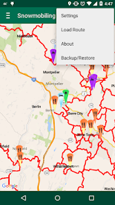
Our free app features our entire statewide trail network and junctions, along with parking locations and services accessible by trail. We make it easy to find where to eat, get gas, parts and repairs, or stay the night.
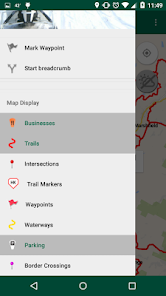
Tap a trail or junction pin for more information on junction or trail number as well as contact information for the club responsible for maintenance of each trail section. Tap a service pin to see its category; display the map legend if needed, found by tapping Preferences.
Going to an unfamiliar area? Enable GPS on your phone and never get lost! No need to try to figure out where you are, your phone app will show you relative to the trails, junctions and towns, with or without reception!
Don't miss out on all these features:
• app centers on your current location
• corridor, corridor 4, secondary and commerce trail coverage
• display current satellite GPS location
• display all trail data, parking and services without reception
• choice of street view or hybrid satellite view
• display the current radar, with reception
• GPS breadcrumb tracking, just tap the compass to start and stop
• mark and save favorite spots as waypoints
• import routes created in the vtvast.org web map
• cloud backup and restore of routes and waypoints
REMEMBER: Continued use of GPS running in the background can dramatically decrease battery life. Please be prepared.
Trail status and conditions can change at a moment’s notice so please use this tool to aid you in your travels but do not depend solely upon it.
To contact us with questions, please visit www.vtvast.org.
Disclaimer: V.A.S.T. and Mohawk Valley GIS (app developers) cannot guarantee the accuracy of the trail locations nor can V.A.S.T. and Mohawk Valley assume responsibility for the condition of the trails depicted in the app. Please use caution and common sense at all times when riding. Follow posted signs on the trails at all times.
Our free app features our entire statewide trail network and junctions, along with parking locations and services accessible by trail. We make it easy to find where to eat, get gas, parts and repairs, or stay the night.
Tap a trail or junction pin for more information on junction or trail number as well as contact information for the club responsible for maintenance of each trail section. Tap a service pin to see its category; display the map legend if needed, found by tapping Preferences.
Going to an unfamiliar area? Enable GPS on your phone and never get lost! No need to try to figure out where you are, your phone app will show you relative to the trails, junctions and towns, with or without reception!
Don't miss out on all these features:
• app centers on your current location
• corridor, corridor 4, secondary and commerce trail coverage
• display current satellite GPS location
• display all trail data, parking and services without reception
• choice of street view or hybrid satellite view
• display the current radar, with reception
• GPS breadcrumb tracking, just tap the compass to start and stop
• mark and save favorite spots as waypoints
• import routes created in the vtvast.org web map
• cloud backup and restore of routes and waypoints
REMEMBER: Continued use of GPS running in the background can dramatically decrease battery life. Please be prepared.
Trail status and conditions can change at a moment’s notice so please use this tool to aid you in your travels but do not depend solely upon it.
To contact us with questions, please visit www.vtvast.org.
Disclaimer: V.A.S.T. and Mohawk Valley GIS (app developers) cannot guarantee the accuracy of the trail locations nor can V.A.S.T. and Mohawk Valley assume responsibility for the condition of the trails depicted in the app. Please use caution and common sense at all times when riding. Follow posted signs on the trails at all times.
Date de mise à jour
La sécurité, c'est d'abord comprendre comment les développeurs collectent et partagent vos données. Les pratiques concernant leur confidentialité et leur protection peuvent varier selon votre utilisation, votre région et votre âge. Le développeur a fourni ces informations et peut les modifier ultérieurement.


Notes et avis
4,2
70 avis
Nouveautés
Update for Android 13