
3tag

Everyone
info
100+
Downloads

Everyone
Learn more


About this app
3tag – Mobile surveying via app
What lies beneath the surface costs billions.
Errors, delays, damage – wherever pipes and cables are not visible.
3tag measures, documents, and makes them visible.
With 3tag, you can carry out surveying work in the field quickly, accurately, and completely digitally. Whether point or line measurement, volume recording, or terrain staking: the app offers professional tools that can be used intuitively even without extensive surveying training. Especially for smaller projects, the use of a classic surveyor is often unnecessary.
Ideal for:
• Network companies
• Gardening and landscaping
• Anyone who needs precise coordinates outdoors without complex measurement technology
Your advantages with 3tag:
✅ Simple and time-saving: Measure, document, and send digitally to the office—without any media discontinuity
✅ Results accurate to the centimeter: Measurements with up to 2 cm accuracy
✅ Directly georeferenced: All data is precisely tagged with coordinates
✅ PDF and export formats created automatically: DXF, ShapeFile, GeoCSV, and many more
Features at a glance:
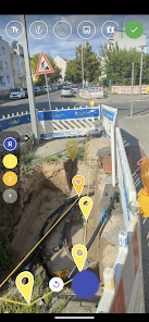
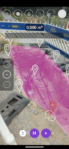
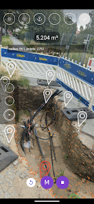
• Augmented reality surveying: Capture points, lines, and volumes directly in the camera image
• GNSS-supported surveying (requires 3tag GNSS hardware): Point, line, area, and DTM recording
• Stakeout via GNSS: Precise implementation of plan points in the terrain
• Map layer system: Integration of your own WMS and WMTS services possible
• Volume calculation from AR or GNSS data: Ideal for earthworks, excavation, or removal
Technical information:
• Android 7.0 or higher required
• AR Core support required: Check compatible devices
• 3tag GNSS hardware is required for GNSS functions
Further information: https://3tag.ai
What lies beneath the surface costs billions.
Errors, delays, damage – wherever pipes and cables are not visible.
3tag measures, documents, and makes them visible.
With 3tag, you can carry out surveying work in the field quickly, accurately, and completely digitally. Whether point or line measurement, volume recording, or terrain staking: the app offers professional tools that can be used intuitively even without extensive surveying training. Especially for smaller projects, the use of a classic surveyor is often unnecessary.
Ideal for:
• Network companies
• Gardening and landscaping
• Anyone who needs precise coordinates outdoors without complex measurement technology
Your advantages with 3tag:
✅ Simple and time-saving: Measure, document, and send digitally to the office—without any media discontinuity
✅ Results accurate to the centimeter: Measurements with up to 2 cm accuracy
✅ Directly georeferenced: All data is precisely tagged with coordinates
✅ PDF and export formats created automatically: DXF, ShapeFile, GeoCSV, and many more
Features at a glance:
• Augmented reality surveying: Capture points, lines, and volumes directly in the camera image
• GNSS-supported surveying (requires 3tag GNSS hardware): Point, line, area, and DTM recording
• Stakeout via GNSS: Precise implementation of plan points in the terrain
• Map layer system: Integration of your own WMS and WMTS services possible
• Volume calculation from AR or GNSS data: Ideal for earthworks, excavation, or removal
Technical information:
• Android 7.0 or higher required
• AR Core support required: Check compatible devices
• 3tag GNSS hardware is required for GNSS functions
Further information: https://3tag.ai
Updated on
Safety starts with understanding how developers collect and share your data. Data privacy and security practices may vary based on your use, region, and age. The developer provided this information and may update it over time.

No data shared with third parties
Learn more about how developers declare sharing

This app may collect these data types
Location, Personal info, and App info and performance

Data is encrypted in transit

You can request that data be deleted
What’s new
* Bug fixes
* Optimisations
* Optimisations
Everyone
Learn moreApp support
phone
Phone number
+4915170140582
About the developer
netpipe GmbH
hello@netpipe.io
Crusemarkstr. 9
13187 Berlin
Germany
+49 1517 0140582