
Tourenplaner SCHWEIZ
Contains adsIn-app purchases
10K+
Downloads

Everyone
info
About this app
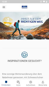
Get to your tour with just a few clicks
On the Tour Planner SWITZERLAND app you will find a wealth of hiking suggestions from all regions of Switzerland. Click through our theme worlds and get inspired! Whether challenging mountain tours, summit and hut experiences, family-friendly themed trails, short hikes for seniors, cultural city tours or winter and snowshoe hikes - the SWITZERLAND tour planner is the source of inspiration for your activities all year round!
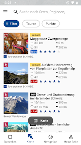
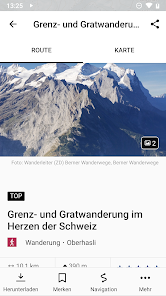
The editorial team of the magazine Wandermagazin SCHWEIZ is responsible for the content. Meaningful texts and images as well as regular updates ensure that the tour suggestions are of high quality. In addition to the detailed route description, all suggestions contain an elevation profile, technical information on hiking time, route length and height difference as well as tips and information on sights, refreshment stops and public transport stops.
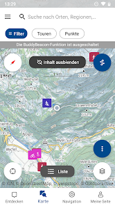
In addition to the Outdooractive map, other map bases, such as the Swisstopo map, can be used. Maps and tours can be saved offline using the app, so you can access your tour details anytime, anywhere. Thanks to the synchronization between app and web, your data is always up to date on all devices.
All tours are thematically clear and sorted by region. You can also plan your own hike from the comfort of your own home: To do this, first select an activity (e.g. hiking, mountaineering, cycling...) and then select the starting point and destination for your tour on the map. And the SWITZERLAND tour planner calculates the ideal route for you, including travel times, route length and altitude difference. Tour planning can be so easy!
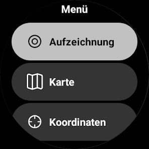
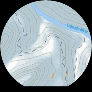
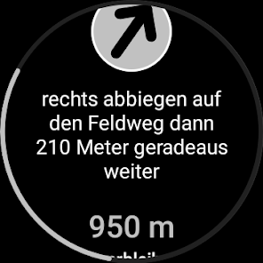
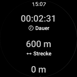
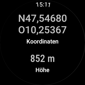
Smartwatches with WEAR OS by Google:
By looking at your smartwatch you get information about your position on the GPS map. You can record routes, read your tracking data and switch between different map types. Use the app tile for easy access to nearby tours.
Exclusively for Pro members
With Outdooractive Pro, maps and tours can be saved offline in the app, unlimited lists can be created and the app can be used ad-free. You will also receive a satellite map, the unique Outdooractive map with over 30 activity trail networks and the official topo maps from the following providers:
• Germany BKG
• Austria BEV
• Switzerland swisstopo
• France IGN
• Great Britain Ordnance Survey, Landranger, Explorer
• Spain CNIG
• Italy
• Netherlands PDOK
• Norway Kartverket
• Denmark Kortforsyningen
• Sweden Lantmäteriet
• Finland National Land Survey
• New Zealand Country Information
• Utah USGS
• Japan GSI
Exclusively for Pro+ members
Pro+ also contains the official maps of the Alpine clubs as well as premium maps from KOMPASS and certified premium tours from KOMPASS, Schall Verlag and ADAC hiking guides.
On the Tour Planner SWITZERLAND app you will find a wealth of hiking suggestions from all regions of Switzerland. Click through our theme worlds and get inspired! Whether challenging mountain tours, summit and hut experiences, family-friendly themed trails, short hikes for seniors, cultural city tours or winter and snowshoe hikes - the SWITZERLAND tour planner is the source of inspiration for your activities all year round!
The editorial team of the magazine Wandermagazin SCHWEIZ is responsible for the content. Meaningful texts and images as well as regular updates ensure that the tour suggestions are of high quality. In addition to the detailed route description, all suggestions contain an elevation profile, technical information on hiking time, route length and height difference as well as tips and information on sights, refreshment stops and public transport stops.
In addition to the Outdooractive map, other map bases, such as the Swisstopo map, can be used. Maps and tours can be saved offline using the app, so you can access your tour details anytime, anywhere. Thanks to the synchronization between app and web, your data is always up to date on all devices.
All tours are thematically clear and sorted by region. You can also plan your own hike from the comfort of your own home: To do this, first select an activity (e.g. hiking, mountaineering, cycling...) and then select the starting point and destination for your tour on the map. And the SWITZERLAND tour planner calculates the ideal route for you, including travel times, route length and altitude difference. Tour planning can be so easy!
Smartwatches with WEAR OS by Google:
By looking at your smartwatch you get information about your position on the GPS map. You can record routes, read your tracking data and switch between different map types. Use the app tile for easy access to nearby tours.
Exclusively for Pro members
With Outdooractive Pro, maps and tours can be saved offline in the app, unlimited lists can be created and the app can be used ad-free. You will also receive a satellite map, the unique Outdooractive map with over 30 activity trail networks and the official topo maps from the following providers:
• Germany BKG
• Austria BEV
• Switzerland swisstopo
• France IGN
• Great Britain Ordnance Survey, Landranger, Explorer
• Spain CNIG
• Italy
• Netherlands PDOK
• Norway Kartverket
• Denmark Kortforsyningen
• Sweden Lantmäteriet
• Finland National Land Survey
• New Zealand Country Information
• Utah USGS
• Japan GSI
Exclusively for Pro+ members
Pro+ also contains the official maps of the Alpine clubs as well as premium maps from KOMPASS and certified premium tours from KOMPASS, Schall Verlag and ADAC hiking guides.
Updated on
Safety starts with understanding how developers collect and share your data. Data privacy and security practices may vary based on your use, region, and age. The developer provided this information and may update it over time.


What's new
In dieser Version haben wir ein paar Fehler behoben und Verbesserungen vorgenommen.


