
Paragliding Map
Contains adsIn-app purchases
4.1star
1.32K reviews
100K+
Downloads

Everyone
info


About this app
The world's most popular free-flight app!
The most comprehensive source for site info, forecasts, webcams, photos & more!
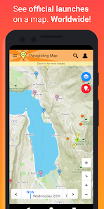
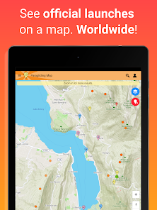
See where you can fly right now. Worldwide!
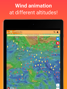
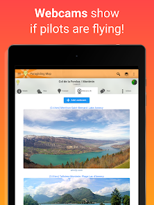
▪ Explore over 15,000 launch sites, 7,500 landings, 30,000 weather stations and 39,000 webcams.
▪ Official data from the DHV, Flyland, FFVL, Paragliding Earth and more.
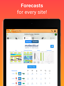
▪ Forecasts from Meteoblue, Windy and WindFinder.
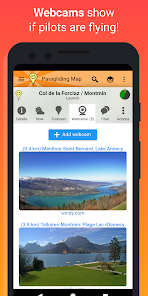
▪ Live webcams.
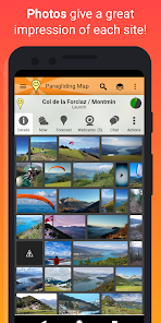
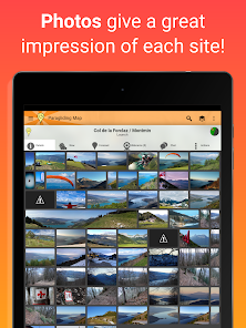
▪ Photos give you a great impression of each spot.
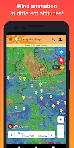
▪ Wind animation - View clouds, thunderstorms, rain and wind at different altitudes.
▪ Airspace and NOTAMs (short-term, daily airspace restrictions).
▪ Filter the map to show only launches for paragliding, hang gliding, speed flying, thermalling, soaring, hike & fly, public transport, wind speed and much more!
▪ See soaring index, cloud cover, weather warnings and much more!
▪ Many forecast providers: UK MetOffice, German Weather Service, Meteo France, meteoblue, ECMWF, NOAA and others!
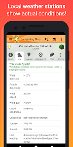
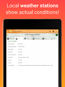
▪ Real-time weather station data from Pioupiou, Holfuy, MADIS and FFVL show you actual weather conditions.
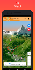
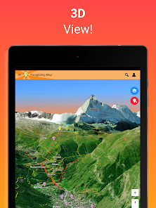
▪ 3D view.
▪ "Hike & fly" trails.
▪ Ski lifts, cable cars and gondolas.
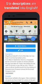
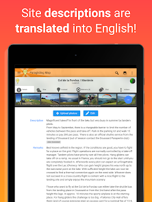
▪ Automatic translation of site descriptions into English.
▪ View the map as it will appear in the future.
▪ Driving directions to each spot using navigation.
▪ Favourites can be saved for easy access later.
▪ Advanced search.
▪ Send “SOS!” and “I need a ride” messages to friends, including your GPS coordinates.
▪ Links to original info from the DHV, Flyland, FFVL und Paragliding Earth.
▪ Easily share spot and map details via Facebook, Twitter, messages and email.
▪ No advertising.
▪ Full support included.
Your feedback is always welcome. Help us to make the best paragliding app in the world!
Many feature of Paragliding Map are free but supported by advertising. If you choose to make any in-app purchase, advertising will automatically turn off and your purchase will be enabled (webcams, forecasts, etc).
Paragliding Map is the mobile version of ParaglidingMap.com.
Privacy policy and terms and conditions can be found at https://www.paraglidingmap.com/TermsAndConditions.aspx
The most comprehensive source for site info, forecasts, webcams, photos & more!
See where you can fly right now. Worldwide!
▪ Explore over 15,000 launch sites, 7,500 landings, 30,000 weather stations and 39,000 webcams.
▪ Official data from the DHV, Flyland, FFVL, Paragliding Earth and more.
▪ Forecasts from Meteoblue, Windy and WindFinder.
▪ Live webcams.
▪ Photos give you a great impression of each spot.
▪ Wind animation - View clouds, thunderstorms, rain and wind at different altitudes.
▪ Airspace and NOTAMs (short-term, daily airspace restrictions).
▪ Filter the map to show only launches for paragliding, hang gliding, speed flying, thermalling, soaring, hike & fly, public transport, wind speed and much more!
▪ See soaring index, cloud cover, weather warnings and much more!
▪ Many forecast providers: UK MetOffice, German Weather Service, Meteo France, meteoblue, ECMWF, NOAA and others!
▪ Real-time weather station data from Pioupiou, Holfuy, MADIS and FFVL show you actual weather conditions.
▪ 3D view.
▪ "Hike & fly" trails.
▪ Ski lifts, cable cars and gondolas.
▪ Automatic translation of site descriptions into English.
▪ View the map as it will appear in the future.
▪ Driving directions to each spot using navigation.
▪ Favourites can be saved for easy access later.
▪ Advanced search.
▪ Send “SOS!” and “I need a ride” messages to friends, including your GPS coordinates.
▪ Links to original info from the DHV, Flyland, FFVL und Paragliding Earth.
▪ Easily share spot and map details via Facebook, Twitter, messages and email.
▪ No advertising.
▪ Full support included.
Your feedback is always welcome. Help us to make the best paragliding app in the world!
Many feature of Paragliding Map are free but supported by advertising. If you choose to make any in-app purchase, advertising will automatically turn off and your purchase will be enabled (webcams, forecasts, etc).
Paragliding Map is the mobile version of ParaglidingMap.com.
Privacy policy and terms and conditions can be found at https://www.paraglidingmap.com/TermsAndConditions.aspx
Updated on
Safety starts with understanding how developers collect and share your data. Data privacy and security practices may vary based on your use, region, and age. The developer provided this information and may update it over time.


Ratings and reviews
4.1
1.23K reviews

Barry Morse
- Flag inappropriate
July 16, 2022
Installed and was repeatedly blocked by a full page ad with a long delay before I could "X" out of it and get back into the app. Over and over... Another pilot kept referring to this app, saying it would be flyable at a certain time, or the winds would be this at another time. Those forecasts were wildly incorrect. I don't "look for places to fly," so the default map view of sites would have little value.
4 people found this review helpful
Paragliding Map
July 17, 2022
We offer forecasts from Windy, Meteoblue and Windfinder, so you can take your pick as to which forecast service is most accurate for your area. 👍
It's possible to remove ads by subscribing, which also gives you access to advanced forecasts, photos, webcams and different map types.

lucien simon
- Flag inappropriate
February 12, 2021
Craig is available and super helpful when support is needed. This is an extremely useful app , directions to launch work and everything else is pretty much correct. Obviously cross check the weather conditions on the day, flyable directions are right but true wind speeds can vary considerably. This is almost the complete guide in your pocket! Thank you Craig, you've created a fine tool here.
6 people found this review helpful

Paul Yorke
- Flag inappropriate
June 10, 2020
Update 2020: this is still my Go To app when travelling or abroad, and at home to. Lots have been added and updated so try it again if you weren't sure B4 100% worth paying the subscription especially when travelling even if you just pay for the month while on holiday. I love this app. Makes life so much easier seeing everything at a glance. Links to more detailed sites if you want to get more in depth info. Had an issue but Craig sorted it out incredibly quickly. Well worth the money :D :D .
1 person found this review helpful
What's new
- Filter the map to show only launches for paragliding, hang gliding, speed flying, thermalling, soaring, hike & fly, public transport, wind speed and much more!
- Bugfixes and improvements.
- Bugfixes and improvements.