GRIS
1K+
Downloads

Everyone
info


About this app
Objectives
The capitalised GIS intelligence in planning and monitoring activities, the GIS Section of LGED will develop a mobile app to perform GIS based survey primarily for roads including a monitoring system of development schemes. This app will also facilitate to update geo-coordinates of road network as well as monitoring scheme implementation progress through online geo-tagged photo capturing system.
Description
Despite the goal of making data collection process more effective, easy and quickest way, mobile based geo-computing applications are a means to control data quality during data collection. Mobile GIS tools can support data quality through functions that control simultaneously the data entered by field surveyors. Semantic integrity of the database can be achieved through semantic plausibility controls that avoid occurrence of inconsistency.
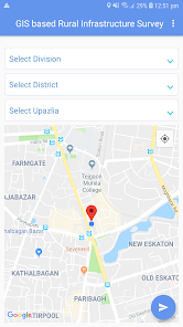
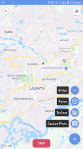
The GIS based road survey mobile app allows field surveyors to capture latitude and longitude data continuously while survey a road by any transportation media. It also allows to capture geo-tagging image as well as other information of any feature during survey. The use is able to view capture images and surveyed road layer from both mobile app and web application for effective decision support activities.
The capitalised GIS intelligence in planning and monitoring activities, the GIS Section of LGED will develop a mobile app to perform GIS based survey primarily for roads including a monitoring system of development schemes. This app will also facilitate to update geo-coordinates of road network as well as monitoring scheme implementation progress through online geo-tagged photo capturing system.
Description
Despite the goal of making data collection process more effective, easy and quickest way, mobile based geo-computing applications are a means to control data quality during data collection. Mobile GIS tools can support data quality through functions that control simultaneously the data entered by field surveyors. Semantic integrity of the database can be achieved through semantic plausibility controls that avoid occurrence of inconsistency.
The GIS based road survey mobile app allows field surveyors to capture latitude and longitude data continuously while survey a road by any transportation media. It also allows to capture geo-tagging image as well as other information of any feature during survey. The use is able to view capture images and surveyed road layer from both mobile app and web application for effective decision support activities.
Updated on
Data safety
Developers can show information here about how their app collects and uses your data. Learn more about data safety

No information available
What's new
Release new version 2.6


