
My Elevation
Contains ads
4.7star
23K reviews
1M+
Downloads

Everyone
info


About this app
My Elevation uses web services to get your precise surface elevation based on your current location. This is far more accurate than the elevation data provided by your device. But there's so much more you can do with My Elevation. Try it and see!
Notes:
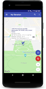
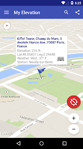
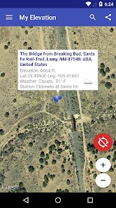
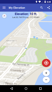
● The application shows the surface elevation above sea level based a latitude and longitude. It does not provide altitude in cases where you are in an aircraft, high up in a building, or high off of ground for some reason.
● This application must have a working data connection to be able to show your position on the map, get your precise elevation and provide much additional rich content . It does not have an off line mode. Please consider this before giving poor ratings when it doesn't work when you have no data connection.
Feature List
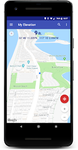
● Follow Me Mode - Follows your current location in real time. Watch your movements on a map and see your elevation and coordinates updating as you move.
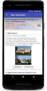
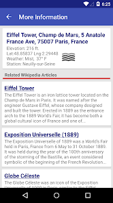
● Search for Locations and watch the map fly over to them. My Elevation will tell you the weather there and let you browse Wikipedia articles about attractions nearby the location. If you are curious at all about other places you will love this !
● Long press a location on the map and My Elevation will tell you the weather there and let you browse Wikipedia articles about attractions nearby the location.
● Add bookmarks for places you want to remember.
● Share your location or what you find in searches with your friends in a text or email.
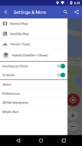
Display Options
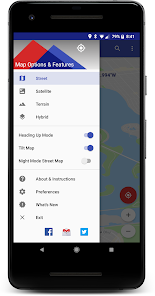
Map Mode - Lets you pick one of four Google Map types (Normal, Satellite, Topo and Hybrid)
Heading Up, Map Tilt and Night Mode
Try it out and let us know how it goes.
email us at rdhsoftware@gmail.com
or visit https://www.facebook.com/MyElevation
This application uses Google Analytics to collect anonymous data about how the application is used and what failures occur. This allows us to make the application better with each release. You can opt out of this by un-checking the Analytics data item in the application preferences. No personally identifying information is collected.
Notes:
● The application shows the surface elevation above sea level based a latitude and longitude. It does not provide altitude in cases where you are in an aircraft, high up in a building, or high off of ground for some reason.
● This application must have a working data connection to be able to show your position on the map, get your precise elevation and provide much additional rich content . It does not have an off line mode. Please consider this before giving poor ratings when it doesn't work when you have no data connection.
Feature List
● Follow Me Mode - Follows your current location in real time. Watch your movements on a map and see your elevation and coordinates updating as you move.
● Search for Locations and watch the map fly over to them. My Elevation will tell you the weather there and let you browse Wikipedia articles about attractions nearby the location. If you are curious at all about other places you will love this !
● Long press a location on the map and My Elevation will tell you the weather there and let you browse Wikipedia articles about attractions nearby the location.
● Add bookmarks for places you want to remember.
● Share your location or what you find in searches with your friends in a text or email.
Display Options
Map Mode - Lets you pick one of four Google Map types (Normal, Satellite, Topo and Hybrid)
Heading Up, Map Tilt and Night Mode
Try it out and let us know how it goes.
email us at rdhsoftware@gmail.com
or visit https://www.facebook.com/MyElevation
This application uses Google Analytics to collect anonymous data about how the application is used and what failures occur. This allows us to make the application better with each release. You can opt out of this by un-checking the Analytics data item in the application preferences. No personally identifying information is collected.
Updated on
Safety starts with understanding how developers collect and share your data. Data privacy and security practices may vary based on your use, region, and age. The developer provided this information and may update it over time.


Ratings and reviews
4.7
22.5K reviews

Keith Nielsen
- Flag inappropriate
- Show review history
July 11, 2024
Elevation and GPS coordinates of your current location appears. You can pin any point on the map to know the exact address if there is one, elevation, GPS coordinates, the current local temperature, and the city used to obtain that temperature. The available pop-up lists 12 local points of interest with photo and the number of miles to each point allowing you to see it on the map or open the web page if there is one related to that point of interest. EASY TO USE. Wow!
3 people found this review helpful

Gregory Balcom
- Flag inappropriate
June 7, 2021
I think this app is fantastic! It's very easy to use, accurate and loaded with information. The interface could define the term "intuitive", it's that good. (Microsoft, take a lesson). I've tried other elevation software but nothing I've tried even comes close to to My Elevation in terms of speed, accuracy, volume of practical information included, number of alternative views available and overall design. I love it!
184 people found this review helpful
RDH Software
June 9, 2021
Thanks Gregory! We appreciate your taking the time to write such a thoughtful review.

A Google user
- Flag inappropriate
August 28, 2019
Good App - No way to upgrade. I installed free version, used it for a few days then attempted to buy it but no option to do it. You only get that option before you buy it. Once you try it, you can't buy it. Too bad ...... uninstalling, and looking for another app. Also the search feature does not work. When you enter the address there is no button to start the search.
49 people found this review helpful
What's new
New search providers.
Library updates and bug fixes.
Library updates and bug fixes.