
El Camí
1K+
Downloads

Everyone
info

About this app
The Path is a hiking trail cultural with a continuous line and signposted, linking roads and existing routes in all regions and islands speaks Catalan, allowing you to learn experientially culture, history, landscape and people of every ground.
It is designed so that everyone can do on their own, making sure your measurement stages (see route finder and special sections). You can also join the Group Walkers.
The whole of the Way of the Catalan Countries already georeferenced, and some sections are marked with the brand of the road. All can be followed through the mobile app yet (look for the way to the banner of routes promodionades the app).
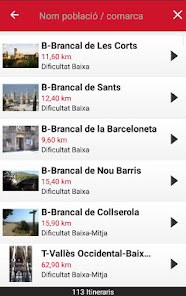
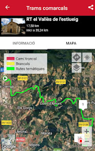
The Way began in 2003 and consists of about 4,700 km (or main trunk road, marked with the red mark), plus the jambs that probe other municipalities in each region (yellow mark) and who creating progressively.
The Way is a collaborative project, everyone can participate in different ways, and also to send texts or post to Camipèdia activities on the cover.
Is recognized by the Parliament of Catalonia (resolution) and the Parliament of the Balearic Islands as a project of national cultural and tourist interest.
It is designed to make it on foot, and many sections are ciclables (will be gradually indicating the sections that are not, that task will need the collaboration of each carers section).
All The Way is already georeferenced. The road is signposted collaboratively with the people of the territory under the brand hiker's path. The project is alive, still signaling process with the whole country and all its people as protagonists and beneficiaries. These organizations, institutions and residents of each municipality and county who define their stretch of road, the contents of the guide and the resources and services that include.
To enjoy by yourself the experience of exploring on foot all our towns and counties, just pick a section and follow the path marks, or download the mobile georeferenced route (the sections not marked) .
Designed for all ages and ages, with a degree of difficulty mostly low or middle, he can make everyone in their size and level.
The road connects all the heads of the region, taking a form of irregular eight crosses in Montserrat, visiting villages to see firsthand its people, their reality and social initiatives, culture, art, customs, festivals and traditions, geography, landscapes, nature, ...
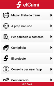
The section How to follow the path you will find different ways to do the Camino.
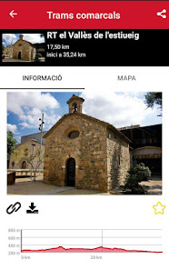
Guides the Way. There are published guidelines on the role of six of the 32 sections of trunk road (each section between the second and fourth regions). Gradually, it is expected to bring out all the guides.
It is designed so that everyone can do on their own, making sure your measurement stages (see route finder and special sections). You can also join the Group Walkers.
The whole of the Way of the Catalan Countries already georeferenced, and some sections are marked with the brand of the road. All can be followed through the mobile app yet (look for the way to the banner of routes promodionades the app).
The Way began in 2003 and consists of about 4,700 km (or main trunk road, marked with the red mark), plus the jambs that probe other municipalities in each region (yellow mark) and who creating progressively.
The Way is a collaborative project, everyone can participate in different ways, and also to send texts or post to Camipèdia activities on the cover.
Is recognized by the Parliament of Catalonia (resolution) and the Parliament of the Balearic Islands as a project of national cultural and tourist interest.
It is designed to make it on foot, and many sections are ciclables (will be gradually indicating the sections that are not, that task will need the collaboration of each carers section).
All The Way is already georeferenced. The road is signposted collaboratively with the people of the territory under the brand hiker's path. The project is alive, still signaling process with the whole country and all its people as protagonists and beneficiaries. These organizations, institutions and residents of each municipality and county who define their stretch of road, the contents of the guide and the resources and services that include.
To enjoy by yourself the experience of exploring on foot all our towns and counties, just pick a section and follow the path marks, or download the mobile georeferenced route (the sections not marked) .
Designed for all ages and ages, with a degree of difficulty mostly low or middle, he can make everyone in their size and level.
The road connects all the heads of the region, taking a form of irregular eight crosses in Montserrat, visiting villages to see firsthand its people, their reality and social initiatives, culture, art, customs, festivals and traditions, geography, landscapes, nature, ...
The section How to follow the path you will find different ways to do the Camino.
Guides the Way. There are published guidelines on the role of six of the 32 sections of trunk road (each section between the second and fourth regions). Gradually, it is expected to bring out all the guides.
Updated on
Safety starts with understanding how developers collect and share your data. Data privacy and security practices may vary based on your use, region, and age. The developer provided this information and may update it over time.

No data shared with third parties
Learn more about how developers declare sharing

No data collected
Learn more about how developers declare collection

Data is encrypted in transit

Data can’t be deleted
What's new
- Millores de privacitat