
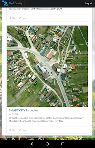
SMART CITY Inspector
100+
Downloads

Everyone
info


About this app
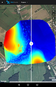
SMART CITY Inspector analyzes RGB data, DSM, DTM or thermal data from drones and aircraft captured images. The app brings you solutions relating to water management, smart data analysis and smart planning for the future of cities. Recommended for city builders, environmentalists, spatial planners and others.
The mobile application comes from a desktop solution that is available for you and your clients, too. For more information about technical specification and workflow, please send request to info@tmgdronity.com.
Features:
- Smart governance of cities
- Fast area and distance measuring
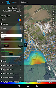
- 1 cm/pixel ORTHOMOSAIC, DSM, DTM
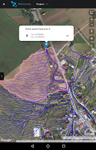
- Hydrological analysis - drainage network and watershed areas
- Set transparency layers
- Onscreen review of existing data
- Multiple coordinate formats
- Smart Marker Mode for super accurate pin placement
- Markers can contain different types of files (archives, images, documents)
- Base map : Satellite, Terrain, Roadmap and Hybrid modes
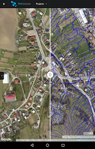
- Fast comparing layers and monitoring of changes in time
- Vector data - cadastre boundaries for instance
- Ability to share your maps
- Detection of objects temperature on the site
Technical Features:
- No ads
- Minimum permission
Discover our web and services, including rates : https://tmgdronity.com
The mobile application comes from a desktop solution that is available for you and your clients, too. For more information about technical specification and workflow, please send request to info@tmgdronity.com.
Features:
- Smart governance of cities
- Fast area and distance measuring
- 1 cm/pixel ORTHOMOSAIC, DSM, DTM
- Hydrological analysis - drainage network and watershed areas
- Set transparency layers
- Onscreen review of existing data
- Multiple coordinate formats
- Smart Marker Mode for super accurate pin placement
- Markers can contain different types of files (archives, images, documents)
- Base map : Satellite, Terrain, Roadmap and Hybrid modes
- Fast comparing layers and monitoring of changes in time
- Vector data - cadastre boundaries for instance
- Ability to share your maps
- Detection of objects temperature on the site
Technical Features:
- No ads
- Minimum permission
Discover our web and services, including rates : https://tmgdronity.com
Updated on
Safety starts with understanding how developers collect and share your data. Data privacy and security practices may vary based on your use, region, and age. The developer provided this information and may update it over time.

No data shared with third parties
Learn more about how developers declare sharing

No data collected
Learn more about how developers declare collection