Soilsens™ FARMER APP
100+
Downloads

Everyone
info
About this app
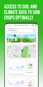
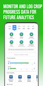
FARMER © ( Farmer Accessible Resource Management And Easy Recommendations) app is made for farmers to easily access weather forecast data, soil nutrient and moisture data, satellite data, crop data, and farm data and get advisories instantly under one platform. . FARMER app also allows farmers to monitor their crop progress and log their activities easily for future analysis.
This app is also interfaced with Soilsens’s hardware devices MoistureSensGo – a smart moisture meter for controlled irrigation and NutriSens – a rapid soil testing device for quick soil health tests and balanced fertilizer recommendations.
Why is the FARMER © App important for farmers?
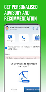
Our comprehensive Soilsens FARMER app helps farmers to manage farms with ease, connects with our devices to get soil health details quickly with complete agronomy advisories, and saves data on the cloud for future reference. Farmers can also connect with experts for customized advisory.
How can FARMER app and Nutrisens help rural youth and women farmers?
Rural youth and SHGs can use our instant soil testing device NutriSens and FARMER app to provide quick soil testing to farmers at their doorstep. This will help in generating employment for themselves and achieve many of the UNDP sustainability goals.
This app is also interfaced with Soilsens’s hardware devices MoistureSensGo – a smart moisture meter for controlled irrigation and NutriSens – a rapid soil testing device for quick soil health tests and balanced fertilizer recommendations.
Why is the FARMER © App important for farmers?
Our comprehensive Soilsens FARMER app helps farmers to manage farms with ease, connects with our devices to get soil health details quickly with complete agronomy advisories, and saves data on the cloud for future reference. Farmers can also connect with experts for customized advisory.
How can FARMER app and Nutrisens help rural youth and women farmers?
Rural youth and SHGs can use our instant soil testing device NutriSens and FARMER app to provide quick soil testing to farmers at their doorstep. This will help in generating employment for themselves and achieve many of the UNDP sustainability goals.
Updated on
Safety starts with understanding how developers collect and share your data. Data privacy and security practices may vary based on your use, region, and age. The developer provided this information and may update it over time.

No data shared with third parties
Learn more about how developers declare sharing

This app may collect these data types
Location, Personal info and 2 others

Data is encrypted in transit

You can request that data be deleted
What's new
Release notes:
1. Empowered users to modify field names and geographic coordinates (latitude and longitude).
2. Enhanced geo-tagging functionality through latitude and longitude-based search capabilities.
3. Integrated graphical representations of rainfall and temperature data into the Soil Testing module.
1. Empowered users to modify field names and geographic coordinates (latitude and longitude).
2. Enhanced geo-tagging functionality through latitude and longitude-based search capabilities.
3. Integrated graphical representations of rainfall and temperature data into the Soil Testing module.