WinGPS™ Marine
In-app purchases

3.4star
1.2K reviews
100K+
Downloads

Everyone
info


About this app
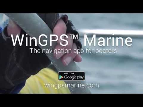
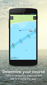
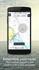
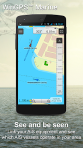
WinGPS Marine offers you modern, easy to learn navigational tools for a safe trip. Long press on the chart to plot your route. The GPS on board will show your exact location. Download the charts to your device and go boating offline with the most up-to-date charts. Connect your AIS via WIFI and prevent possible collisions.
Developed by Stentec for navigation on sailing and motor yachts, sloops and canoes at sea, tidal and inland waters. Ideal when renting or chartering a boat.
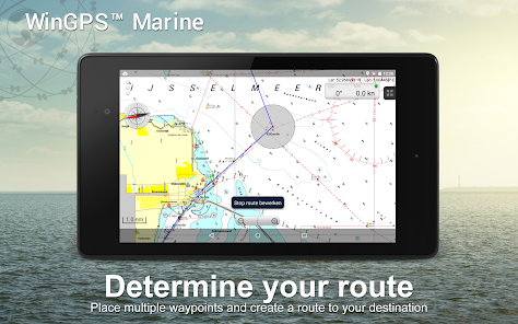
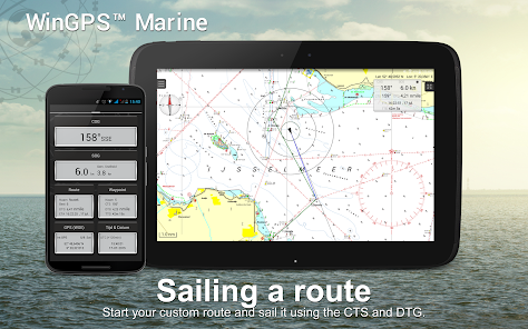
• Support for the waterways for the inland charts Western Europe and Donau with bridge-, locks and waterway information. With this you can plot and adjust your routes quickly, indicating any obstacles. The names of the waterways and distances will be shown during your trip.
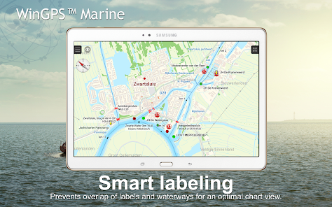
• Smart labeling prevents overlapping text labels (with waterways also) for an optimal chart image. Bridge and lock data will always be readable on Course Up rotating charts.
HIGHLIGHTS
• Navigating on up-to-date charts of Stentec, Imray, NOAA and Delius Klasing.
• SD-card support for chart storage.
• Manage tracks, charts, routes and waypoints.
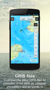
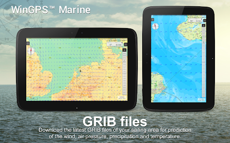
• NOAA World GRIB-files: wind, air pressure, rainfall and temperature.
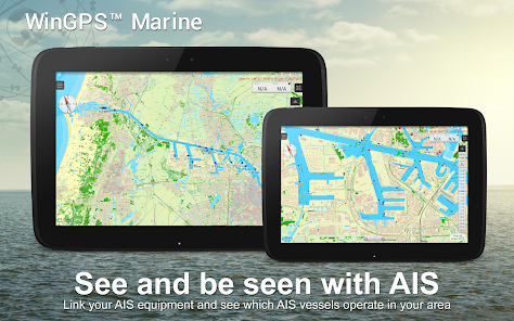
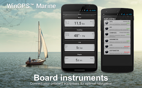
• Connect AIS and GPS via wirelesss WIFI or Bluetooth connection.
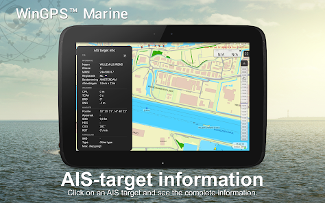
• Prevent collisions with the speed vectors of the AIS ships.
• Man-overboard button helps to retrieve lost crewmembers.
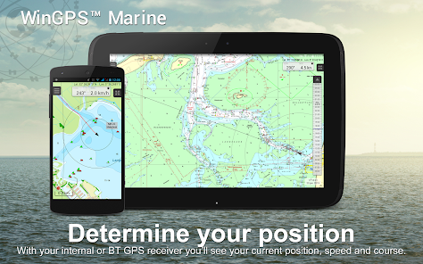
• Chart moves along underneath centered GPS position. NorthUp, CourseUp (Marine) or HeadUp (Plus).
• Harmoniemodel KNMI with detailed weather predictions (Plus, Netherlands only)
• NOAA wave prediction at open sea (Plus, Worldwide)
When WinGPS Marine is installed for the first time, this will be WinGPS Marine Lite with limited functions. Ideal as a chart viewer with GPS support.
IN-APP PURCHASE
After putchasing WinGPS Marine, you will unlock the full capabilities of your personal navigation system. You are now able to plot routes, download GRIB files, save previous tracks and connect AIS and GPS. Use the handy time table to view the predicted wind, rain, air pressure and AIS targets.
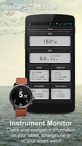
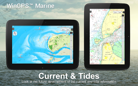
With the WinGPS Marine Plus upgrade, you will be able to connect additional board instruments via wireless connection to you board PC, multiplexer or AIS transponder. You can display current and tidal information in your data plotter or view it on the chart. Also, the advanced KNMI’s Harmonie weather model is supported as well as the NOAA waves worldwide.
KUSTFIJN Getijmodel Rijkswaterstaat with two day wind depended predictions of currents, tides and water levels on the Waddenzee, Ijsselmeer, Markermeer, Randmeren and Zeeland. Red depth lines limit the safe waterways depending on depth, tides and deviations because of the wind.
CHART COVERAGE & INSTALLING THE CHARTS
When you start WinGPS Marine you will automatically see the (online) topographic default chart of ESRI. You can also turn on the NOAA charts of the US and download the free world chart via the Chart Manager
For safe navigation, you can purchase digital charts at www.stentec.com. It’s also possible to purchase the charts in the app or via Google Play™. Your charts can be installed on 3 different devices. For example, on your Android tablet, phone and Windows laptop or computer.
Log in with your Stentec Account in the Marine app and download or update your purchased DKW2 charts in the Chart Manager.
For example, the popular DKW1800 series with weekly BaZ updates and the NL Chart with biweekly updates. Our online shop offers up-to-date sea charts and all inland charts of Western Europa including the Donau.
More information:
www.wingpsmarine.com
Privacy policy:
www.stentec.com/en/en/privacy-statement
USERS INPUT
For improvement of the app we are very much interested in your experience and suggestions. Please send an e-mail to helpdesk@stentec.com.
Developed by Stentec for navigation on sailing and motor yachts, sloops and canoes at sea, tidal and inland waters. Ideal when renting or chartering a boat.
• Support for the waterways for the inland charts Western Europe and Donau with bridge-, locks and waterway information. With this you can plot and adjust your routes quickly, indicating any obstacles. The names of the waterways and distances will be shown during your trip.
• Smart labeling prevents overlapping text labels (with waterways also) for an optimal chart image. Bridge and lock data will always be readable on Course Up rotating charts.
HIGHLIGHTS
• Navigating on up-to-date charts of Stentec, Imray, NOAA and Delius Klasing.
• SD-card support for chart storage.
• Manage tracks, charts, routes and waypoints.
• NOAA World GRIB-files: wind, air pressure, rainfall and temperature.
• Connect AIS and GPS via wirelesss WIFI or Bluetooth connection.
• Prevent collisions with the speed vectors of the AIS ships.
• Man-overboard button helps to retrieve lost crewmembers.
• Chart moves along underneath centered GPS position. NorthUp, CourseUp (Marine) or HeadUp (Plus).
• Harmoniemodel KNMI with detailed weather predictions (Plus, Netherlands only)
• NOAA wave prediction at open sea (Plus, Worldwide)
When WinGPS Marine is installed for the first time, this will be WinGPS Marine Lite with limited functions. Ideal as a chart viewer with GPS support.
IN-APP PURCHASE
After putchasing WinGPS Marine, you will unlock the full capabilities of your personal navigation system. You are now able to plot routes, download GRIB files, save previous tracks and connect AIS and GPS. Use the handy time table to view the predicted wind, rain, air pressure and AIS targets.
With the WinGPS Marine Plus upgrade, you will be able to connect additional board instruments via wireless connection to you board PC, multiplexer or AIS transponder. You can display current and tidal information in your data plotter or view it on the chart. Also, the advanced KNMI’s Harmonie weather model is supported as well as the NOAA waves worldwide.
KUSTFIJN Getijmodel Rijkswaterstaat with two day wind depended predictions of currents, tides and water levels on the Waddenzee, Ijsselmeer, Markermeer, Randmeren and Zeeland. Red depth lines limit the safe waterways depending on depth, tides and deviations because of the wind.
CHART COVERAGE & INSTALLING THE CHARTS
When you start WinGPS Marine you will automatically see the (online) topographic default chart of ESRI. You can also turn on the NOAA charts of the US and download the free world chart via the Chart Manager
For safe navigation, you can purchase digital charts at www.stentec.com. It’s also possible to purchase the charts in the app or via Google Play™. Your charts can be installed on 3 different devices. For example, on your Android tablet, phone and Windows laptop or computer.
Log in with your Stentec Account in the Marine app and download or update your purchased DKW2 charts in the Chart Manager.
For example, the popular DKW1800 series with weekly BaZ updates and the NL Chart with biweekly updates. Our online shop offers up-to-date sea charts and all inland charts of Western Europa including the Donau.
More information:
www.wingpsmarine.com
Privacy policy:
www.stentec.com/en/en/privacy-statement
USERS INPUT
For improvement of the app we are very much interested in your experience and suggestions. Please send an e-mail to helpdesk@stentec.com.
Updated on
Safety starts with understanding how developers collect and share your data. Data privacy and security practices may vary based on your use, region, and age. The developer provided this information and may update it over time.

No data shared with third parties
Learn more about how developers declare sharing

This app may collect these data types
Personal info

Data is encrypted in transit

You can request that data be deleted
Ratings and reviews
3.5
921 reviews

A Google user
- Flag inappropriate
- Show review history
May 28, 2019
need to buy a chart before doing anything. search at website didn't work.. blank screen and reload didn't work. should have a bare minimum chart so we can see how it works as it seems to have much potential. Update: developer responded quickly with charts to download and options, which I did try unsuccessfully. My point to them is to include one chart, I don't care if it's eastside Kazakhstan but then we can proceed and evaluate whether to proceed.
50 people found this review helpful
Stentec
September 29, 2020
edit- Sorry to hear you did not succes installing the free chart. If you would like any help with this, you can contact our helpdesk.

Fish Finder
- Flag inappropriate
June 17, 2020
Looks ok, a bit clunky, can not get waypoints or names to display over base chart? Cannot find an import gpx option. Needs work.
32 people found this review helpful
Stentec
September 28, 2020
Thank you for the feedback. It is possible to import GPX. Just safe the GPX file on your device and open the file. Your device will ask which app you would like to use, then select WinGPS Marine and the file is imported. Regarding your question about the waypoints and names on the base chart, please contact our helpesk.

Morris Rogers
- Flag inappropriate
May 16, 2024
I find it very clear to read an understand
Stentec
May 21, 2024
Thanks for your nice rating! If there is anything else we can do for you, feel free to contact us at stentec@stentec.com
What's new
Version 4.67
- NMEA message HDM added: Magnetic compass heading.
- Waterway Network enabled for DK charts.
- Sharper charts on high resolution devices.
- Fix for CTS when using a navigation waypoint.
- NMEA message HDM added: Magnetic compass heading.
- Waterway Network enabled for DK charts.
- Sharper charts on high resolution devices.
- Fix for CTS when using a navigation waypoint.


