
Water Map Live - Routes, AIS
In-app purchases
100K+
Downloads

Everyone
info


About this app
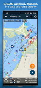
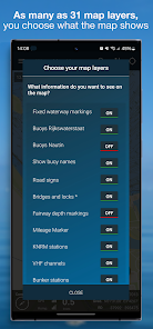
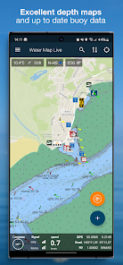
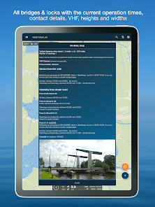
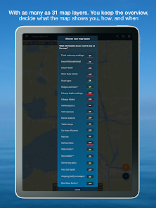
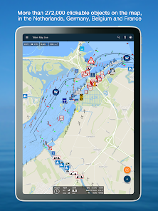
This is by far the most complete waterway and boating chart of the Netherlands, Belgium and Germany. With all fairway features, buoyage, traffic signs and *live* bridges and locks: opening times, telephone numbers and VHF radio channels. More than 272.000 objects on the map, conveniently arranged in map layers that you can switch on and off as desired.
All water charts can be downloaded and used offline.
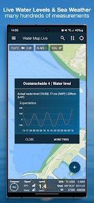
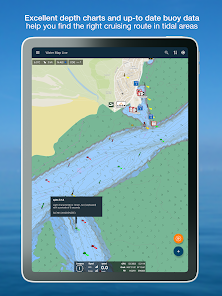
The app really is LIVE and contains hundreds of current water levels, tidal curves, the weather at sea and in your area, water depths, data from KNRM stations and the water quality of countless Dutch bathing places. And the current notices to skippers (NtS): are there any obstructions on your route? You know it now. Always up to date.
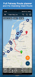
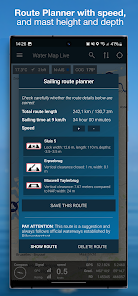
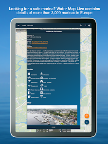
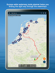
In total, the app contains the data of more than one hundred thousand nautical objects that are shown on the map around you. Thanks to GPS you can also read your speed and current coordinates. With the GPS tracker you can record and save your routes.
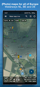
The app is based on map material from the Dutch Land Registry and also contains the beautiful 1: 25,000 topographical maps of the Netherlands.
Water Map Live is excellent for offline use, but the live information about bridges & locks, NtS, the current water levels and the current weather naturally uses an internet connection.
Conditions.
We do our utmost to deliver a fantastic and accurate water map app, but of course we cannot guarantee that the software and the data presented therein will always work and are 100% correct. Data sources can sometimes change and you cannot derive any rights from this app or the information presented therein. Usage of course is on your own risk. By downloading and using this water map app you accept these terms and conditions.
Location
The location permission is only needed to show you the current location and related information in your area. Surfcheck does not use this location data in any other way.
All water charts can be downloaded and used offline.
The app really is LIVE and contains hundreds of current water levels, tidal curves, the weather at sea and in your area, water depths, data from KNRM stations and the water quality of countless Dutch bathing places. And the current notices to skippers (NtS): are there any obstructions on your route? You know it now. Always up to date.
In total, the app contains the data of more than one hundred thousand nautical objects that are shown on the map around you. Thanks to GPS you can also read your speed and current coordinates. With the GPS tracker you can record and save your routes.
The app is based on map material from the Dutch Land Registry and also contains the beautiful 1: 25,000 topographical maps of the Netherlands.
Water Map Live is excellent for offline use, but the live information about bridges & locks, NtS, the current water levels and the current weather naturally uses an internet connection.
Conditions.
We do our utmost to deliver a fantastic and accurate water map app, but of course we cannot guarantee that the software and the data presented therein will always work and are 100% correct. Data sources can sometimes change and you cannot derive any rights from this app or the information presented therein. Usage of course is on your own risk. By downloading and using this water map app you accept these terms and conditions.
Location
The location permission is only needed to show you the current location and related information in your area. Surfcheck does not use this location data in any other way.
Updated on
Safety starts with understanding how developers collect and share your data. Data privacy and security practices may vary based on your use, region, and age. The developer provided this information and may update it over time.


What's new
V9.8 - Some updates to the database and buoy positions. Thanks for the notifications!


