Maastokartat
In-App-Käufe
4.1star
20.6 Tsg. Rezensionen
500 Tsg.+
Downloads

Jedes Alter
info
Über diese App
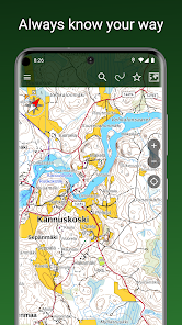
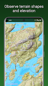
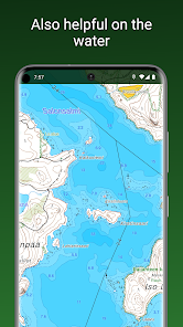
Free topographic map enhances outdoor activities and aids in the exploration of new places. It enables you to effortlessly determine your location and understand your surroundings. You can save interesting places and navigate to various destinations. By subscribing to Maastokartat Plus, you gain access to valuable additional features, including high-definition topographic maps with elevation and depth details, 3D maps, property boundaries, route planning and tracking, offline maps, and location sharing.
Free features:
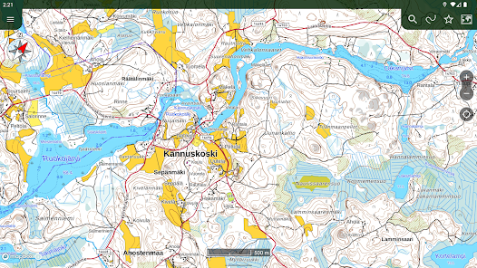
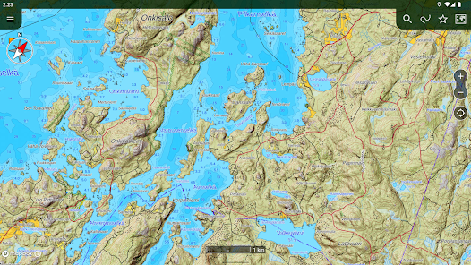
• Accurate topographic map based on data from the National Land Survey of Finland
• Aerial imagery from the National Land Survey of Finland
• Satellite images of the entire world
• Topographic maps of Sweden, Norway, Denmark, and Estonia
• Display and tracking of your location
• Coordinate display formats: WGS84, ETRS-TM35FIN, YKJ, KKJ, and MGRS
• Compass, map rotation based on direction of travel
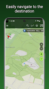
• Navigation to a destination, displaying direction and distance
• Place name search
• Distance measurement
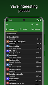
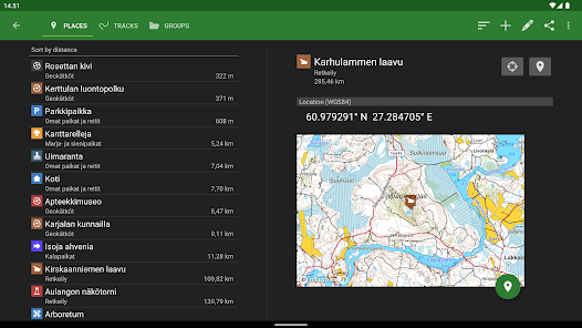
• Saving your own places
• Organizing places and routes into groups
• Sharing and importing places and routes as GPX files
• Backup to your personal Google Drive
• Heart rate monitoring with BLE heart rate sensors
Plus subscription additionally includes:
• Highly detailed topographic map with water depth information
• Hillshaded topographic map clearly showing elevation differences
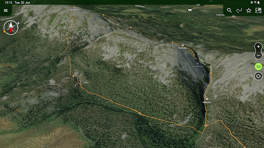
• 3D aerial and satellite imagery
• Worldwide outdoor map based on OpenStreetMap data
• Offline maps, preloading maps of selected areas into device memory for offline use
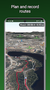
• Recording and displaying traveled routes, pre-planning of routes
• Drawing areas and measuring surface areas
• Sharing location among users, drawing another user's track on your own map
• Property boundaries and identifiers as separate map layers on top of other maps
The Plus subscription can be purchased as a one-time payment for €8.90 / 3 months or as a recurring subscription for €18.90 / year, which amounts to only €1.58 / month.
Free features:
• Accurate topographic map based on data from the National Land Survey of Finland
• Aerial imagery from the National Land Survey of Finland
• Satellite images of the entire world
• Topographic maps of Sweden, Norway, Denmark, and Estonia
• Display and tracking of your location
• Coordinate display formats: WGS84, ETRS-TM35FIN, YKJ, KKJ, and MGRS
• Compass, map rotation based on direction of travel
• Navigation to a destination, displaying direction and distance
• Place name search
• Distance measurement
• Saving your own places
• Organizing places and routes into groups
• Sharing and importing places and routes as GPX files
• Backup to your personal Google Drive
• Heart rate monitoring with BLE heart rate sensors
Plus subscription additionally includes:
• Highly detailed topographic map with water depth information
• Hillshaded topographic map clearly showing elevation differences
• 3D aerial and satellite imagery
• Worldwide outdoor map based on OpenStreetMap data
• Offline maps, preloading maps of selected areas into device memory for offline use
• Recording and displaying traveled routes, pre-planning of routes
• Drawing areas and measuring surface areas
• Sharing location among users, drawing another user's track on your own map
• Property boundaries and identifiers as separate map layers on top of other maps
The Plus subscription can be purchased as a one-time payment for €8.90 / 3 months or as a recurring subscription for €18.90 / year, which amounts to only €1.58 / month.
Aktualisiert am
Was die Sicherheit angeht, solltest du nachvollziehen, wie Entwickler deine Daten erheben und weitergeben. Die Datenschutz- und Sicherheitspraktiken können je nach Verwendung, Region und Alter des Nutzers variieren. Diese Informationen wurden vom Entwickler zur Verfügung gestellt und können jederzeit von ihm geändert werden.

Diese App kann die folgenden Datentypen an Dritte weitergeben
Standort

Keine Daten erhoben

Daten werden bei der Übertragung verschlüsselt

Daten können nicht gelöscht werden
Bewertungen und Rezensionen
4.1
17.7 Tsg. Rezensionen
Neuigkeiten
Minor fixes and technical improvements.
Support für diese App
Informationen zum Entwickler
MapsiTech Oy
support@mapsitech.fi
Valborginkatu 8F 16
37100 NOKIA
Finland
+358 41 3631806