Syslor AR
100+
Downloads

Everyone
info


About this app
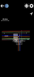
Coupled with the Syslor GNSS receiver, this application, designed for field operators, allows them to visualise 3D models in Augmented Reality (project utility networks, existing utility networks, road projects, BIM projects, etc). The main features are :
- Tracing of buried networks
- Object attributes (type/actual depth/diameter)
- Distance travelled counter
- Manage the display of your objects
- Visualising your trenches in Augmented Reality following the survey on the Syslor Récolement application
Additional features :
- Possible adaptation with your GIS
- Management of topographic coordinate systems
To use the application, you must have :
- An account on the Syslor portal (https://portalsyslor.com/fr)
- A Syslor GNSS receiver
- An "Augmented Reality" type subscription
Any questions? Contact us (https://syslor.net/en/contact-us/)
Updated on
Safety starts with understanding how developers collect and share your data. Data privacy and security practices may vary based on your use, region, and age. The developer provided this information and may update it over time.

No data shared with third parties
Learn more about how developers declare sharing

This app may collect these data types
Personal info, App activity and 2 others

Data isn’t encrypted
Data can’t be deleted
What's new
Improvements and bug fixes


