
Fogos.pt
3.9star
2.45K reviews

Everyone
info
100K+
Downloads

Everyone
Learn more
About this app
Fogos.pt is Portugal's go-to app for tracking wildfires and civil protection incidents in real time.
Data is refreshed every 2 minutes, directly from Portugal's National Emergency and Civil Protection Authority (ANEPC).
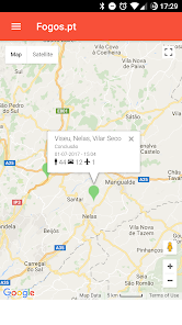
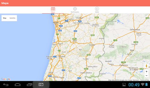
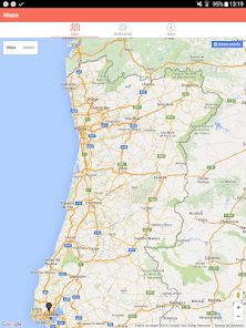
🗺️ LIVE MAP
• All active fires and incidents across Portugal
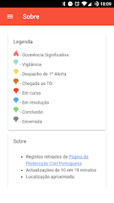
• Incident status: ongoing, under control, concluded...
• Resources on scene: firefighters, vehicles, and aircraft
• MODIS and VIIRS satellite hotspots
• Toggleable satellite and data overlay layers
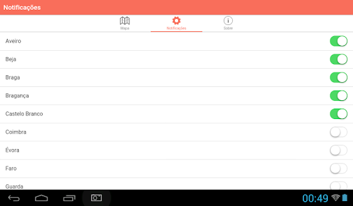
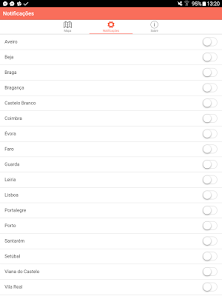
🔔 PERSONALISED ALERTS
• Subscribe by municipality — get notified the moment an incident starts in your area
• Proximity alerts: be warned when something happens close to your current location
• Choose between fire-only alerts or all incident types
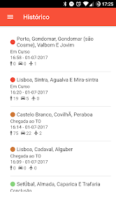
📋 FULL INCIDENT DETAILS
• Location, live status and timeline
• Number of firefighters, vehicles, and aircraft deployed
• Local weather conditions and fire risk level
• Direct link for further information
📷 INCIDENT CAMERA
Photograph any incident with GPS coordinates, compass bearing, and timestamp embedded automatically in the image.
🔭 RADAR MODE
See active fires around you in augmented reality, with distance and details for each one.
⚠️ WEATHER WARNINGS
Check IPMA weather alerts directly in the app.
📊 STATISTICS
Fire data for today, yesterday, and recent days — personnel, vehicles, aircraft, and incidents by district.
🔒 PRIVACY
Your location is used only on your device for proximity alerts. It is never sent to our servers.
Official Sources:
ANEPC (Portuguese National Authority for Emergency and Civil Protection): https://prociv.gov.pt
ANEPC Incidents Information: https://prociv.gov.pt/pt/ocorrencias/
IPMA (Portuguese Institute for Sea and Atmosphere): https://www.ipma.pt
Disclaimer:
Fogos.pt is an independent application and is not affiliated with, endorsed by, or representing any government entity, including ANEPC or IPMA. Information provided in the app is based on publicly available official data sources.
Data is refreshed every 2 minutes, directly from Portugal's National Emergency and Civil Protection Authority (ANEPC).
🗺️ LIVE MAP
• All active fires and incidents across Portugal
• Incident status: ongoing, under control, concluded...
• Resources on scene: firefighters, vehicles, and aircraft
• MODIS and VIIRS satellite hotspots
• Toggleable satellite and data overlay layers
🔔 PERSONALISED ALERTS
• Subscribe by municipality — get notified the moment an incident starts in your area
• Proximity alerts: be warned when something happens close to your current location
• Choose between fire-only alerts or all incident types
📋 FULL INCIDENT DETAILS
• Location, live status and timeline
• Number of firefighters, vehicles, and aircraft deployed
• Local weather conditions and fire risk level
• Direct link for further information
📷 INCIDENT CAMERA
Photograph any incident with GPS coordinates, compass bearing, and timestamp embedded automatically in the image.
🔭 RADAR MODE
See active fires around you in augmented reality, with distance and details for each one.
⚠️ WEATHER WARNINGS
Check IPMA weather alerts directly in the app.
📊 STATISTICS
Fire data for today, yesterday, and recent days — personnel, vehicles, aircraft, and incidents by district.
🔒 PRIVACY
Your location is used only on your device for proximity alerts. It is never sent to our servers.
Official Sources:
ANEPC (Portuguese National Authority for Emergency and Civil Protection): https://prociv.gov.pt
ANEPC Incidents Information: https://prociv.gov.pt/pt/ocorrencias/
IPMA (Portuguese Institute for Sea and Atmosphere): https://www.ipma.pt
Disclaimer:
Fogos.pt is an independent application and is not affiliated with, endorsed by, or representing any government entity, including ANEPC or IPMA. Information provided in the app is based on publicly available official data sources.
Updated on
Safety starts with understanding how developers collect and share your data. Data privacy and security practices may vary based on your use, region, and age. The developer provided this information and may update it over time.

No data shared with third parties
Learn more about how developers declare sharing

No data collected
Learn more about how developers declare collection

Data is encrypted in transit

Data can’t be deleted
Ratings and reviews
3.9
2.34K reviews

A Google user
- Flag inappropriate
June 11, 2019
Since I got a new Android phone, notifications have only worked intermittently, even with the latest Fogos upgrade. I've contacted the developers who have shown little interest, they just say that no-one else has a problem. I've sent screen shots of the settings in my phone to confirm I have everything set up correctly for notifications but they are not even responding to my messages now. Without notifications, the app is pretty useless.
20 people found this review helpful

Katia CH
- Flag inappropriate
- Show review history
May 31, 2024
Just updating my review as after over a year with a black screen and no map, I've just opened the app and I have a map! I really hope it will stay this way as this app is so essential. I would happily pay a yearly fee if it meant it could be more reliable and glitch free.
16 people found this review helpful

Moira Marriott
- Flag inappropriate
- Show review history
August 22, 2023
Disappointed, this is so important to be correct, not a game , so when info isn't shown, updated, it could put people at risk. 2021, 2022 used the app and felt confident. Unfortunately, this year, I have uninstalled and reinstalled. No change . Again no map, so uninstalling .
12 people found this review helpful
What’s new
- New map layers panel — easily toggle satellite, MODIS, and VIIRS overlays
- Refreshed fire icons and a new scale bar on the map
- New incident camera — take photos with GPS location, compass, and timestamp embedded automatically
- Improved radar mode with more details about each fire
- Nearby alerts now cover all incident types in your area
- General performance improvements and bug fixes
Everyone
Learn moreApp support
About the developer
João Tiago Silveira Pina
eu@tomahock.com
Portugal