
Vallée d'Ossau Pyrénées
10K+
Downloads

Everyone
info


About this app
The Ossau Valley offers an ideal playground in the Pyrenees for outdoor sports.
Its natural setting, shaped by an intense pastoral activity, offers a multitude of spots, adapted to all levels of practice for hikers, bikers and runners.
Ossau Valley has all the assets to please you, whether you come with family or sports friends ! Discover our trail routes and spots, take advantage of the variety of our network and surpass yourself on 3 vertical kilometers.
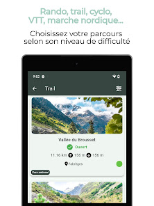
A mecca for hikers, with 64 circuits (some of which are located in the Pyrenees National Park), its magnificent landscapes will delight walkers of all levels.
Enjoy Nordic walking, a fast-paced activity using large skating poles.
And don't forget the facilities on offer in the area: Bike park, Enduro park, Pump track, Mountain bike initiation zone, Véloroute... Something for everyone!
Cycling enthusiasts will also be well catered for: the Ossau Valley boasts 19 mountain bike loops (including two Enduro circuits). The "Pyrénées béarnaises et Vallée d'Ossau" mountain-biking site is certified by the French Cycling Federation (FFC).
And on the road side, two legendary Tour de France passes: the Aubisque and the Marie-Blanque!
Welcome to the Ossau Valley, land of adventure!
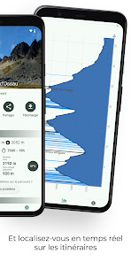
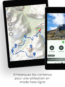
Once the app is installed, you will be able to download maps for offline operation : IGN Maps (french detailed maps) and Open Topo Map. All the routes and associated elevation profiles are likewise embedded in the app.
Many features will help you practice outdoor sports :
• get your location on the detailed IGN maps with the GPS
• record your chronos
• description of the route and points of interest
• monitoring alert to be notified if you move away from the route
• call or send an emergency SMS in case of problems
• sending predefined SMS to your contacts
• reporting a problem on the route
• adding comments
• sharing on social networks
• weather (OpenWeatherMap)
Its natural setting, shaped by an intense pastoral activity, offers a multitude of spots, adapted to all levels of practice for hikers, bikers and runners.
Ossau Valley has all the assets to please you, whether you come with family or sports friends ! Discover our trail routes and spots, take advantage of the variety of our network and surpass yourself on 3 vertical kilometers.
A mecca for hikers, with 64 circuits (some of which are located in the Pyrenees National Park), its magnificent landscapes will delight walkers of all levels.
Enjoy Nordic walking, a fast-paced activity using large skating poles.
And don't forget the facilities on offer in the area: Bike park, Enduro park, Pump track, Mountain bike initiation zone, Véloroute... Something for everyone!
Cycling enthusiasts will also be well catered for: the Ossau Valley boasts 19 mountain bike loops (including two Enduro circuits). The "Pyrénées béarnaises et Vallée d'Ossau" mountain-biking site is certified by the French Cycling Federation (FFC).
And on the road side, two legendary Tour de France passes: the Aubisque and the Marie-Blanque!
Welcome to the Ossau Valley, land of adventure!
Once the app is installed, you will be able to download maps for offline operation : IGN Maps (french detailed maps) and Open Topo Map. All the routes and associated elevation profiles are likewise embedded in the app.
Many features will help you practice outdoor sports :
• get your location on the detailed IGN maps with the GPS
• record your chronos
• description of the route and points of interest
• monitoring alert to be notified if you move away from the route
• call or send an emergency SMS in case of problems
• sending predefined SMS to your contacts
• reporting a problem on the route
• adding comments
• sharing on social networks
• weather (OpenWeatherMap)
Updated on
Safety starts with understanding how developers collect and share your data. Data privacy and security practices may vary based on your use, region, and age. The developer provided this information and may update it over time.

No data shared with third parties
Learn more about how developers declare sharing

This app may collect these data types
Personal info, Photos and videos, and Device or other IDs

Data isn’t encrypted

You can request that data be deleted
What’s new
Fixes and improvements
App support
phone
Phone number
+33631279201
About the developer
Yoomigo SARL
jeanphi@yoomigo.fr
190 Rue du Fayard
38850 Charavines
France
+33 6 31 27 92 01


